
National Trails System facts for kids
The National Trails System is a special group of trails across the United States. These trails are set up to help protect and enjoy America's outdoor spaces and historic places. You can find four main types of trails in this system: national scenic trails, national historic trails, national recreation trails, and connecting or side trails.
These national trails offer many fun activities. You can go hiking, learn about history, or even go horseback riding. Some trails are great for biking, camping, or scenic driving. You can also enjoy water sports and other outdoor adventures. The National Trails System has 11 national scenic trails, 19 national historic trails, and over 1,300 national recreation trails. There are also seven connecting trails and one national geologic trail. Together, they stretch for more than 88,000 kilometers (54,681 miles)! You can find scenic and historic trails in every U.S. state. Virginia and Wyoming have the most, with six trails each.
The idea for these trails started with President Lyndon B. Johnson. He wanted a program to build public trails for everyone, both in cities and in wild areas. In 1966, a report called Trails for America suggested a network of trails. This led to the creation of the National Trails System Act on October 2, 1968. This act officially started the program for long-distance nature trails. It also named the Appalachian Trail and the Pacific Crest Trail as the first two national scenic trails. Later, in 1978, national historic trails were added as a new type of trail. This was for trails that were very important to American history.
The national scenic and historic trails are long-distance paths created by the U.S. Congress. They are managed by different government groups. These include the National Park Service (NPS), the United States Forest Service (USFS), and the Bureau of Land Management (BLM). These groups work together with states, local governments, and private landowners. Their goal is to protect the land and make sure the trails are open for everyone to enjoy. Volunteers also play a huge role in supporting these trails. They work with the government agencies to keep the trails in great shape.
Contents
National Scenic Trails
National scenic trails are designed for outdoor fun and to protect beautiful natural areas. These places have important scenic, natural, cultural, or historic value. These trails are continuous paths where you can't use motorized vehicles. You can hike them from one end to the other, which is called thru-hiking. Or, you can just hike shorter parts of them. One exception is the Natchez Trace NST, which has five shorter, separate trail sections.
The Trails for America report said that each National Scenic Trail should be a "superlative quality" place for recreation. These trails let you explore amazing parts of the U.S. For example, you can reach the top of the Appalachian Mountains on the Appalachian Trail. In the west, you can hike the Continental Divide Trail along the Rocky Mountains. The Pacific Crest Trail takes you through the Cascade and Sierra Nevada mountains. These three trails together are known as the Triple Crown of Hiking. Other scenic trails explore Florida's wetlands, the northern forests of the North Country Trail, and the deserts and mountains of Arizona.
These eleven national scenic trails stretch for about 17,800 miles (28,646 kilometers) in total. Sometimes, the exact length can change a bit. This is because trails are still being built or measured in different ways.
Some of these trails, like the Appalachian, Natchez Trace, and Potomac Heritage, are managed directly by the National Park Service. The NPS treats them like long, narrow parks. For other trails, the NPS works more as a helper, coordinating with local groups.
| Name | States on route | Length | Description |
|---|---|---|---|
| Appalachian | Georgia, North Carolina, Tennessee, Virginia, West Virginia, Maryland, Pennsylvania, New Jersey, New York, Connecticut, Massachusetts, Vermont, New Hampshire, Maine | 2,189 mi (3,520 km) | This trail goes through the Appalachian Mountains. It stretches from Georgia to Maine. Many people hike the whole trail each year. Millions more visit for shorter trips. You can see famous parks like Great Smoky Mountains National Park along the way. |
| Arizona | Arizona | 800 mi (1,290 km) | This trail runs the entire length of Arizona. It starts near the Mexican border and goes all the way to Utah. You'll see many different landscapes. These include deserts, mountains, and deep canyons. |
| Continental Divide | Montana, Idaho, Wyoming, Colorado, New Mexico | 3,200 mi (5,150 km) | This trail goes from Mexico to Canada. It mostly follows the crest of the Rocky Mountains. This is where rivers separate, flowing to either the Pacific or Atlantic Oceans. It passes through famous places like Yellowstone National Park. |
| Florida | Florida | 1,300 mi (2,090 km) | The Florida Trail goes from the swamps of Big Cypress National Preserve to the beaches of Gulf Islands National Seashore. It also goes around Lake Okeechobee. You'll see many state and national forests. |
| Ice Age | Wisconsin | 1,000 mi (1,610 km) | This trail in Wisconsin shows where a huge glacier once covered North America. When the glacier melted, it left behind unique landforms. These include kettles and drumlins. |
| Natchez Trace | Tennessee, Mississippi | 64 mi (100 km) | The Natchez Trace was an old path used by Native Americans for trade. Later, settlers used it as a major road. Today, it's part of the Natchez Trace Parkway. The trail has five separate sections through forests and prairies. |
| New England | Massachusetts, Connecticut | 215 mi (350 km) | This trail is a footpath from Long Island Sound to the New Hampshire border. It connects small towns, farms, and forests. You'll also see lakes and rocky ridges. |
| North Country | Vermont, New York, Pennsylvania, Ohio, Michigan, Wisconsin, Minnesota, North Dakota | 4,600 mi (7,400 km) | This very long trail connects over 160 state parks and national forests. It goes through many different landscapes. These include mountains, prairies, farmlands, and the coast of Lake Superior. |
| Pacific Crest | California, Oregon, Washington | 2,650 mi (4,260 km) | The PCT follows mountain passes and crests from Mexico to Canada. It goes through 7 national parks. These include Yosemite National Park and Crater Lake National Park. You'll see deserts, glaciated mountains, and volcanic peaks. |
| Pacific Northwest | Montana, Idaho, Washington | 1,200 mi (1,930 km) | This trail connects the Continental Divide in Glacier National Park to the Pacific Ocean. It showcases the Rocky Mountains and the Olympic Peninsula. You even take a ferry ride across Puget Sound. |
| Potomac Heritage | Pennsylvania, Maryland, District of Columbia, Virginia | 710 mi (1,140 km) | This trail follows the Potomac River. It connects the nation's capital to historic trade routes. It includes parts of the Chesapeake and Ohio Canal towpath and the Mount Vernon Trail. |
National Historic Trails
The 19 national historic trails protect important land or water routes. These routes tell stories about the history of the United States. They show early European travels and the nation's fight for independence. They also mark westward journeys like the Oregon Trail and California Trail. Other trails show how trade grew, like the Santa Fe Trail. Sadly, some trails, like the Trail of Tears, remember the difficult journeys of Native American groups who were forced to leave their homes.
These trails follow the paths of important historical journeys. They are often networks of partner sites along marked driving routes. They are not always exact walking trails as they were long ago. You can find interpretive sites at national parks and local museums along these trails. The National Historic Trails Interpretive Center in Wyoming has exhibits about westward travel.
National historic trails were officially created in 1978. They have a total length of about 37,000 miles (59,545 km). Many trails have several branches, making them much longer than a single path.
| Name | States on route | Length | Description |
|---|---|---|---|
| Ala Kahakai | Hawaii | 175 mi (280 km) | This trail on Hawaiʻi island protects ancient paths used by Native Hawaiians. It goes through lava fields and sandy beaches. You can see old fishponds and temples along the way. |
| California | Missouri, Kansas, Nebraska, Colorado, Wyoming, Idaho, Utah, Nevada, California, Oregon | 5,600 mi (9,010 km) | This trail was used by thousands of people heading to California. The discovery of gold in 1848 led to the California Gold Rush. Many people traveled this route, which helped California become a state. This growth also had a big impact on the Native Americans living there. |
| Captain John Smith Chesapeake | Virginia, Maryland, Delaware, District of Columbia | 3,000 mi (4,830 km) | This water trail follows the routes of John Smith. He explored and mapped Chesapeake Bay in the early 1600s. Today, the trail includes historical sites and wildlife refuges. You can also canoe and kayak on the water trails. |
| El Camino Real de los Tejas | Texas, Louisiana | 2,600 mi (4,180 km) | This "Royal Road of the Tejas" was a group of roads in Spanish Texas. It was used for trade and communication. The Spanish built many missions along this route in the 1700s. |
| El Camino Real de Tierra Adentro | New Mexico, Texas | 404 mi (650 km) | This "Royal Road of the Interior" was used for hundreds of years. It connected Mexico City to Santa Fe for trade and communication. It mostly follows the Rio Grande river. |
| Iditarod | Alaska | 2,350 mi (3,780 km) | This route in Alaska was used by gold prospectors and Alaska Natives. It became famous in 1925 when sled dogs carried medicine to stop a disease outbreak. Today, the famous Iditarod Trail Sled Dog Race follows part of this trail. |
| Juan Bautista de Anza | Arizona, California | 1,200 mi (1,930 km) | Juan Bautista de Anza led an expedition in 1775-1776 to settle California. His route became El Camino Real, which connects 21 missions. You can visit many Hispanic heritage sites along this trail. |
| Lewis and Clark | Pennsylvania, West Virginia, Ohio, Kentucky, Indiana, Illinois, Missouri, Kansas, Iowa, Nebraska, South Dakota, North Dakota, Montana, Idaho, Oregon, Washington. | 4,900 mi (7,890 km) | Meriwether Lewis and William Clark led an expedition from 1803-1806. They explored and mapped the new lands of the Louisiana Purchase. They met many Native American tribes and discovered new animals and plants. |
| Mormon Pioneer | Illinois, Iowa, Nebraska, Wyoming, Utah | 1,300 mi (2,090 km) | This trail was used by members of The Church of Jesus Christ of Latter-day Saints. They traveled from Illinois to the Salt Lake Valley to find a safe home. Thousands of people made this difficult journey, some even pulling handcarts. |
| Nez Perce (Nee-Me-Poo) | Oregon, Idaho, Wyoming, Montana | 1,170 mi (1,880 km) | This trail follows the path of the Nez Perce people in 1877. They were forced to leave their homes and tried to find safety. A U.S. Army unit chased them for four months. You can visit battle sites and other important places along this trail. |
| Old Spanish | New Mexico, Colorado, Utah, Arizona, Nevada, California | 2,700 mi (4,350 km) | This trail was a trade route between New Mexico and Los Angeles. Mexican merchants used it to transport goods on mules. It crossed deserts and mountains. |
| Oregon | Missouri, Kansas, Nebraska, Wyoming, Idaho, Oregon, Washington | 2,170 mi (3,490 km) | Thousands of families traveled this trail in covered wagons to start new lives in the West. It was a risky journey, but it led to new settlements and growth in the Oregon Country. |
| Overmountain Victory | Virginia, Tennessee, North Carolina, South Carolina | 330 mi (530 km) | This trail marks the path of the Overmountain Men militia during the American Revolutionary War. In 1780, they marched across the Appalachian Mountains. They won an important victory at the Battle of Kings Mountain. |
| Pony Express | Missouri, Kansas, Nebraska, Wyoming, Colorado, Utah, Nevada, California | 2,000 mi (3,220 km) | The Pony Express was a mail delivery service that lasted only 18 months in 1860-1861. Riders on horseback delivered mail across the country in just ten days. You can still visit some of the old stations. |
| Santa Fe | Missouri, Kansas, Oklahoma, Colorado, New Mexico | 1,203 mi (1,940 km) | This trail was a major trade route between Missouri and Santa Fe. It was used for 25 years until the Mexican–American War. After the war, it became busy with people moving west and freight. |
| Selma to Montgomery | Alabama | 54 mi (90 km) | This trail remembers the 1965 Selma to Montgomery marches. These were peaceful protests during the civil rights movement. They helped lead to the Voting Rights Act of 1965. You can visit historical markers and interpretive centers. |
| Star-Spangled Banner | Maryland, Virginia, District of Columbia | 290 mi (470 km) | This trail highlights the history of the War of 1812 in the Chesapeake Bay area. It includes sites like Fort McHenry, where the American flag flying inspired "The Star-Spangled Banner". |
| Trail of Tears | Georgia, North Carolina, Tennessee, Alabama, Kentucky, Illinois, Missouri, Arkansas, Oklahoma | 5,045 mi (8,120 km) | This trail remembers the forced removal of thousands of Cherokee, Muscogee, Seminole, Chickasaw, and Choctaw people. They were forced to leave their homes in the Southeast and move to Oklahoma. Many people died on these difficult journeys. |
| Washington–Rochambeau Revolutionary Route |
Rhode Island, Connecticut, New York, New Jersey, Pennsylvania, Delaware, Maryland, Virginia, District of Columbia, Massachusetts | 1,000 mi (1,610 km) | This trail follows the path of French and American armies during the American Revolutionary War. In 1781, they marched to Williamsburg, Virginia. They defeated the British army at the siege of Yorktown, which helped win independence for the colonies. |
Connecting or Side Trails
Connecting or side trails are special paths that extend the main national trails. They help link trails to other important places. The Secretary of the Interior officially names these trails. Seven side trails have been created:
- Timms Hill Trail – 14 mi (23 km), connects the Ice Age Trail to Wisconsin's highest point, Timms Hill (1990)
- Anvik Connector – 86 mi (138 km), joins the Iditarod Trail to the village of Anvik, Alaska (1990)
- Susquehanna River Component Connecting Trail – 552 mi (888 km), extends the Captain John Smith Chesapeake National Historic Trail up the Susquehanna River in Pennsylvania and New York (2012)
- Chester River Component Connecting Trail – 46 mi (74 km), extends the Captain John Smith Chesapeake National Historic Trail up the Chester River in Maryland (2012)
- Upper Nanticoke River Component Connecting Trail – 23 mi (37 km), extends the Captain John Smith Chesapeake National Historic Trail up the Nanticoke River in Delaware (2012)
- Upper James River Component Connecting Trail – 220 mi (350 km), extends the Captain John Smith Chesapeake National Historic Trail up the James River in Virginia (2012)
- Marion to Selma Connecting Trail – 28 mi (45 km), connects the Selma to Montgomery National Historic Trail to Marion, Alabama
National Recreation Trails

A National Recreation Trail (NRT) is a special name given to existing trails. These trails help with recreation and conservation goals across the country. There are over 1,300 NRTs in all fifty states. They are on federal, state, city, tribal, and private lands. They are open for public use and can be short or very long. Together, they cover more than 29,000 miles (47,000 km).
Most NRTs are hiking trails. But many are also multi-use trails or bike paths. This includes rail trails (old railroad lines turned into paths) and greenways. Some trails are for watercraft, horses, cross-country skis, or off-road vehicles. There's even a special group of water trails. To become an NRT, a trail must be complete, well-designed, well-kept, and open to everyone.
The National Park Service and the U.S. Forest Service work together to manage the National Recreation Trails Program. They get help from other groups, like American Trails. Trail managers can apply for their trails to become NRTs. If a trail is chosen, it gets special benefits. These include promotion, use of the NRT logo, and help with funding.
National Geologic Trail
The first national geologic trail was created in 2009. It's a special type of trail that focuses on geology.
| Name | States on route | Length | Description |
|---|---|---|---|
| Ice Age Floods | Washington, Oregon, Idaho, Montana | 3,400 mi (5,470 km) | This trail shows the path of huge floods that happened long ago. From about 18,000 to 15,000 years ago, a giant ice dam broke many times. This released massive floods that carved out amazing landforms. These include cliffs, waterfalls, and giant ripples in the land. |
Images for kids
-
The Delaware Water Gap National Recreation Area on the Appalachian Trail.
-
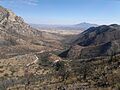
The Coronado National Memorial on the Arizona Trail.
-

Glacier National Park on the Continental Divide Trail.
-
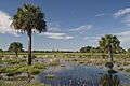
A swamp on the Florida Trail.
-

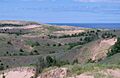
Kettle Moraine State Forest on the Ice Age Trail.
-

A section of the Natchez Trace Trail.
-

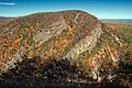
Ragged Mountain on the New England National Scenic Trail.
-
Pictured Rocks National Lakeshore on the North Country Trail.
-

Alpine Lakes Wilderness on the Pacific Crest Trail.
-

Olympic National Park on the Pacific Northwest Trail.
-
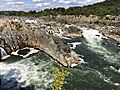
Great Falls on the Potomac Heritage Trail.
-

A trail section on the Ala Kahakai National Historic Trail.
-
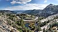
Donner Pass on the California Trail.
-
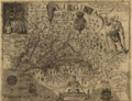
A historic map of Chesapeake Bay by John Smith.
-
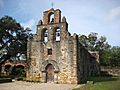
Mission Espada on the El Camino Real de los Tejas National Historic Trail.
-

Ysleta Mission on the El Camino Real de Tierra Adentro National Historic Trail.
-

Sled dogs on the Iditarod National Historic Trail.
-

Mission San Carlos Borromeo on the Juan Bautista de Anza National Historic Trail.
-
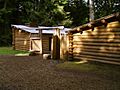
A replica of Fort Clatsop on the Lewis and Clark National Historic Trail.
-
Independence Rock on the Mormon Pioneer National Historic Trail.
-
Big Hole National Battlefield on the Nez Perce National Historic Trail.
-
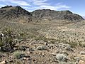
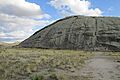
A desert landscape on the Old Spanish National Historic Trail.
-
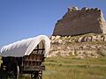
A covered wagon at Scotts Bluff National Monument on the Oregon Trail.
-
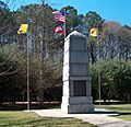
Abingdon, Virginia on the Overmountain Victory National Historic Trail.
-

Hollenberg Pony Express Station on the Pony Express National Historic Trail.
-
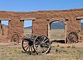
Fort Union National Monument on the Santa Fe National Historic Trail.
-

The Edmund Pettus Bridge on the Selma to Montgomery National Historic Trail.
-
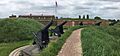
Fort McHenry National Monument and Historic Shrine on the Star-Spangled Banner National Historic Trail.
-
A monument at New Echota on the Trail of Tears National Historic Trail.
-

A reenactment at the Colonial National Historical Park on the Washington–Rochambeau Revolutionary Route.
-
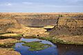
Dry Falls on the Ice Age Floods National Geologic Trail.
_(10355280153).jpg)


.jpg)


.jpg)


.jpg)


.jpg)
The National Trails System is a special group of trails across the United States. These trails are set up to help protect and enjoy America's outdoor spaces and historic places. You can find four main types of trails in this system: national scenic trails, national historic trails, national recreation trails, and connecting or side trails.
These national trails offer many fun activities. You can go hiking, learn about history, or even go horseback riding. Some trails are great for biking, camping, or scenic driving. You can also enjoy water sports and other outdoor adventures. The National Trails System has 11 national scenic trails, 19 national historic trails, and over 1,300 national recreation trails. There are also seven connecting trails and one national geologic trail. Together, they stretch for more than 88,000 kilometers (54,681 miles)! You can find scenic and historic trails in every U.S. state. Virginia and Wyoming have the most, with six trails each.
The idea for these trails started with President Lyndon B. Johnson. He wanted a program to build public trails for everyone, both in cities and in wild areas. In 1966, a report called Trails for America suggested a network of trails. This led to the creation of the National Trails System Act on October 2, 1968. This act officially started the program for long-distance nature trails. It also named the Appalachian Trail and the Pacific Crest Trail as the first two national scenic trails. Later, in 1978, national historic trails were added as a new type of trail. This was for trails that were very important to American history.

The national scenic and historic trails are long-distance paths created by the U.S. Congress. They are managed by different government groups. These include the National Park Service (NPS), the United States Forest Service (USFS), and the Bureau of Land Management (BLM). These groups work together with states, local governments, and private landowners. Their goal is to protect the land and make sure the trails are open for everyone to enjoy. Volunteers also play a huge role in supporting these trails. They work with the government agencies to keep the trails in great shape.
National Scenic Trails
National scenic trails are designed for outdoor fun and to protect beautiful natural areas. These places have important scenic, natural, cultural, or historic value. These trails are continuous paths where you can't use motorized vehicles. You can hike them from one end to the other, which is called thru-hiking. Or, you can just hike shorter parts of them. One exception is the Natchez Trace NST, which has five shorter, separate trail sections.
The Trails for America report said that each National Scenic Trail should be a "superlative quality" place for recreation. These trails let you explore amazing parts of the U.S. For example, you can reach the top of the Appalachian Mountains on the Appalachian Trail. In the west, you can hike the Continental Divide Trail along the Rocky Mountains. The Pacific Crest Trail takes you through the Cascade and Sierra Nevada mountains. These three trails together are known as the Triple Crown of Hiking. Other scenic trails explore Florida's wetlands, the northern forests of the North Country Trail, and the deserts and mountains of Arizona.
These eleven national scenic trails stretch for about 17,800 miles (28,646 kilometers) in total. Sometimes, the exact length can change a bit. This is because trails are still being built or measured in different ways.
Some of these trails, like the Appalachian, Natchez Trace, and Potomac Heritage, are managed directly by the National Park Service. The NPS treats them like long, narrow parks. For other trails, the NPS works more as a helper, coordinating with local groups.
| Name | States on route | Length | Description |
|---|---|---|---|
| Appalachian | Georgia, North Carolina, Tennessee, Virginia, West Virginia, Maryland, Pennsylvania, New Jersey, New York, Connecticut, Massachusetts, Vermont, New Hampshire, Maine | 2,189 mi (3,520 km) | This trail goes through the Appalachian Mountains. It stretches from Georgia to Maine. Many people hike the whole trail each year. Millions more visit for shorter trips. You can see famous parks like Great Smoky Mountains National Park along the way. |
| Arizona | Arizona | 800 mi (1,290 km) | This trail runs the entire length of Arizona. It starts near the Mexican border and goes all the way to Utah. You'll see many different landscapes. These include deserts, mountains, and deep canyons. |
| Continental Divide | Montana, Idaho, Wyoming, Colorado, New Mexico | 3,200 mi (5,150 km) | This trail goes from Mexico to Canada. It mostly follows the crest of the Rocky Mountains. This is where rivers separate, flowing to either the Pacific or Atlantic Oceans. It passes through famous places like Yellowstone National Park. |
| Florida | Florida | 1,300 mi (2,090 km) | The Florida Trail goes from the swamps of Big Cypress National Preserve to the beaches of Gulf Islands National Seashore. It also goes around Lake Okeechobee. You'll see many state and national forests. |
| Ice Age | Wisconsin | 1,000 mi (1,610 km) | This trail in Wisconsin shows where a huge glacier once covered North America. When the glacier melted, it left behind unique landforms. These include kettles and drumlins. |
| Natchez Trace | Tennessee, Mississippi | 64 mi (100 km) | The Natchez Trace was an old path used by Native Americans for trade. Later, settlers used it as a major road. Today, it's part of the Natchez Trace Parkway. The trail has five separate sections through forests and prairies. |
| New England | Massachusetts, Connecticut | 215 mi (350 km) | This trail is a footpath from Long Island Sound to the New Hampshire border. It connects small towns, farms, and forests. You'll also see lakes and rocky ridges. |
| North Country | Vermont, New York, Pennsylvania, Ohio, Michigan, Wisconsin, Minnesota, North Dakota | 4,600 mi (7,400 km) | This very long trail connects over 160 state parks and national forests. It goes through many different landscapes. These include mountains, prairies, farmlands, and the coast of Lake Superior. |
| Pacific Crest | California, Oregon, Washington | 2,650 mi (4,260 km) | The PCT follows mountain passes and crests from Mexico to Canada. It goes through 7 national parks. These include Yosemite National Park and Crater Lake National Park. You'll see deserts, glaciated mountains, and volcanic peaks. |
| Pacific Northwest | Montana, Idaho, Washington | 1,200 mi (1,930 km) | This trail connects the Continental Divide in Glacier National Park to the Pacific Ocean. It showcases the Rocky Mountains and the Olympic Peninsula. You even take a ferry ride across Puget Sound. |
| Potomac Heritage | Pennsylvania, Maryland, District of Columbia, Virginia | 710 mi (1,140 km) | This trail follows the Potomac River. It connects the nation's capital to historic trade routes. It includes parts of the Chesapeake and Ohio Canal towpath and the Mount Vernon Trail. |
National Historic Trails
The 19 national historic trails protect important land or water routes. These routes tell stories about the history of the United States. They show early European travels and the nation's fight for independence. They also mark westward journeys like the Oregon Trail and California Trail. Other trails show how trade grew, like the Santa Fe Trail. Sadly, some trails, like the Trail of Tears, remember the difficult journeys of Native American groups who were forced to leave their homes.
These trails follow the paths of important historical journeys. They are often networks of partner sites along marked driving routes. They are not always exact walking trails as they were long ago. You can find interpretive sites at national parks and local museums along these trails. The National Historic Trails Interpretive Center in Wyoming has exhibits about westward travel.
National historic trails were officially created in 1978. They have a total length of about 37,000 miles (59,545 km). Many trails have several branches, making them much longer than a single path.
| Name | States on route | Length | Description |
|---|---|---|---|
| Ala Kahakai | Hawaii | 175 mi (280 km) | This trail on Hawaiʻi island protects ancient paths used by Native Hawaiians. It goes through lava fields and sandy beaches. You can see old fishponds and temples along the way. |
| California | Missouri, Kansas, Nebraska, Colorado, Wyoming, Idaho, Utah, Nevada, California, Oregon | 5,600 mi (9,010 km) | This trail was used by thousands of people heading to California. The discovery of gold in 1848 led to the California Gold Rush. Many people traveled this route, which helped California become a state. This growth also had a big impact on the Native Americans living there. |
| Captain John Smith Chesapeake | Virginia, Maryland, Delaware, District of Columbia | 3,000 mi (4,830 km) | This water trail follows the routes of John Smith. He explored and mapped Chesapeake Bay in the early 1600s. Today, the trail includes historical sites and wildlife refuges. You can also canoe and kayak on the water trails. |
| El Camino Real de los Tejas | Texas, Louisiana | 2,600 mi (4,180 km) | This "Royal Road of the Tejas" was a group of roads in Spanish Texas. It was used for trade and communication. The Spanish built many missions along this route in the 1700s. |
| El Camino Real de Tierra Adentro | New Mexico, Texas | 404 mi (650 km) | This "Royal Road of the Interior" was used for hundreds of years. It connected Mexico City to Santa Fe for trade and communication. It mostly follows the Rio Grande river. |
| Iditarod | Alaska | 2,350 mi (3,780 km) | This route in Alaska was used by gold prospectors and Alaska Natives. It became famous in 1925 when sled dogs carried medicine to stop a disease outbreak. Today, the famous Iditarod Trail Sled Dog Race follows part of this trail. |
| Juan Bautista de Anza | Arizona, California | 1,200 mi (1,930 km) | Juan Bautista de Anza led an expedition in 1775-1776 to settle California. His route became El Camino Real, which connects 21 missions. You can visit many Hispanic heritage sites along this trail. |
| Lewis and Clark | Pennsylvania, West Virginia, Ohio, Kentucky, Indiana, Illinois, Missouri, Kansas, Iowa, Nebraska, South Dakota, North Dakota, Montana, Idaho, Oregon, Washington. | 4,900 mi (7,890 km) | Meriwether Lewis and William Clark led an expedition from 1803-1806. They explored and mapped the new lands of the Louisiana Purchase. They met many Native American tribes and discovered new animals and plants. |
| Mormon Pioneer | Illinois, Iowa, Nebraska, Wyoming, Utah | 1,300 mi (2,090 km) | This trail was used by members of The Church of Jesus Christ of Latter-day Saints. They traveled from Illinois to the Salt Lake Valley to find a safe home. Thousands of people made this difficult journey, some even pulling handcarts. |
| Nez Perce (Nee-Me-Poo) | Oregon, Idaho, Wyoming, Montana | 1,170 mi (1,880 km) | This trail follows the path of the Nez Perce people in 1877. They were forced to leave their homes and tried to find safety. A U.S. Army unit chased them for four months. You can visit battle sites and other important places along this trail. |
| Old Spanish | New Mexico, Colorado, Utah, Arizona, Nevada, California | 2,700 mi (4,350 km) | This trail was a trade route between New Mexico and Los Angeles. Mexican merchants used it to transport goods on mules. It crossed deserts and mountains. |
| Oregon | Missouri, Kansas, Nebraska, Wyoming, Idaho, Oregon, Washington | 2,170 mi (3,490 km) | Thousands of families traveled this trail in covered wagons to start new lives in the West. It was a risky journey, but it led to new settlements and growth in the Oregon Country. |
| Overmountain Victory | Virginia, Tennessee, North Carolina, South Carolina | 330 mi (530 km) | This trail marks the path of the Overmountain Men militia during the American Revolutionary War. In 1780, they marched across the Appalachian Mountains. They won an important victory at the Battle of Kings Mountain. |
| Pony Express | Missouri, Kansas, Nebraska, Wyoming, Colorado, Utah, Nevada, California | 2,000 mi (3,220 km) | The Pony Express was a mail delivery service that lasted only 18 months in 1860-1861. Riders on horseback delivered mail across the country in just ten days. You can still visit some of the old stations. |
| Santa Fe | Missouri, Kansas, Oklahoma, Colorado, New Mexico | 1,203 mi (1,940 km) | This trail was a major trade route between Missouri and Santa Fe. It was used for 25 years until the Mexican–American War. After the war, it became busy with people moving west and freight. |
| Selma to Montgomery | Alabama | 54 mi (90 km) | This trail remembers the 1965 Selma to Montgomery marches. These were peaceful protests during the civil rights movement. They helped lead to the Voting Rights Act of 1965. You can visit historical markers and interpretive centers. |
| Star-Spangled Banner | Maryland, Virginia, District of Columbia | 290 mi (470 km) | This trail highlights the history of the War of 1812 in the Chesapeake Bay area. It includes sites like Fort McHenry, where the American flag flying inspired "The Star-Spangled Banner". |
| Trail of Tears | Georgia, North Carolina, Tennessee, Alabama, Kentucky, Illinois, Missouri, Arkansas, Oklahoma | 5,045 mi (8,120 km) | This trail remembers the forced removal of thousands of Cherokee, Muscogee, Seminole, Chickasaw, and Choctaw people. They were forced to leave their homes in the Southeast and move to Oklahoma. Many people died on these difficult journeys. |
| Washington–Rochambeau Revolutionary Route |
Rhode Island, Connecticut, New York, New Jersey, Pennsylvania, Delaware, Maryland, Virginia, District of Columbia, Massachusetts | 1,000 mi (1,610 km) | This trail follows the path of French and American armies during the American Revolutionary War. In 1781, they marched to Williamsburg, Virginia. They defeated the British army at the siege of Yorktown, which helped win independence for the colonies. |
Connecting or Side Trails
Connecting or side trails are special paths that extend the main national trails. They help link trails to other important places. The Secretary of the Interior officially names these trails. Seven side trails have been created:
- Timms Hill Trail – 14 mi (23 km), connects the Ice Age Trail to Wisconsin's highest point, Timms Hill (1990)
- Anvik Connector – 86 mi (138 km), joins the Iditarod Trail to the village of Anvik, Alaska (1990)
- Susquehanna River Component Connecting Trail – 552 mi (888 km), extends the Captain John Smith Chesapeake National Historic Trail up the Susquehanna River in Pennsylvania and New York (2012)
- Chester River Component Connecting Trail – 46 mi (74 km), extends the Captain John Smith Chesapeake National Historic Trail up the Chester River in Maryland (2012)
- Upper Nanticoke River Component Connecting Trail – 23 mi (37 km), extends the Captain John Smith Chesapeake National Historic Trail up the Nanticoke River in Delaware (2012)
- Upper James River Component Connecting Trail – 220 mi (350 km), extends the Captain John Smith Chesapeake National Historic Trail up the James River in Virginia (2012)
- Marion to Selma Connecting Trail – 28 mi (45 km), connects the Selma to Montgomery National Historic Trail to Marion, Alabama
National Recreation Trails
A National Recreation Trail (NRT) is a special name given to existing trails. These trails help with recreation and conservation goals across the country. There are over 1,300 NRTs in all fifty states. They are on federal, state, city, tribal, and private lands. They are open for public use and can be short or very long. Together, they cover more than 29,000 miles (47,000 km).
Most NRTs are hiking trails. But many are also multi-use trails or bike paths. This includes rail trails (old railroad lines turned into paths) and greenways. Some trails are for watercraft, horses, cross-country skis, or off-road vehicles. There's even a special group of water trails. To become an NRT, a trail must be complete, well-designed, well-kept, and open to everyone.
The National Park Service and the U.S. Forest Service work together to manage the National Recreation Trails Program. They get help from other groups, like American Trails. Trail managers can apply for their trails to become NRTs. If a trail is chosen, it gets special benefits. These include promotion, use of the NRT logo, and help with funding.
National Geologic Trail
The first national geologic trail was created in 2009. It's a special type of trail that focuses on geology.
| Name | States on route | Length | Description |
|---|---|---|---|
| Ice Age Floods | Washington, Oregon, Idaho, Montana | 3,400 mi (5,470 km) | This trail shows the path of huge floods that happened long ago. From about 18,000 to 15,000 years ago, a giant ice dam broke many times. This released massive floods that carved out amazing landforms. These include cliffs, waterfalls, and giant ripples in the land. |
Images for kids
-
The Delaware Water Gap National Recreation Area on the Appalachian Trail.
-
The Coronado National Memorial on the Arizona Trail.
-
Glacier National Park on the Continental Divide Trail.
-
A swamp on the Florida Trail.
-
Kettle Moraine State Forest on the Ice Age Trail.
-
A section of the Natchez Trace Trail.
-
Ragged Mountain on the New England National Scenic Trail.
-
Pictured Rocks National Lakeshore on the North Country Trail.
-
Olympic National Park on the Pacific Northwest Trail.
-
Great Falls on the Potomac Heritage Trail.
-
A trail section on the Ala Kahakai National Historic Trail.
-
Donner Pass on the California Trail.
-
A historic map of Chesapeake Bay by John Smith.
-
Mission Espada on the El Camino Real de los Tejas National Historic Trail.
-
Ysleta Mission on the El Camino Real de Tierra Adentro National Historic Trail.
-
Sled dogs on the Iditarod National Historic Trail.
-
Mission San Carlos Borromeo on the Juan Bautista de Anza National Historic Trail.
-
A replica of Fort Clatsop on the Lewis and Clark National Historic Trail.
-
Independence Rock on the Mormon Pioneer National Historic Trail.
-
Big Hole National Battlefield on the Nez Perce National Historic Trail.
-
A desert landscape on the Old Spanish National Historic Trail.
-
A covered wagon at Scotts Bluff National Monument on the Oregon Trail.
-
Abingdon, Virginia on the Overmountain Victory National Historic Trail.
-
Hollenberg Pony Express Station on the Pony Express National Historic Trail.
-
Fort Union National Monument on the Santa Fe National Historic Trail.
-
The Edmund Pettus Bridge on the Selma to Montgomery National Historic Trail.
-
Fort McHenry National Monument and Historic Shrine on the Star-Spangled Banner National Historic Trail.
-
A monument at New Echota on the Trail of Tears National Historic Trail.
-
A reenactment at the Colonial National Historical Park on the Washington–Rochambeau Revolutionary Route.
-
Dry Falls on the Ice Age Floods National Geologic Trail.
See also
 In Spanish: Sistema nacional de senderos de los Estados Unidos para niños
