
Great Falls (Potomac River) facts for kids
Quick facts for kids Great Falls |
|
|---|---|

The Great Falls as seen from Northern Virginia
|
|
| Lua error in Module:Infobox_mapframe at line 185: attempt to index field 'wikibase' (a nil value). | |
| Location | Montgomery County, Maryland and Fairfax County, Virginia, U.S. |
| Coordinates | 38°59′51″N 77°15′09″W / 38.99750°N 77.25250°W |
| Type | Steep Tiered Cascades |
| Elevation | 129 ft (39 m) |
| Total height | 47 ft (14 m) |
| Average width | 350 ft (110 m) |
| Run | 550 ft (170 m) |
| Watercourse | Potomac River |
| Average flow rate |
16,750 cu ft/s (474 m3/s) (est.) |
Great Falls is a cool spot on the Potomac River. It's a mix of fast-moving water and waterfalls. You can find it about 14 miles (22 km) upstream from Washington, D.C.. It sits right on the border between Montgomery County, Maryland and Fairfax County, Virginia. Even though it's on the border, the river and the falls are officially part of Maryland. This is because Maryland's border follows the southern edge of the river.
On the Virginia side, you'll find Great Falls Park. It's part of the George Washington Memorial Parkway. On the Maryland side, there's the Chesapeake and Ohio Canal National Historical Park. Both parks are looked after by the National Park Service.
People love visiting Great Falls for outdoor fun! You can go kayaking, whitewater rafting, rock climbing, and hiking. The Billy Goat Trail on Bear Island and Olmsted Island (both in Maryland) offer amazing views of the falls. There are also great viewing spots on the Virginia side. Great Falls and Little Falls (which is about 5 miles downstream) are named to show they are different from each other.
-
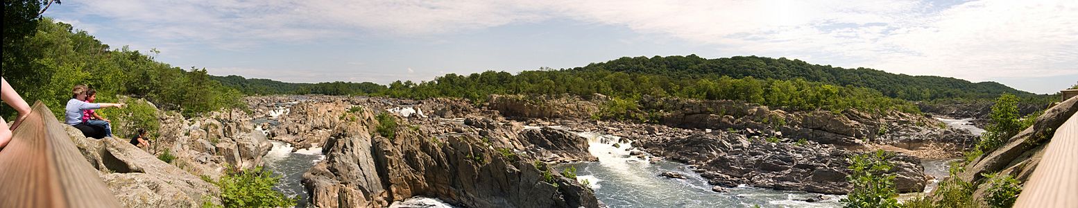
Great Falls panorama from Virginia
-
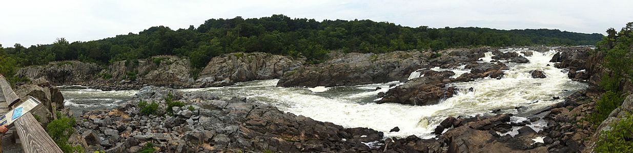
Great Falls panorama from Maryland

.jpg)
How Great Falls Formed
.jpg)
The rocks you see at Great Falls are super old, about 750 million years old! They formed during a time called the late Precambrian era. These rocks are very strong and hard. They are made of types of rock like schist and gneisses.
The falls themselves are much younger. They formed about 35,000 years ago during the Last Glacial Period. This was a time when sea levels dropped a lot. As the sea level went down, the Potomac River started to cut deeper into its valley, creating the falls we see today.
The river flows over a series of drops, each about 20 feet (6 meters) high. In total, the water drops about 76 feet (23 meters) over a distance of less than 1 mile (1.6 km).
If sea levels rise again in the future, the power of the falls might become weaker. This is because the water wouldn't have as far to drop. If the ocean level ever got higher than the falls, the falls would actually go underwater!
The Potomac River gets narrower as it goes over the falls and through a place called Mather Gorge. When there's a lot of rain or snow upstream, the river can flood. The water can get so high that it covers the rocks and even reaches the park visitor center, which is built on stilts to protect it. There's a special marker at the Virginia overlook that shows how high the water got during a huge flood in 1936.
Canals and Their Purpose
_at_approx_14.12_mi_for_Chesapeake_and_Ohio_Canal.jpg)
People built several canal systems around Great Falls a long time ago. Canals are like man-made rivers that help boats travel around difficult parts of a natural river, like waterfalls.
On the Virginia side, you can still see parts of the Patowmack Canal. This canal was built in the 1700s. George Washington himself helped plan it! It had five special sections called locks. Locks are like water elevators that let boats go up or down to different water levels, helping them get around the falls.
Later, in the early 1800s, the Chesapeake and Ohio Canal was built on the Maryland side. This canal eventually connected the Potomac River all the way to Cumberland, Maryland. The Chesapeake and Ohio Canal also used Great Falls to get water for its own use, through a special "feeder" channel that is now no longer used.
