
George Washington Memorial Parkway facts for kids
Quick facts for kids
[[File:|x70px|alt= marker]] |
|
|---|---|
| G.W. Parkway | |
| Route information | |
| Maintained by NPS | |
| Length | 24.9 mi (40.1 km) |
| Existed | May 29, 1930–present |
| Tourist routes |
|
| Restrictions | No commercial vehicles |
| Southern segment | |
| South end | |
| North end | |
| Northern segment | |
| South end | |
| Major junctions |
|
| North end | |
| Location | |
| States: | Virginia, District of Columbia |
| Highway system | |
| Numbered highways in Washington, D.C.Virginia Routes Primary • Secondary • History • Turnpikes |
|
The George Washington Memorial Parkway, also known as the G.W. Parkway, is a special road about 25 miles (40 km) long. It follows the south side of the Potomac River in Virginia, starting near Mount Vernon, Virginia and going northwest to McLean, Virginia. The National Park Service (NPS) takes care of it. Most of the parkway is in Virginia. A small part goes through Columbia Island in Washington, D.C., near the Arlington Memorial Bridge.
The parkway has two main parts. These parts are connected by Washington Street (State Route 400) in Alexandria. There's also a related road called the Clara Barton Parkway. This road is on the other side of the Potomac River in Washington, D.C. and Montgomery County, Maryland. The George Washington Memorial Parkway is so special that it's called an All-American Road. In Virginia, its official state number is State Route 90005.
Contents
Exploring the Parkway
The George Washington Memorial Parkway is divided into two main sections. These sections offer different views and attractions.
Southern Section: Mount Vernon to Alexandria
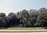
_in_Mount_Vernon,_Fairfax_County,_Virginia.jpg)
The southern part of the parkway starts in Mount Vernon, Virginia. It begins at a traffic circle where it meets SR 235. Much of this road was built on old railway land. This section is like a highway, but it has some intersections where you stop for cross-traffic.
It goes from Mount Vernon, past Fort Hunt, to South Washington Street in Alexandria. The Mount Vernon Trail runs next to this part of the parkway. It's a popular path for people who like to bike or run.
Along this section, you can see many interesting places. These include Mount Vernon Plantation, Fort Hunt Park, Dyke Marsh, and the Woodrow Wilson Bridge.
Washington Street in Alexandria is part of the parkway, but the City of Alexandria still takes care of it. In 1929, the city and the government agreed to work together. They wanted to make sure buildings along Washington Street looked nice and fit the parkway's special memorial purpose.
Big trucks are not allowed on the George Washington Memorial Parkway. However, taxis and airport shuttles can use it.
Northern Section: Alexandria to McLean
_in_McLean,_Fairfax_County,_Virginia.jpg)
The northern part of the parkway begins in North Old Town Alexandria. It ends at Interstate 495 (the Capital Beltway) in Fairfax County. This section follows the Potomac River. It goes through Arlington County.
This part of the parkway is the main way to get to Ronald Reagan Washington National Airport. You can also use it to reach places like Theodore Roosevelt Island, the LBJ National Grove, and Gravelly Point Park. There are special spots where you can stop to enjoy views of the Georgetown skyline and the Potomac Palisades.
An old cloverleaf interchange near the 14th Street Bridge was built in 1932. It is one of the oldest of its kind in the United States. The Spout Run Parkway connects the George Washington Memorial Parkway to US Route 29. This gives you a way to get to I-66. The part of the parkway north of the airport is part of the National Highway System.

History of the Parkway
The idea for the George Washington Memorial Parkway started a long time ago. People wanted an easy way to visit George Washington's home at Mount Vernon. They saw it as a way to learn about American history.
Early Ideas for a Road
In the late 1800s, people in Alexandria, Virginia, wanted a "national road" to Mount Vernon. They thought it would help local businesses. In 1889, Congress paid for a study. The United States Army Corps of Engineers agreed that a great road was needed. However, a cheaper trolley system built in the 1890s slowed down these plans.
Around 1899, the idea of a road to Mount Vernon came back. Many people who wanted to improve cities and preserve history liked the idea. They imagined a grand road with beautiful buildings and memorials. The Daughters of the American Revolution also supported the project. In 1902, the McMillan Plan suggested a road along the Virginia side of the Potomac River. This plan wanted tree-lined roads and quiet paths for relaxation.
Building the Memorial Highway
The Bureau of Public Roads (BPR) took over the idea in the 1920s. They wanted to show off new road-building technology. They first suggested simple upgrades, but soon planned a more detailed road. This new plan included special plantings, historic stops, and scenic overlooks.
As George Washington's 200th birthday approached in 1932, the BPR pushed their idea even more. They called it a "memorial highway" to honor Washington. They published books, showed models, and even made a film to get public support.
Groups like the American Civic Association said that the existing roads to Mount Vernon were ugly. They had too many billboards and tourist traps. This helped convince Congress that a new, beautiful road was needed. In 1924, a bill was introduced to build a memorial highway. It didn't pass that year.
Another bill was introduced in 1926. The BPR then suggested building the road along the river's edge. This route was flatter and had fewer intersections. It was more expensive, but many groups supported it.
The Mount Vernon Memorial Highway of 1928
|
Mount Vernon Memorial Highway
|
|
| Lua error in Module:Location_map at line 420: attempt to index field 'wikibase' (a nil value). | |
| Location | Washington St. and George Washington Memorial Pkwy., Washington, DC |
|---|---|
| Area | 515 acres (208 ha) |
| Built | 1929-1970 |
| Architect | US Bureau of Public Roads |
| NRHP reference No. | 81000079 |
| Significant dates | |
| Added to NRHP | May 18, 1981 |

In 1928, bills were introduced to build a memorial highway from Arlington Memorial Bridge to Mount Vernon. It would cost $4.5 million. The Washington Bicentennial Commission would manage the project. President Calvin Coolidge and many other groups supported the idea.
Some people worried about the cost and if a highway was the best way to honor George Washington. Others worried about damage to the environment. But the idea of honoring Washington won out. The House of Representatives voted for the bill on May 22, 1928. President Coolidge signed it into law on May 24. This law was called "An act to authorize and direct the survey, construction, and maintenance of a memorial highway to connect Mount Vernon, in the State of Virginia, with the Arlington Memorial Bridge across the Potomac River at Washington."
Becoming the Current Parkway
The road was first called the Mount Vernon Memorial Highway. But in 1930, Congress changed its name to the George Washington Memorial Parkway. They also decided to extend it to the Great Falls of the Potomac River. This idea came from Representative Cramton.
Congress passed the "Act of May 29, 1930," also known as the Capper-Cramton Act. This law set aside $13.5 million to buy land and build the parkway. It would go from Mount Vernon to the Great Falls on the Virginia side. It also planned for a parkway on the Maryland side and a bridge across the Potomac at Great Falls.
The George Washington Memorial Parkway was built in different parts between 1929 and 1970. The first part, the Mount Vernon Memorial Highway, was finished in 1932. It went from Arlington Memorial Bridge to Mount Vernon.
President Herbert Hoover informally opened this section on January 16, 1932. He was the first person to drive on it. This was part of the celebration for Washington's 200th birthday. At first, the road was only open on weekends during the day. It opened for day and night use on May 6, 1932.
The northern parts of the parkway were mostly finished in the 1950s and 1960s. A section from Glebe Road to I-495 was built to help workers get to the new Central Intelligence Agency headquarters in Langley, Virginia. Some parts of the parkway were seen as excellent examples of modern road design.
Over time, more areas were added to the parkway system. These include Memorial Drive near Arlington National Cemetery and the LBJ Memorial Grove on Columbia Island.
How the Parkway is Managed

The parkway was officially created on May 29, 1930. On November 28, 1989, the part of the parkway in Maryland was renamed the Clara Barton Parkway. This was done to avoid confusion with the main parkway in Virginia.
The parkway also manages other important National Park Service sites nearby. These include:
- Arlington House, The Robert E. Lee Memorial
- Arlington Memorial Bridge & Avenue
- Arlington Ridge Park
- Belle Haven Park & Marina
- Clara Barton National Historic Site
- Clara Barton Parkway
- Claude Moore Colonial Farm
- Collingwood Picnic Area
- Columbia Island Marina
- Daingerfield Island
- Dyke Marsh Wildlife Preserve
- Fort Hunt Park
- Fort Marcy Park
- Glen Echo Park
- Gravelly Point
- Great Falls Park
- Jones Point Park & Lighthouse
- Lady Bird Johnson Park
- Lyndon Baines Johnson Memorial Grove on the Potomac
- Mount Vernon Trail
- Navy – Merchant Marine Memorial
- Netherlands Carillon
- Potomac Heritage Trail
- Riverside Park
- Roaches Run Waterfowl Sanctuary
- Spout Run Parkway
- Theodore Roosevelt Island
- Turkey Run Park
- U.S. Marine Corps War Memorial (Iwo Jima Memorial)
- Washington Sailing Marina
- Women in Military Service for America Memorial
You can find information and maps at the Parkway headquarters in McLean, Virginia. The US Park Police are the main police agency that patrols the George Washington Parkway and these other areas.
Proposed Connections That Weren't Built

The Clara Barton Parkway is managed as part of the George Washington Memorial Parkway. It used to have the same name until 1989.
The original plan was to connect the parkways on both sides of the river with a bridge at the Great Falls. But people who wanted to protect the environment stopped this plan. Instead, cars use the American Legion Bridge to cross the river. The Virginia side of the Great Falls is now a national park site called Great Falls Park. Some parts of the planned bridge were built but were never used.
Major Intersections
| County | Location | Mile | Roads intersected | Notes | ||
|---|---|---|---|---|---|---|
| Fairfax | Mount Vernon | 0.0 | Traffic circle | |||
| Fort Hunt | 2.7 | 4.3 | Fort Hunt Road – Fort Hunt Park | |||
| Hunting Creek | 8.4 | 13.5 | Bridge; southern terminus of SR 400 | |||
| City of Alexandria | 9.3 | 15.0 | Eastern terminus of SR 236, Duke Street continues east | |||
| 9.5 | 15.3 | Eastern terminus of SR 7, King Street continues east | ||||
| 10.2 | 16.4 | First Street / Abingdon Drive | At-grade intersection; northern terminus of SR 400 | |||
| Four Mile Run | 10.1 | 16.3 | Bridge | |||
| Arlington | Crystal City | 12.5 | 20.1 | No northbound exit; via SR 233 | ||
| 13.2 | 21.2 | No southbound entrance; via West Entrance Road | ||||
| Long Bridge Park | 14.3 | Exits 10B-C on I-395 | ||||
| District of Columbia | Washington (Columbia Island) |
14.7– 15.6 |
23.7– 25.1 |
US 50 not signed southbound | ||
| 15.4 | No direct northbound exit | |||||
| Virginia | Arlington | Rosslyn | 16.1 | 25.9 | Southbound exit and northbound entrance to I-66 / US 50 east; no northbound exit to US 50 west | |
| 16.8 | 27.0 | Southbound exit and northbound entrance | ||||
| North Highland | 17.4 | 28.0 | Northbound exit and southbound entrance | |||
| Fairfax | McLean | 21.5 | 34.6 | |||
| 23.0 | 37.0 | George Bush Center for Intelligence, CIA, FHWA | ||||
| 23.5 | 37.8 | I-495 not signed northbound; access to I-495 via u-turn | ||||
| 24.9 | 40.1 | Exit 43 on I-495 | ||||
| 1.000 mi = 1.609 km; 1.000 km = 0.621 mi | ||||||
Image Gallery
-
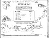
Schematic map of the George Washington Memorial Parkway (1994)
-
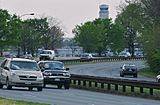
Vehicles round a bend in the parkway near Reagan-Washington National Airport and Gravelly Point in Arlington, Virginia
-
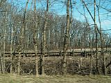
Portion of the Potomac Heritage Trail as it passes through marshland near Belle Haven
-
Clara Barton Parkway in Maryland
-
Houses along the parkway near Mount Vernon
-
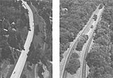
Aerial overview
-
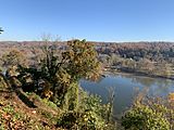
Scenic Overlook looking north on to The Palisades
-
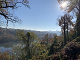
Scenic Overlook looking south onto Rosslyn


.JPG)


Images for kids
-
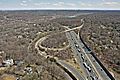
I-495 Interchange with the North Entrance to the George Washington Memorial Parkway
-
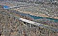
George Washington Memorial Parkway and the Chain Bridge
-
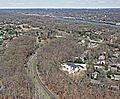
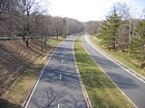
Looking NW at the North and South Bound Lanes of the George Washington Memorial Parkway
-
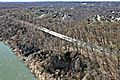
North and South Bound Lanes of the George Washington Memorial Parkway


