McLean, Virginia facts for kids
Quick facts for kids
McLean, Virginia
|
|
|---|---|

|
|

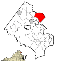
Location of McLean in Virginia (left) and in Fairfax County, Virginia (right)
|
|
| Country | |
| State | |
| County | Fairfax |
| Area | |
| • Total | 24.88 sq mi (64.4 km2) |
| • Land | 24.79 sq mi (64.2 km2) |
| • Water | 0.09 sq mi (0.23 km2) |
| Elevation | 285 ft (87 m) |
| Population
(2020)
|
|
| • Total | 50,773 |
| • Density | 2,040.7/sq mi (788.4/km2) |
| Time zone | UTC−5 (Eastern (EST)) |
| • Summer (DST) | UTC−4 (EDT) |
| ZIP Codes |
22101–22103, 22106
|
| Area codes | 571, 703 |
| FIPS code | 51-48376 |
| GNIS feature ID | 1495919 |
McLean (MƏ-klayn) is a community in Fairfax County, Virginia, United States. It is a "census-designated place" (CDP), which means it's an area identified by the United States Census Bureau for statistics, but it's not an officially incorporated city or town. In 2020, about 50,773 people lived there. McLean is located between the Potomac River and Vienna, close to Washington, D.C..
Many wealthy people live in McLean. This includes diplomats, military leaders, and government officials. This is because it is very close to Washington, D.C., the Pentagon, and the Central Intelligence Agency. McLean is known for its fancy homes and high-end shopping areas like Tysons Corner Center and Tysons Galleria. In 2022, McLean was ranked as the third wealthiest city in the United States. This was based on its low poverty rate and high average household income.
Contents
History of McLean
McLean got its name from John Roll McLean. He used to own The Washington Post newspaper. In 1902, he helped buy a railroad company called the Great Falls and Old Dominion Railroad. This railroad connected the area to Washington, D.C., starting in 1906.
John Roll McLean built a train station and named it after himself. This station was where the railroad crossed Chain Bridge Road. The community of McLean officially started in 1910. This happened when two smaller communities, Lewinsville and Langley, joined together.
Geography and Location
McLean is located in Northern Virginia, near the Capital Beltway (Interstate 495). It is about 8 miles (13 km) northwest of downtown Washington, D.C.. It is also about 9 miles (14 km) northeast of Fairfax, Virginia, which is the county seat.
The community is on the west bank of the Potomac River. The river forms McLean's northern and eastern borders. Several small streams flow through McLean into the Potomac River. These include Bull Neck Run, Scott Run, Dead Run, Turkey Run, and Pimmit Run.
McLean covers an area of about 24.88 square miles (64.4 square kilometers). Most of this area is land, with a small part being water. McLean is part of the larger Washington Metropolitan Area. It includes the communities of Langley, Lewinsville, and West McLean. It also borders other nearby places like Potomac, Maryland, Arlington, and Tysons. McLean has a warm, humid climate.
People of McLean
| Historical population | |||
|---|---|---|---|
| Census | Pop. | %± | |
| 1970 | 17,698 | — | |
| 1980 | 35,664 | 101.5% | |
| 1990 | 38,168 | 7.0% | |
| 2000 | 38,929 | 2.0% | |
| 2010 | 48,115 | 23.6% | |
| 2020 | 50,773 | 5.5% | |
| * U.S. Decennial Census | |||
In 2010, there were 48,115 people living in McLean. There were 17,063 households and 13,453 families. The population density was about 1,941 people per square mile (749 people per square kilometer).
Most of the people in McLean were White (79.3%). About 14.9% were Asian, and 1.8% were African American. About 4.9% of the population was Hispanic or Latino.
In 2010, about 39.6% of households had children under 18. Most households (70.5%) were married couples. The average age of people in McLean was 45.1 years old.
The average income for a household in McLean was $164,888. For families, the average income was $194,832. Only a small number of people (2.6%) lived below the poverty line.
Economy and Jobs
Many companies have their offices in McLean. These include Mars and Geebo. Also, many businesses in nearby Tysons use a McLean mailing address. This is because of how the postal service boundaries are set up.
In 2012, most adults (61.6%) in McLean were working or looking for jobs. A large number of people (73.2%) worked in management, business, science, and arts. Other jobs included sales, office work, and service occupations. Many people worked in professional services, healthcare, and public administration.
The cost of living in McLean is very high. For example, the average home value in 2012 was $908,000. Rent and mortgage costs were also much higher than the national average.
Parks and Fun Activities
McLean has a Little League baseball and softball program. In 2005, the girls' All-Star softball team from McLean Little League won the Little League Softball World Series Championship. They were also runners-up in 2004 and 2013.
Clemyjontri Park is a popular park in McLean that opened in 2006. It is known for being a very accessible playground for children of all abilities.
Education in McLean
Students in McLean attend schools in the Fairfax County Public Schools (FCPS) system.
Public Schools
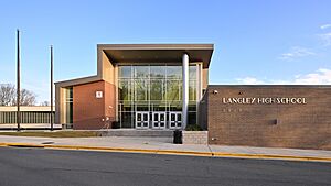
Several public elementary schools are located in McLean. These include Chesterbrook, Churchill Road, Haycock, Kent Gardens, Franklin Sherman, and Spring Hill. The public middle schools are James Fenimore Cooper Middle School and Henry Wadsworth Longfellow Middle School. The two public high schools are Langley High School and McLean High School.
Private Schools
McLean also has many private schools for different age groups. Some of these are The Langley School, The Madeira School, Potomac School, and Oakcrest School.
Colleges and Universities
There are several colleges and universities near McLean. Marymount University is in Arlington. The University of Virginia has a center in nearby Falls Church. George Mason University is about 9 miles southwest. Other universities like American University, Georgetown University, and George Washington University are in Washington, D.C.
Libraries and Weekend Programs
The Fairfax County Public Library operates the Dolley Madison Library in McLean.
Some weekend educational programs are also held in McLean. The Washington Japanese Language School used to have classes at St. Luke Catholic School. The Polish School of Washington, D.C., holds classes at Longfellow Middle School. A Brazilian Portuguese language program also has classes at McLean High School.
Transportation in McLean
Roads and Highways
Several major roads and highways pass through McLean. These include the Capital Beltway (Interstate 495), the George Washington Memorial Parkway, and the Dulles Access Road. Other important roads are Dolley Madison Boulevard and Georgetown Pike.
Public Transport
The Washington Metro subway system serves McLean. The Silver Line has a station called McLean station. This station is about two miles west of downtown McLean. Other nearby Metro stations include West Falls Church and Tysons.
Both WMATA (Metrobus) and Fairfax Connector offer bus services in McLean. These bus routes connect different parts of McLean, including the Metro station.
Famous People from McLean
Many well-known people have lived in McLean. Some of them include:
- Joe Biden and Jill Biden, the 46th U.S. President and First Lady.
- Dick Cheney, a former U.S. Vice President.
- Robert Byrd, a very long-serving U.S. Senator.
- Newt Gingrich, a former Speaker of the House of Representatives.
- Anthony Kennedy, a former justice on the U.S. Supreme Court.
- Alexander Ovechkin, a famous professional ice hockey player for the Washington Capitals.
- Bradley Beal, a professional basketball player for the Phoenix Suns.
- Gore Vidal, a well-known author.
See also
 In Spanish: McLean (Virginia) para niños
 | James Van Der Zee |
 | Alma Thomas |
 | Ellis Wilson |
 | Margaret Taylor-Burroughs |


