Columbia Island (District of Columbia) facts for kids

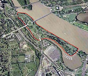
Aerial view of Columbia Island (outlined in red)
|
|
| Geography | |
|---|---|
| Location | Potomac River, Washington, D.C. |
| Coordinates | 38°52′56″N 77°03′26″W / 38.8823342°N 77.0571996°W |
| Total islands | 1 |
| Area | 0.19 sq mi (0.49 km2) |
| Length | 1.32 mi (2.12 km) |
| Coastline | 2.95 mi (4.75 km) |
| Highest elevation | 22 ft (6.7 m) |
| Administration | |
|
United States
|
|
| Demographics | |
| Population | 0 |
Columbia Island is a special island in the Potomac River in Washington, D.C., USA. It's unique because it's partly natural and partly man-made! The island was first named "Columbia Island" around 1918. Later, in 1968, it was renamed Lady Bird Johnson Park to honor the former First Lady.
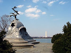
Today, the park is home to the Lyndon Baines Johnson Memorial Grove, the Navy – Merchant Marine Memorial, and the Columbia Island Marina. These places are all part of the George Washington Memorial Parkway and are looked after by the National Park Service.
Contents
How Columbia Island Was Made
Columbia Island didn't always exist as it does today. In the early 1800s, it was connected to Analostan Island. Over time, the river's natural flow and floods slowly separated it.
Between 1911 and 1927, the U.S. government started a big project. They used special machines to dig up (or "dredge") material from the bottom of the Potomac River. This material was then piled onto the island. This process helped to make the island bigger, longer, and higher, giving it its current shape.
The island got its name, "Columbia Island," around 1918. It was officially transferred to the National Park Service in 1922.
Building Up Columbia Island
Arlington Memorial Bridge and Island Expansion
In 1922, plans began for a very important bridge: the Arlington Memorial Bridge. This bridge would connect Washington, D.C., with Arlington National Cemetery in Virginia. The bridge designers realized that Columbia Island needed to be much larger to support the bridge's connections.
So, in 1925, the United States Army Corps of Engineers started another big dredging project. They removed a huge amount of river bottom material and used it to expand Columbia Island even more. They also built a strong wall around the island to protect it. The goal was to raise the island's height to 22 feet (about 6.7 meters) above the water.
Early Ideas for Columbia Island
Many people and groups had ideas for how Columbia Island should look. They wanted it to be a grand entrance to Washington, D.C. Early plans included traffic circles, large columns representing the North and South, and statues.
By 1927, the dredging and reshaping of the island were mostly finished. It had grown to about 200 acres (81 hectares) and was 22 feet (6.7 meters) high.
Building the Boundary Channel Bridge
Work began on the Boundary Channel Bridge in 1929. This bridge would connect Columbia Island to Virginia, leading to Memorial Drive and Arlington National Cemetery. Building it was tricky because of unstable ground, but engineers worked through the challenges.
By 1930, the main part of the Arlington Memorial Bridge was almost done. However, the plans for Columbia Island's central area, with its grand plaza and columns, were still being debated.
Changes to the Main Plaza
The Great Depression, a time of economic hardship in the 1930s, affected funding for the island's development. To save money, many of the grand plans, like Greek Revival temples and statues, were removed from the design.
Also, the island needed more filling to make sure it was stable. In late 1930, more dredged material was added to raise the island even higher, aiming for 30 feet (9.1 meters) above water.
Removing the Tall Columns
A big change happened in 1931. The original plans for Columbia Island included two very tall memorial columns. However, these columns were a problem for airplanes! There were two airfields nearby, and the tall columns would make it dangerous for planes to take off and land.
President Herbert Hoover got involved. After many discussions and protests from pilots and aviation groups, the idea of the tall columns was finally dropped in December 1931. This decision saved a lot of money and made the area safer for air travel.
Finishing Columbia Island
By April 1932, the Boundary Channel Bridge was mostly complete. However, funding problems almost stopped all work on Columbia Island.
When Franklin D. Roosevelt became president in 1933, he started a program called the Public Works Administration (PWA) to create jobs and build important projects. In July 1933, the PWA provided $3 million to finish Columbia Island and the Arlington Memorial Bridge project.
This money helped build new bridges on the north and south ends of the island. These bridges would connect to other roads in Virginia. Roads were also built across Columbia Island. By 1940, the island had a "racetrack" feature – a larger outer traffic circle – to help manage the increasing traffic.
Columbia Island's Later Years
Over the years, Columbia Island continued to be improved. In the 1940s, more bridges were built or widened to handle growing traffic, especially with the expansion of the The Pentagon.
In the 1960s and 1970s, the National Park Service worked to make Columbia Island even more beautiful. They added a footbridge and a parking lot. In 1987, the South Washington Boulevard bridge was repaved.
A major project started in 2008 to rebuild the "Humpback Bridge," which connects the island to Virginia. This bridge was widened and improved to handle more cars. It also got an underpass for people walking and biking, connecting the Columbia Island Marina and the LBJ Memorial Grove to the Mount Vernon Trail. This project was finished in 2011.
In 2008, a children's garden was also built on Columbia Island, making it an even more family-friendly place.
For a long time, there was no memorial in Washington, D.C., to honor the brave men and women of the United States Navy and the United States Merchant Marine. In the 1920s, Congress decided to build one.
Ground was broken for the memorial in 1930, but it took many years to raise enough money. The statue was finally put in place in 1934. With help from the Works Progress Administration, the memorial was completed in 1939. This included adding special wavy green granite steps and landscaping the area around it.
Lady Bird Johnson Park
On November 12, 1968, Columbia Island was officially renamed Lady Bird Johnson Park. This was done to honor Lady Bird Johnson, the First Lady at the time. She was famous for leading a big campaign to make cities and towns across the country more beautiful.
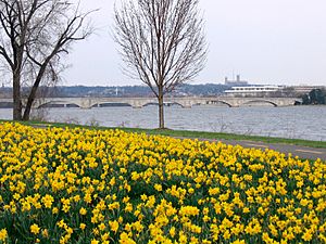
When the island was renamed, many new plants were added. Between 1965 and 1968, over a million daffodils and 2,700 dogwood trees were planted. These beautiful flowers and trees were paid for by various groups, including the National Park Service.
Lyndon Baines Johnson Memorial Grove
After former President Lyndon B. Johnson passed away in 1973, people wanted to create a memorial for him. Instead of a statue, they decided on a peaceful grove of trees. Lady Bird Johnson Park was chosen because President Johnson loved the park.
The memorial grove was designed by landscape architect Meade Palmer. It covers about 15 acres (6.1 hectares) and features a quiet meadow and a granite plaza among trees like white pines and dogwoods. A special 19-foot (5.8-meter) tall pink granite stone, called an "orthostat," was brought from Texas and placed in the center. This stone has a rough, natural look, like President Johnson's personality.
Four quotes from Johnson's speeches, chosen by Lady Bird Johnson, are carved into stones around the orthostat. The memorial was officially dedicated on April 6, 1976.
About the Island
Columbia Island is separated from the Virginia shoreline by the Boundary Channel. The main part of the Potomac River flows around its other sides. In 2007, the island had 121 acres (49 hectares) of beautiful parkland.
You can reach Columbia Island from downtown Washington by crossing the Arlington Memorial Bridge. You can also get there from Arlington National Cemetery via Memorial Drive, or from Northern Virginia using the George Washington Memorial Parkway.
The Mount Vernon Trail, a popular path for walking and biking, runs along the side of the island facing Washington, D.C. From the island, you can see The Pentagon near the marina at the southern tip.
In Popular Culture
Columbia Island is a popular setting for authors in their fiction books. It's mentioned in books like Anthony S. Policastro's Dark End of the Spectrum and S.R. Larson's America Occupied.
The Columbia Island Marina and the Boundary Channel also appear in novels such as Sean Flannery's Moving Targets and Kim Stanley Robinson's Forty Signs of Rain.
See also
 In Spanish: Isla Columbia (Distrito de Columbia) para niños
 | Georgia Louise Harris Brown |
 | Julian Abele |
 | Norma Merrick Sklarek |
 | William Sidney Pittman |


