
Theodore Roosevelt Island facts for kids
Quick facts for kids Theodore Roosevelt Island National Memorial |
|
|---|---|
|
IUCN Category III (Natural Monument)
|
|

17-foot Centerpiece Statue
|
|

Theodore Roosevelt Island National Memorial
Location in Washington, D.C.

Theodore Roosevelt Island National Memorial
Location in the United States
|
|
| Location | The Potomac River in Washington, D.C., U.S. |
| Area | 88.5 acres (35.8 ha) |
| Max. elevation | 44 feet (13 m) |
| Established | May 21, 1932 |
| Visitors | 160,000 (in 2015) |
| Governing body | National Park Service |
| Website | Theodore Roosevelt Island |
Theodore Roosevelt Island is a special place in the Potomac River in Washington, D.C.. It's an island that covers about 88.5 acres (35.8 hectares). This island is a national memorial that honors Theodore Roosevelt. He was the 26th president of the United States.
The Theodore Roosevelt Association gave the island to the U.S. government. They wanted to create a lasting memory of President Roosevelt. Before it became a memorial, the island had many different names. Some of these names were My Lord's Island, Barbadoes Island, and Mason's Island.
Today, the National Park Service takes care of the island. It's kept as a natural park with many trails. There's also a special memorial area with a large statue of Roosevelt. You can't bring cars or bikes onto the island. You can only get there by walking across a footbridge from Arlington, Virginia.
Landscape architects worked on the island in the 1930s. They turned old farmland into a "real forest." This forest was designed to look like the natural woods that once grew there. Now, you can explore miles of trails. These trails go through forests and wet, swampy areas. They help us remember Roosevelt, who loved the outdoors and protecting nature.
A smaller island, called "Little Island," is near the southern tip. Across the main part of the Potomac River are Georgetown and the John F. Kennedy Center for the Performing Arts.
Contents
Island's Past: A Look at Its History
The Nacotchtank Native American people lived on the island for a short time in 1668. They called it "Anacostine." This is the first name we know for the island. Later, in 1682, Captain Randolph Brandt officially claimed the island. He also called it Anacostine Island.
The island was bought by George Mason III in 1724. His son, George Mason IV, took over the island in 1735. Then, John Mason, George Mason IV's son, owned it from 1792 to 1833. John Mason built a large house around 1796. He also created beautiful gardens on the island in the early 1800s. The Mason family left the island in 1831. This was because a causeway (a raised road over water) caused the water around the island to become still and unhealthy.
After John Mason passed away in 1842, the island changed hands several times. From 1913 to 1931, the Washington Gas Light Company owned it. During this time, plants grew wild and unchecked. By 1935, a group called the Civilian Conservation Corps cleared much of the island. They also took down the last parts of the old Mason house. Today, you can only see a small part of the house's foundation.
During the American Civil War, the island was used as a training camp. The 1st United States Colored Infantry trained there in 1863. This was a unit made up of African American soldiers. From 1864 to 1865, the camp also housed up to 1,200 "Contraband (American Civil War)." These were formerly enslaved people who had escaped to the Union Army. Locals still called it "Mason's Island" until the memorial was built.
Theodore Roosevelt National Memorial

In 1931, the Theodore Roosevelt Memorial Association bought the island. They wanted to build a memorial to honor President Roosevelt. The U.S. Congress agreed to the memorial on May 21, 1932. However, it took almost 30 years for them to provide the money.
Finally, Congress set aside funds in 1960. The memorial is now listed on the National Register of Historic Places. This means it's an important historical site. It was first added to the list on October 15, 1966.
The memorial was officially opened on October 27, 1967. It was designed by Eric Gugler. The memorial features a large 17-foot (5 meter) statue of Roosevelt. This impressive statue was created by sculptor Paul Manship. There are also four big stone blocks with famous quotes from Roosevelt. Two large fountains add to the beauty of the memorial.
Nature and Geography of the Island
The Potomac River around the island is at sea level. It's part of the Chesapeake Bay estuary, where fresh river water mixes with salty ocean water. The water here is fresh, but it still has tides. A small channel, sometimes called "Little River," separates the island from the Virginia side. The main part of the Potomac is between the island and Georgetown.
The island is entirely within the District of Columbia. This is true even though you access it from Virginia. The western and central parts of the island are rocky. They are part of the Piedmont Plateau. The southeastern part is flatter and belongs to the Atlantic Coastal Plain. You can even see where these two different land areas meet. The island has about 2.5 miles (4 km) of shoreline. The highest point, where the old Mason house stood, is about 44 feet (13 meters) above sea level.
Floods from the Potomac River happen often, especially in spring. These floods come from the Appalachian Mountains. They cover the lower parts of the island's shores many times a year. Larger floods, often from hurricanes, can cover the island more deeply.
The island has many different types of plants. This is because of its varied land, frequent floods, and history. Most of the island is covered in deciduous forest. This means trees that lose their leaves in the fall. There are forests on the higher lands, along the riverbanks, and in swamps. There's also a freshwater marsh area. You can even see some bedrock (solid rock) sticking out of the ground. The different types of habitats along the island's shores are very special.
The island is well-known for its many kinds of birds. It also has beautiful displays of spring wildflowers. However, many non-native plants have grown there. These plants often take over and push out the native plants.
How to Get to the Island

You can get to Theodore Roosevelt Island by walking across a footbridge. This bridge connects to a parking lot on the Virginia side of the Potomac River. The parking lot is just north of the Theodore Roosevelt Bridge. This bridge goes over the island but doesn't let you get on it. You can only enter the parking lot from the northbound lanes of the George Washington Memorial Parkway.
If you are walking or biking, you can reach the parking lot and footbridge. Follow the Mount Vernon Trail south from the intersection of Lee Highway and N. Lynn St. in Rosslyn. This is close to the Key Bridge. The closest Washington Metro subway station is the Rosslyn station.
Once on the island, you can explore several hiking trails. These trails lead to the memorial and different natural areas. There's even a boardwalk that goes through a swampy and marshy part of the island.
Images for kids
-
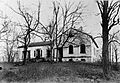
The Mason House in the 19th Century
-
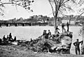
Union soldiers on the island in 1861
-
Contraband Quarters, Mason's Island


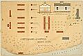
_Island,_Washington,_D.C._(Ground_plan,_view_and_cross_section_of_one_of_the..._-_NARA_-_305820.jpg)
See also
 In Spanish: Isla Theodore Roosevelt para niños
