Atlantic coastal plain facts for kids

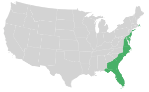
The Atlantic Plain is one of eight main land regions in the United States. It stretches along the Atlantic Coast. This area includes states like Delaware, Florida, Georgia, Maine, Maryland, New Jersey, New York, North Carolina, South Carolina, Virginia, and Puerto Rico.
The land near the Atlantic Ocean has sandy beaches, marshlands, bays, and barrier islands. This large region includes the Continental Shelf and the Coastal Plain. It is the flattest part of the U.S. land regions. The Atlantic Plain is about 2,200 miles (3,500 km) long. It goes from Cape Cod all the way to the Mexican border. It also extends another 1,000 miles (1,600 km) south to the Yucatán Peninsula.
The central and southern parts of the Atlantic Coast have many barrier islands. They also have coasts where river valleys have been "drowned" by rising sea levels. The Atlantic Plain has almost continuous barriers. These are broken up by inlets, which are narrow waterways. It also has large bays with drowned river valleys. You can find many wetlands and marshes here too. The plain gently slopes towards the sea from the higher lands inland. This slope continues far into the Atlantic Ocean and the Gulf of Mexico. This forms the continental shelf. The land and sea often blend together. This is especially true in places like the Louisiana bayous and the Florida Everglades.
What is the Coastal Plain?
The Coastal Plain is a major part of the Atlantic Plain. It includes several sections. These are the Embayed, Sea Island, Floridian, East Gulf Coastal Plain, Mississippi Alluvial Plain, and West Gulf Coastal Plain. The ground here is mostly made of sand and clay. These materials have not yet turned into harder rock like sandstone.
This coastal area has many continuous barriers. These are separated by inlets. There are also large bays with drowned river valleys. You will find many wetlands and marshes here. The Atlantic Plain gently slopes towards the sea. It does this in a series of flat steps. The surface of the land is mostly flat. Many people live in this area. The large number of people can affect the local wildlife.
The Coastal Plain stretches for about 2,200 miles (3,500 km). It goes from the New York Bight south to a part of Georgia and Florida. This area separates it from the ACF River Basin to the west. The plain is bordered by the Atlantic Seaboard Fall Line and the Piedmont plateau to the west. The Atlantic Ocean is to its east. The Floridian province is to its south. The Outer Lands are a group of islands. They form the far northeastern end of the Atlantic coastal plain.
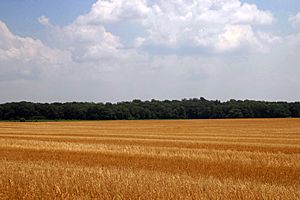
The average height of this area is less than 900 meters above sea level. It reaches about 50 to 100 kilometers inland from the ocean. The coastal plain is usually wet. It has many rivers, marshes, and swamps. It is mostly made of sedimentary rock and loose sediments. This land is mainly used for agriculture, which means farming. The Atlantic Coastal Plain includes the Carolina Sandhills region. It also has the Embayed and Sea Island areas. Sometimes, the Atlantic Coastal Plain is divided into northern and southern parts. These are called the Mid-Atlantic and South Atlantic coastal plains.
How Was the Atlantic Plain Formed?
The Atlantic Plain is generally made of layers of Mesozoic and Cenozoic sediments. These layers are gently sloped and have not been folded or broken. The layers of sediment get thicker as they go towards the sea. They can reach a thickness of about 3 kilometers (10,000 ft). This is especially true near Cape Hatteras, North Carolina.
See also
 In Spanish: Llanura atlántica para niños
 | Shirley Ann Jackson |
 | Garett Morgan |
 | J. Ernest Wilkins Jr. |
 | Elijah McCoy |


