
Centreville, Maryland facts for kids
Quick facts for kids
Centreville, Maryland
|
|||
|---|---|---|---|

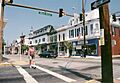
Intersection of Commerce and Water Street
|
|||
|
|||

Location in Queen Anne's County and the state of Maryland
|
|||

Centreville, Maryland
Location in Maryland

Centreville, Maryland
Location in the United States
|
|||
| Country | United States | ||
| State | Maryland | ||
| County | Queen Anne's | ||
| Incorporated | 1794 | ||
| Area | |||
| • Total | 2.74 sq mi (7.09 km2) | ||
| • Land | 2.74 sq mi (7.09 km2) | ||
| • Water | 0.00 sq mi (0.00 km2) | ||
| Elevation | 49 ft (15 m) | ||
| Population
(2020)
|
|||
| • Total | 4,727 | ||
| • Density | 1,727.07/sq mi (666.74/km2) | ||
| Time zone | UTC−5 (Eastern (EST)) | ||
| • Summer (DST) | UTC−4 (EDT) | ||
| ZIP code |
21617
|
||
| Area code | 410 | ||
| FIPS code | 24-14950 | ||
| GNIS feature ID | 0597212 | ||


Centreville is a cool town located in Queen Anne's County, Maryland. It's on a special piece of land called the Delmarva Peninsula. It became an official town in 1794 and is the main town, or "county seat," for Queen Anne's County. In 2020, about 4,727 people lived there. Its ZIP code is 21617, and phone numbers start with 410 or 443. Every summer, Centreville hosts the fun Queen Anne's County Fair. It was also once home to baseball teams like the Colts, Red Sox, and Orioles!
Contents
Where is Centreville?
Centreville is located at 39°2′46″N 76°3′52″W / 39.04611°N 76.06444°W. The town covers an area of about 2.74 square miles (7.09 square kilometers), and it's all land.

What's the Weather Like?
The weather in Centreville usually has hot and humid summers. Winters are generally mild to cool. This type of weather is called a humid subtropical climate. It means there's plenty of rain all year, and it doesn't get too cold in winter.
How Many People Live Here?
Centreville has grown a lot over the years! Here's how the population has changed:
| Historical population | |||
|---|---|---|---|
| Census | Pop. | %± | |
| 1870 | 915 | — | |
| 1880 | 1,196 | 30.7% | |
| 1890 | 1,309 | 9.4% | |
| 1900 | 1,231 | −6.0% | |
| 1910 | 1,435 | 16.6% | |
| 1920 | 1,765 | 23.0% | |
| 1930 | 1,291 | −26.9% | |
| 1940 | 1,141 | −11.6% | |
| 1950 | 1,804 | 58.1% | |
| 1960 | 1,863 | 3.3% | |
| 1970 | 1,853 | −0.5% | |
| 1980 | 2,018 | 8.9% | |
| 1990 | 2,097 | 3.9% | |
| 2000 | 1,970 | −6.1% | |
| 2010 | 4,285 | 117.5% | |
| 2020 | 4,727 | 10.3% | |
| U.S. Decennial Census | |||
In 2010, there were 4,285 people living in Centreville. Most residents were White, but there were also many African American, Asian, Native American, and other people. About 2.7% of the population was Hispanic or Latino. The average age was about 39.5 years old. Many families with children lived in the town.
A Look at Centreville's History
Centreville got its name because it became the "center" of Queen Anne's County. In 1782, the county decided to move its main government offices and courthouse from Queenstown to a more central spot.
Becoming the County Seat
It took about ten years to get everything ready. A large piece of land called Chesterfield was chosen for the new town. Once the courthouse was finished, in 1796, it officially became the main courthouse for Queen Anne's County.
The town of Centreville was officially created in 1794. This was two years after the new courthouse was built. Four of the streets laid out back then are still used today: MD 213, S. Liberty St., N. Commerce St., and Water St. (MD 304).
Centreville was also chosen because of its great spot on the Corsica River. Being close to the water made it easy for ships to come and go. This helped the town grow and become an important place in Maryland for trade and business.
Centreville Today
Today, Centreville is the biggest town in Queen Anne's County. Its history can be seen in the different styles of buildings around town. You can find old Victorian homes, classic public buildings, and newer structures.
Many parts of Centreville are so historic that they were added to the National Register of Historic Places in 2004. This means they are protected because of their special history.
Several other important historic places in the area are also on the National Register. These include Bachelor's Hope, Captain's Houses, Centreville Armory, and Content.
Famous Artists from Centreville
Centreville was home to two famous American Impressionist painters: Charles M. West and Anne Warner West. Charles was born in Centreville. He studied art in Philadelphia, where he met Anne. The West Gallery has many of their paintings. These artworks often show local scenes, like watermen working, historic buildings, and daily life in Centreville.
Charles West also taught art at Washington College. He is well-known for his painting called "The Narrows." This painting was even shown alongside works by famous artists like Edward Hopper and Georgia O'Keeffe.
_at_Maryland_State_Route_18_(4-H_Park_Road)_in_Centreville,_Queen_Anne%27s_County,_Maryland.jpg)
Getting Around Centreville
Most people travel to and from Centreville by road. Four main state highways serve the town. Maryland Route 213 is the most important road, connecting local communities along the eastern shore of the Chesapeake Bay. Other state highways include Maryland Route 18, Maryland Route 304, and Maryland Route 305. If you want to travel to bigger cities like Philadelphia or Washington D.C., U.S. Route 301 is a fast highway nearby.
The Historic Courthouse
The Queen Anne's County Courthouse in Centreville is very special. It's the oldest courthouse in Maryland that is still being used today! It's also one of only two courthouses in Maryland from the 1700s.
Building the Courthouse
The courthouse was finished in 1792. It was built with special bricks in a style called Flemish-bond. Originally, it had four rooms. As the town grew, the courthouse needed more space. So, in 1876, it was updated and made bigger. An iron balcony was also added to the second floor.
The Golden Eagle
A unique part of the courthouse is a golden eagle on its rooftop. This eagle is believed to represent America's freedom from England and the idea of independence. Judge John W. Sause, Jr., wrote about the eagle. He said it "looked down upon the comings and going of the courtyard, the tears and smiles of its citizens." It represents the political system and freedom.
Queen Anne's Statue
In front of the courthouse, there is a statue of Queen Anne of England. The county is named after her! In 1977, Princess Anne, who is the daughter of Queen Elizabeth II, even came to the dedication ceremony for the statue.
Today, the courthouse is still a very important building for Centreville, Queen Anne's County, and the state of Maryland. It still looks much like it did when it was first built.
Images for kids
-
Intersection of Commerce and Water Street
-

Flag of Centreville, Maryland
-

Seal of Centreville, Maryland
-

Location in Queen Anne's County and the state of Maryland
See also
 In Spanish: Centreville (Maryland) para niños
