
Queen Anne's County, Maryland facts for kids
Quick facts for kids
Queen Anne's County
|
|||
|---|---|---|---|

Queen Anne's County Courthouse in Centreville, Maryland
|
|||
|
|||

Location within the U.S. state of Maryland
|
|||
 Maryland's location within the U.S. |
|||
| Country | |||
| State | |||
| Founded | 1706 | ||
| Named for | Queen Anne | ||
| Seat | Centreville | ||
| Largest community | Stevensville | ||
| Area | |||
| • Total | 511 sq mi (1,320 km2) | ||
| • Land | 372 sq mi (960 km2) | ||
| • Water | 139 sq mi (360 km2) 27% | ||
| Population
(2020)
|
|||
| • Total | 49,874 | ||
| • Density | 97.60/sq mi (37.68/km2) | ||
| Time zone | UTC−5 (Eastern) | ||
| • Summer (DST) | UTC−4 (EDT) | ||
| Congressional district | 1st | ||


Queen Anne's County is a county in the U.S. state of Maryland. In 2020, about 49,874 people lived there. Its main town and most populated area is Centreville. The community of Stevensville is the county's largest, with 7,442 people in 2020.
The county is named after Queen Anne of Great Britain. She was the queen when the county was created in 1706. Queen Anne's County is part of Maryland's Mid-Eastern Shore region.
It is also part of the larger Baltimore-Columbia-Towson, MD Metropolitan Statistical Area. This area is also included in the Washington-Baltimore-Arlington, DC-MD-VA-WV-PA Combined Statistical Area. Queen Anne's County is the easternmost county in both of these large areas.
The Chesapeake Bay Bridge connects Kent Island in Queen Anne's County to Anne Arundel County. This bridge crosses the wide Chesapeake Bay. The American Discovery Trail, a long walking and biking path, also goes through the county.
Contents
History of Queen Anne's County
Queen Anne's County has 265 miles of waterfront. A lot of this is along the shores of Kent Island. Kent Island sticks out into the Chesapeake Bay. People who work on the water, called watermen, have caught oysters, crabs, and terrapins here for a long time.
Many migrating waterfowl, like geese and ducks, spend the winter here. Hunting these birds has been an important part of the county's history.
Early Settlements and Growth
The first English settlement in Maryland was on Kent Island. It started on August 21, 1631. About twenty-five settlers lived in a manor house, a fort, and other buildings. This settlement was sometimes called Winston's Island. The first homes were like log cabins.
Today, nothing remains of this first settlement. However, Queen Anne's County has many places listed on the National Register of Historic Places. Stevensville, once known as Broad Creek, is one of the oldest towns still around.
Forming the County
Queen Anne's County officially began in 1706. It was managed by a sheriff. Its first borders were with Talbot, Kent, and Dorchester counties.
In 1713, Queen Anne's County became an English postal district. The sheriff was also the postmaster. He would travel by boat across the Chesapeake Bay to Annapolis, Maryland to get the mail. In 1773, parts of Queen Anne's County and Dorchester County were used to create Caroline County. Today, the county is surrounded by Talbot, Caroline, and Kent counties, and the Chesapeake Bay.
Life in the Early County
By the time of the American Revolution, the county had churches, a government, schools, and a postal system. Farming was very important. Enslaved African Americans worked on large farms called plantations.
Tobacco was an early crop, but it wore out the soil. By the Revolution, some farmers started growing different crops. This needed less labor. They sold enslaved people to cotton plantations in the Deep South.
Modern Developments
In 1876, Queen Anne's County had its first independent newspaper, called the Maryland Citizen. A bank was opened in Centreville. The Centreville National Bank is still open today.
A railway was built in 1868. It ran from Baltimore, around the top of the Chesapeake Bay, and down to Queenstown. This railway connected to other lines that went east into Delaware and south to Virginia's Eastern Shore.
In the 20th century, Queen Anne's County was home to Jimmie Foxx. He was a famous baseball player elected to the Baseball Hall of Fame. There is a statue and a small park in Sudlersville to remember him, where Foxx grew up.
Geography and Location
The U.S. Census Bureau says the county covers 511 square miles. About 372 square miles are land, and 139 square miles (27%) are water.
Neighboring Counties
Queen Anne's County shares borders with several other counties:
- Kent County (north)
- Kent County, Delaware (east)
- Talbot County (south)
- Caroline County (southeast)
- Anne Arundel County (west)
Major Roads and Highways
Many important roads run through Queen Anne's County, helping people travel around the area and to other states.
 US 50
US 50 US 301
 MD 8
MD 8 MD 18
MD 18 MD 19
MD 19 MD 213
 MD 290
 MD 300
 MD 302
 MD 303
 MD 304
 MD 305
 MD 309
 MD 313
 MD 404
 MD 405
 MD 456
 MD 481
 MD 544
 MD 552
 MD 656
 MD 662
Population and People
| Historical population | |||
|---|---|---|---|
| Census | Pop. | %± | |
| 1790 | 15,463 | — | |
| 1800 | 14,857 | −3.9% | |
| 1810 | 16,648 | 12.1% | |
| 1820 | 14,952 | −10.2% | |
| 1830 | 14,397 | −3.7% | |
| 1840 | 12,633 | −12.3% | |
| 1850 | 14,484 | 14.7% | |
| 1860 | 15,961 | 10.2% | |
| 1870 | 16,171 | 1.3% | |
| 1880 | 19,257 | 19.1% | |
| 1890 | 18,461 | −4.1% | |
| 1900 | 18,364 | −0.5% | |
| 1910 | 16,839 | −8.3% | |
| 1920 | 16,001 | −5.0% | |
| 1930 | 14,571 | −8.9% | |
| 1940 | 14,476 | −0.7% | |
| 1950 | 14,579 | 0.7% | |
| 1960 | 16,569 | 13.6% | |
| 1970 | 18,422 | 11.2% | |
| 1980 | 25,508 | 38.5% | |
| 1990 | 33,953 | 33.1% | |
| 2000 | 40,563 | 19.5% | |
| 2010 | 47,798 | 17.8% | |
| 2020 | 49,874 | 4.3% | |
| 2023 (est.) | 52,508 | 9.9% | |
| U.S. Decennial Census 1790-1960 1900-1990 1990-2000 2010–2018 |
|||
How Many People Live Here?
In 2010, there were 47,798 people living in Queen Anne's County. There were 18,016 households, which are groups of people living together. About 13,314 of these were families. The county had about 128.5 people per square mile.
There were 20,140 housing units, like houses or apartments. On average, there were 54.2 housing units per square mile.
Who Lives Here?
Most people in the county are white (88.7%). About 6.9% are Black or African American. 1.0% are Asian, and 0.3% are American Indian. About 1.4% are from other races, and 1.7% are from two or more races. People of Hispanic or Latino origin made up 3.0% of the population.
Many people have German (25.9%), Irish (22.4%), or English (15.8%) backgrounds. Some also have Italian (6.2%) or American (6.1%) ancestry.
Families and Income
About 34.4% of households had children under 18 living with them. Most households (60.3%) were married couples. About 9.2% had a female head of household with no husband present.
The average household had 2.63 people, and the average family had 3.04 people. The median age in the county was 42.6 years old.
In 2010, the median income for a household was $81,096. For a family, it was $89,188. This means half of the households earned more than this amount, and half earned less. The average income per person in the county was $35,964.
About 3.8% of families and 5.5% of all people lived below the poverty line. This included 7.0% of those under 18 and 6.1% of those 65 or older.
Education in Queen Anne's County
The county has many schools for students of all ages.
Public Schools
Queen Anne's County Public Schools serve students from elementary to high school.
- Kent Island High School
- Queen Anne's County High School
- Centreville Middle School
- Matapeake Middle School
- Stevensville Middle School
- Sudlersville Middle School
- Bayside Elementary School
- Centreville Elementary School
- Church Hill Elementary School
- Grasonville Elementary School
- Kennard Elementary School
- Kent Island Elementary School
- Matapeake Elementary School
- Sudlersville Elementary School
- Gunston Day School
- Wye River Upper School
Colleges and Universities
- Chesapeake College is a local college where students can continue their education.
Communities in the County
Queen Anne's County has several towns and other communities.
Towns
- Barclay
- Centreville (This is the main county town)
- Church Hill
- Millington (partly in Kent County)
- Queen Anne (partly in Talbot County)
- Queenstown
- Sudlersville
- Templeville (partly in Caroline County)
Census-Designated Places
These are areas that the Census Bureau counts as specific places, but they are not officially towns.
Unincorporated Communities
These are smaller communities that are not officially part of a town or census-designated place.
Images for kids
-
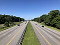
US 50 and US 301 in Queen Anne's County
_from_the_overpass_for_Nesbit_Road_in_Grasonville,_Queen_Anne%27s_County,_Maryland.jpg)
See also
 In Spanish: Condado de Queen Anne para niños
