Millington, Maryland facts for kids
Quick facts for kids
Millington, Maryland
|
|||
|---|---|---|---|
|
|||

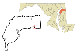
Location of Millington, Maryland
|
|||
| Country | United States | ||
| State | Maryland | ||
| Counties | Kent, Queen Anne's | ||
| Incorporated | 1890 | ||
| Area | |||
| • Total | 0.74 sq mi (1.92 km2) | ||
| • Land | 0.72 sq mi (1.85 km2) | ||
| • Water | 0.02 sq mi (0.06 km2) | ||
| Elevation | 20 ft (6 m) | ||
| Population
(2020)
|
|||
| • Total | 549 | ||
| • Density | 766.76/sq mi (295.98/km2) | ||
| Time zone | UTC-5 (Eastern (EST)) | ||
| • Summer (DST) | UTC-4 (EDT) | ||
| ZIP code |
21651
|
||
| Area code(s) | 410 443 | ||
| FIPS code | 24-52825 | ||
| GNIS feature ID | 0585893 | ||
Millington is a small town located in the state of Maryland, USA. It's unique because it sits across two counties: Kent and Queen Anne's. In 2020, about 549 people lived here. Millington is also important as it's the farthest point up the Chester River that boats can travel.
Contents
History of Millington
Millington became an official town in 1890. A historic place called the John Embert Farm was added to the National Register of Historic Places in 1980. This list helps protect important historical sites.
Geography and Location
Millington is found at specific map coordinates: 39.259355 degrees North and -75.838666 degrees West.
The United States Census Bureau says the town covers about 0.69 square miles (1.79 square kilometers). Most of this area is land, about 0.67 square miles (1.74 square kilometers). A small part, about 0.02 square miles (0.05 square kilometers), is water.
Transportation in Town
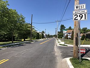
Getting around Millington mostly happens by road. Two main state highways serve the town. Maryland Route 291 goes through the town from east to west. Maryland Route 313 travels north and south from Millington.
Both of these roads connect to U.S. Route 301 to the northwest. This larger highway makes it easy to reach bigger cities like Philadelphia and Washington D.C. quickly.
Climate in Millington
The weather in Millington has hot and humid summers. Winters are generally mild, meaning not too cold. This type of weather is known as a humid subtropical climate. On climate maps, you might see this called "Cfa."
Population and People
| Historical population | |||
|---|---|---|---|
| Census | Pop. | %± | |
| 1860 | 306 | — | |
| 1870 | 420 | 37.3% | |
| 1880 | 444 | 5.7% | |
| 1890 | 485 | 9.2% | |
| 1900 | 406 | −16.3% | |
| 1910 | 399 | −1.7% | |
| 1920 | 368 | −7.8% | |
| 1930 | 371 | 0.8% | |
| 1940 | 307 | −17.3% | |
| 1950 | 356 | 16.0% | |
| 1960 | 408 | 14.6% | |
| 1970 | 474 | 16.2% | |
| 1980 | 546 | 15.2% | |
| 1990 | 409 | −25.1% | |
| 2000 | 416 | 1.7% | |
| 2010 | 642 | 54.3% | |
| 2020 | 549 | −14.5% | |
| U.S. Decennial Census | |||
2010 Census Details
In 2010, the town had 642 people living in 234 households. About 174 of these were families. The population density was about 958 people per square mile.
Most residents, about 72%, were White. About 13.9% were African American, and 3% were Asian. People of Hispanic or Latino background made up 13.9% of the population.
The average age in Millington was 36.2 years old. About 22.6% of the people were under 18. About 9% were 65 years old or older.
Education in Town
Students in Millington attend schools that are part of the Kent County Public Schools system.
- Kent County Middle School is located in Chestertown.
- Kent County High School is in an area near Butlertown with a Worton mailing address.
Millington Elementary School was closed by the school board in 2017. However, in 2019, there were talks about possibly reopening it.
See also
 In Spanish: Millington (Maryland) para niños
 | Selma Burke |
 | Pauline Powell Burns |
 | Frederick J. Brown |
 | Robert Blackburn |


