Kent County, Maryland facts for kids
Quick facts for kids
Kent County
|
|||
|---|---|---|---|

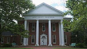
Kent County Courthouse in Chestertown
|
|||
|
|||

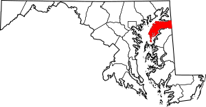
Location within the U.S. state of Maryland
|
|||
 Maryland's location within the U.S. |
|||
| Country | |||
| State | |||
| Founded | December 30, 1642 | ||
| Named for | Kent | ||
| Seat | Chestertown | ||
| Largest town | Chestertown | ||
| Area | |||
| • Total | 413 sq mi (1,070 km2) | ||
| • Land | 277 sq mi (720 km2) | ||
| • Water | 136 sq mi (350 km2) 33% | ||
| Population
(2020)
|
|||
| • Total | 19,198 | ||
| • Density | 46.48/sq mi (17.948/km2) | ||
| Time zone | UTC−5 (Eastern) | ||
| • Summer (DST) | UTC−4 (EDT) | ||
| Congressional district | 1st | ||
Kent County is a place in Maryland, a state in the United States. In 2020, about 19,198 people lived here. This makes it the county with the fewest people in Maryland. Its main town, called the county seat, is Chestertown.
Kent County was named after Kent, a county in England. It is located on the Eastern Shore of Maryland. It is also the oldest county in Maryland.
Contents
Kent County's History
In 1608, Captain John Smith explored and mapped parts of what is now Kent County. In 1642, leaders officially created the "Isle and County of Kent." This led to Kent County becoming a real place.
The first county seat was New Yarmouth in 1675. The main town then moved to Quaker Neck for a short time. Later, it moved to where Chestertown is today. Before the American Revolution, Chestertown was an important port. Ships came and went from here for several counties.
Kent County was the center of the U.S. population in the 1790 census. This means it was the average spot where all Americans lived.
In 1793, the county got its first newspaper, called Apollo, or Chestertown Spy. Other local papers, like the Chestertown Gazette, followed it.
Washington College
Washington College is in Kent County. It is the oldest college in Maryland. It was the first college created in the nation after the Declaration of Independence. William Smith founded it in 1782.
George Washington allowed the college to use his name. He also gave the college its largest gift of 50 guineas (an old type of money). Washington was part of the college's board for five years. Four U.S. Presidents have visited the college. They include George Washington, Harry S. Truman, Dwight D. Eisenhower, and Franklin D. Roosevelt. All of them received special degrees from the college.
War of 1812 in Kent County
The War of 1812 was the only war fought on Kent County's land. In 1813 and 1814, British soldiers attacked the Chesapeake Bay area. They looted and burned farms and towns.
People in Kent County and local soldiers bravely defended their homes. They showed great skill and courage. Important events included the burning of Georgetown, the saving of the Kitty Knight House, and the Battle of Caulk's Field.
Historic Churches
Kent County has several old and important churches.
- St. Paul's Episcopal Church: This is the oldest Episcopal Church in Maryland. People have used it for worship without stopping since it was built. The oldest part of the building was finished in 1711. It is about nine miles west of Chestertown.
- Christ Church (I.U.): This church was started in 1765. Colonel Philip Reed, a soldier from the Continental Army and the War of 1812, is buried here.
- Shrewsbury Church: This is thought to be the first building put up in the county, in 1693. John Cadwalader is buried in its churchyard. Thomas Paine wrote the words on his tombstone.
Geography of Kent County
Kent County covers about 413 square miles. About 277 square miles are land, and 136 square miles (33%) are water.
The highest point in Kent County is 102 feet above sea level. This spot is near Coleman's Corner.
Kent County has a long shoreline of 209 miles. This includes Eastern Neck Island. The Chesapeake Bay is to the west. The Sassafras River is to the north, and the Chester River is to the south. The eastern border with Delaware is part of the famous Mason–Dixon line.
Nearby Cities
- Baltimore, MD
- Washington D.C.
- Philadelphia, PA
- Wilmington, DE
Neighboring Counties
- Cecil County (north)
- New Castle County, Delaware (northeast)
- Queen Anne's County (south)
- Kent County, Delaware (southeast)
Protected Areas
Main Roads
 US 301
 MD 20
MD 20 MD 213
Population Information
Kent County's population has changed over many years. Here's how many people lived there during different census counts:
| Historical population | |||
|---|---|---|---|
| Census | Pop. | %± | |
| 1790 | 12,836 | — | |
| 1800 | 11,771 | −8.3% | |
| 1810 | 11,450 | −2.7% | |
| 1820 | 11,453 | 0.0% | |
| 1830 | 10,501 | −8.3% | |
| 1840 | 10,842 | 3.2% | |
| 1850 | 11,386 | 5.0% | |
| 1860 | 13,267 | 16.5% | |
| 1870 | 17,102 | 28.9% | |
| 1880 | 17,605 | 2.9% | |
| 1890 | 17,471 | −0.8% | |
| 1900 | 18,786 | 7.5% | |
| 1910 | 16,957 | −9.7% | |
| 1920 | 15,026 | −11.4% | |
| 1930 | 14,242 | −5.2% | |
| 1940 | 13,465 | −5.5% | |
| 1950 | 13,677 | 1.6% | |
| 1960 | 15,481 | 13.2% | |
| 1970 | 16,146 | 4.3% | |
| 1980 | 16,695 | 3.4% | |
| 1990 | 17,842 | 6.9% | |
| 2000 | 19,197 | 7.6% | |
| 2010 | 20,197 | 5.2% | |
| 2020 | 19,198 | −4.9% | |
| 2023 (est.) | 19,303 | −4.4% | |
| U.S. Decennial Census 1790–1960 1900–1990 1990–2000 2010–2018 |
|||
In 2010, there were 20,197 people living in Kent County. About 80% of the people were white, and 15% were black or African American. About 4.5% of the people were of Hispanic or Latino background. The average age of people in the county was 45.6 years old.
Schools and Colleges
Kent County Public Schools is the main school district for all of Kent County.
- Kent County High School
- Kent County Middle School
- Galena Elementary School
- Henry Highland Garnet Elementary School
- Rock Hall Elementary School
- Kent School
- Chestertown Christian Academy
- Echo Hill Outdoor School
- Radcliffe Creek School
- Washington College
- Chesapeake College (partly supported by the county, but located in Wye Mills)
Towns and Communities
Kent County has several towns and other communities.
Towns
- Betterton
- Chestertown (the county seat)
- Galena
- Millington (partly in Queen Anne's County)
- Rock Hall
Census-Designated Places
These are areas that the U.S. Census Bureau tracks for population data.
Other Communities
These are other small places in the county that are not official towns or census places.
Famous People from Kent County
- John Cadwalader (1742-1786): A Quaker military leader during the American Revolutionary War.
- James M. Cain (1892–1977): A well-known author, journalist, and professor.
- R. Clayton Mitchell Jr. (1936–2019): A political leader who served in the Maryland House of Delegates.
- John Needles (1786–1878): A Quaker who worked to end slavery and was a skilled furniture maker.
- Captain Lambert Wickes: A high-ranking officer in the Continental Navy during the Revolutionary War. He took Benjamin Franklin to France in 1777.
Interesting Facts About Kent County
- The local newspaper is the Kent County News.
- Kent County Public Schools were among the last in the country to fully integrate. This means students of all races could attend the same schools. A plan for integration was adopted in 1966, and schools were fully integrated by 1967. A new high school opened in 1971 for all students.
- Kent County, Maryland, is special because it borders a county with the same name in another state: Kent County, Delaware.
- In 1790, Kent County was the "center of population" for the United States. This spot is in a cornfield.
- Tolchester Beach Amusement Park opened in 1877. It was a very popular resort, with up to 20,000 visitors on summer weekends. It had games, a hotel, and a beach. The park closed in 1962.
- The Kent County Railroad Company started in 1856. It helped ship local products to markets. The railroad operated until the early 1970s.
- Chestertown Fountain Park has a beautiful fountain. It was bought in 1899 by the Ladies Improvement Society. On top of the fountain is a statue of Hebe, the Greek goddess of youth and beauty.
See also
 In Spanish: Condado de Kent (Maryland) para niños
 | Chris Smalls |
 | Fred Hampton |
 | Ralph Abernathy |


