Betterton, Maryland facts for kids
Quick facts for kids
Betterton, Maryland
|
|||
|---|---|---|---|
|
|||

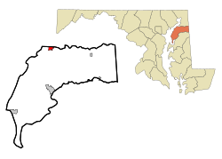
Location of Betterton, Maryland
|
|||
| Country | |||
| State | |||
| County | |||
| Incorporated | 1906 | ||
| Government | |||
| • Type | Mayor-Council | ||
| Area | |||
| • Total | 1.00 sq mi (2.58 km2) | ||
| • Land | 0.99 sq mi (2.56 km2) | ||
| • Water | 0.01 sq mi (0.02 km2) | ||
| Elevation | 72 ft (22 m) | ||
| Population
(2020)
|
|||
| • Total | 286 | ||
| • Density | 288.89/sq mi (111.54/km2) | ||
| Time zone | UTC-5 (Eastern (EST)) | ||
| • Summer (DST) | UTC-4 (EDT) | ||
| ZIP code |
21610
|
||
| Area code(s) | 410 | ||
| FIPS code | 24-07200 | ||
| GNIS feature ID | 0583196 | ||
Betterton is a small and charming town located in Kent County, Maryland, in the United States. It's known for its beautiful location on the water. In 2020, about 286 people lived here.
Contents
Exploring Betterton's Location
Betterton is found right where the Sassafras River meets the upper part of the Chesapeake Bay. This area is part of the Eastern Shore and the Delmarva Peninsula. It's a lovely spot in the eastern United States.
The town covers about 2.58 square kilometers (1 square mile). Most of this area is land, with a small part being water.
Discovering Betterton's History
Betterton has a long and interesting history that goes back to the 1600s. The area was first called Fishall in 1664. Later, in 1715, it became known as Crews Landing. For many years, it was a small village where people fished and shipped farm goods by water.
In 1851, a man named Richard Townsend Turner renamed the town "Betterton." He named it after his wife's family. Piers were built, like the Turner pier, which helped ships and visitors come to town. Soon, people started renting out rooms to travelers. Large hotels like the Rigbie Hotel and the Belmont Hotel were built. Many other places offered lodging too, like the Betterton, Chesapeake, and Southern hotels.
The Steamboat Era
Steamboats brought many visitors to Betterton from cities like Baltimore and Philadelphia. Companies like the Old Bay Line and the Ericsson Line offered fun trips. The Ericsson Line was named after John Ericsson, who invented the "screw propeller." This invention helped steamboats travel faster. It also allowed them to fit through the Chesapeake and Delaware Canal, which was narrow back then.
Betterton became a popular stop for boats using the canal. This led to a big boom for the town. At one point, 11 steamboats arrived daily! The years between 1918 and 1930 were especially busy. Many restaurants, dance halls, bowling alleys, and arcades opened. Betterton became a famous resort town by the bay.
However, after the Chesapeake Bay Bridge was built in the early 1950s, more people started traveling by car. They could easily drive to other beach towns like Ocean City, Maryland and Rehoboth Beach, Delaware. This caused Betterton's popularity as a steamboat resort to decline.
Betterton Historic District
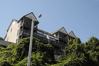
The Betterton Historic District is a special area in town. It has many old wooden buildings built in the Victorian style. These buildings were once homes, hotels, and cottages for steamboat passengers in the late 1800s and early 1900s.
You can see many of the original hotels, boarding homes, churches, and summer cottages from Betterton's "golden age." This district was added to the National Register of Historic Places in 1984. This means it's recognized as an important historical site.
Getting Around Betterton
The main way to travel to and from Betterton is by road. Maryland Route 292 is the only state highway that serves the town. It ends at the northern part of Betterton.
Fun at Betterton Beach
Betterton Beach is a great place to visit! It's located at the end of Main Street. The beach has about 91 meters (300 feet) of space for swimming. The water here is not very salty, so you usually won't find many sea nettles (jellyfish).
The beach offers public restrooms (open during certain seasons), a boardwalk, and a fishing jetty. There's also a public landing for boats and plenty of parking. A picnic area is nearby, perfect for a meal outdoors.
Betterton's Population Over Time
| Historical population | |||
|---|---|---|---|
| Census | Pop. | %± | |
| 1910 | 308 | — | |
| 1920 | 327 | 6.2% | |
| 1930 | 296 | −9.5% | |
| 1940 | 221 | −25.3% | |
| 1950 | 314 | 42.1% | |
| 1960 | 328 | 4.5% | |
| 1970 | 327 | −0.3% | |
| 1980 | 356 | 8.9% | |
| 1990 | 360 | 1.1% | |
| 2000 | 376 | 4.4% | |
| 2010 | 345 | −8.2% | |
| 2020 | 286 | −17.1% | |
| U.S. Decennial Census | |||
Who Lives in Betterton?
According to the 2010 census, 345 people lived in Betterton. There were 156 households, with 88 of them being families. Most residents (92.5%) were White. About 2.9% were African American, and smaller percentages were Native American, Asian, or from other backgrounds. About 2.9% of the population was Hispanic or Latino.
The average age of people in Betterton was about 46.9 years old. About 18.6% of residents were under 18. Many people were between 45 and 64 years old (36.7%).
Schools in Betterton
Students in Betterton attend schools in the Kent County Public Schools system. Older students go to Kent County Middle School in Chestertown. They also attend Kent County High School, which is located in an unincorporated area near Butlertown.
The local elementary school for Betterton used to be Worton Elementary School. However, the school board decided to close Worton Elementary in 2017.
See also
 In Spanish: Betterton (Maryland) para niños
 | Roy Wilkins |
 | John Lewis |
 | Linda Carol Brown |


