
Sassafras River facts for kids
Quick facts for kids Sassafras River |
|
|---|---|

A view of the Sassafras on a windy day with the northern shore in the background
|
|

The Sassafras River and its watershed is highlighted in yellow on this map of the rivers of the Eastern Shore of Maryland
|
|
| Other name(s) | Tributary to Chesapeake Bay |
| Country | United States |
| State | Maryland Delaware |
| Counties | Cecil (MD) Kent (MD) New Castle (DE) |
| Physical characteristics | |
| Main source | divide between Sassafras River and Blackbird Creek about 0.5 miles ENE of Vandyke, Delaware 80 ft (24 m) 39°21′54″N 075°43′59″W / 39.36500°N 75.73306°W |
| River mouth | Chesapeake Bay Betterton, Maryland 0 ft (0 m) 39°23′14″N 076°03′13″W / 39.38722°N 76.05361°W |
| Length | 18.98 mi (30.55 km) |
| Basin features | |
| Progression | west |
| River system | Chesapeake Bay |
| Basin size | 91.88 square miles (238.0 km2) |
| Tributaries |
|
The Sassafras River is a cool river that flows into the famous Chesapeake Bay. It's located on the Delmarva Peninsula in the United States. This river is about 22 miles (35 km) long. It starts in western New Castle County, Delaware. The river then forms the border between Cecil County, Maryland, to the north and Kent County, Maryland, to the south.
The Sassafras River begins southwest of Middletown, Delaware. It ends where it meets the Chesapeake Bay. This wide mouth is found between Howell Point near Betterton, Maryland, and Grove Point on Grove Neck. The river is south of the Elk River and north of the Chester River.
The entire Sassafras River is within a flat area called the coastal plain. The total area that drains into the river, including the water itself, is about 97 square miles (250 km2). Out of this, 83 square miles (210 km2) is land. This means about 14% of its watershed area is water.
Many smaller creeks flow into the Sassafras River. On the northern side, you'll find Money Creek, Cox Creek, Foreman Creek, Back Creek, McGill Creek, Dowdel Creek, Hall Creek, and Duffy Creek. On the southern side, there are Lloyd Creek, Turner's Creek, Freeman Creek, Woodland Creek, Dyer Creek, Mill Creek, Swantown Creek, Jacobs Creek, and Herring Branch.
Back in 1612, when John Smith mapped this area, he called it the Tockwogh River.
Exploring Sassafras River Parks
You can find several parks along the southern side of the Sassafras River. These parks are managed by different groups, including national, state, and county governments. They offer a mix of things to do, from historical sites and fun recreation areas to places that protect nature and wildlife.
One special area on the southern shore used to be a large piece of land with farms and a pond. It was owned by Liz Maytag and Mike Revuke. After they passed away, this land was given to become a wildlife sanctuary. This means it's now a safe place for animals and plants to live. Liz and Mike also owned The Granary, which is a marina and restaurant in Georgetown.
Boating on the Sassafras River

The Sassafras River is a popular spot for boats! It has many boats and four big marinas. All these marinas are located close to Georgetown, Maryland.
The main path for boats, called the channel, is marked by buoys. It's at least 10 feet deep until you reach the bridge for Maryland Route 213. The deepest part of the Sassafras River is right in the middle, east of buoy 5. Here, the water can be more than 50 feet (15 m) deep!
If you go further upriver, the water gets much shallower. It becomes too shallow for even small motorboats. In these areas, only kayaks or canoes can easily travel.
Even with the shallow parts upriver, the lower part of the Sassafras River is very busy with boats on weekends. You'll see all kinds of boats, like small bow-riders, cruisers, and many different sailboats. Sometimes, you might even spot a huge motor yacht. Most of these boats come from the marinas. However, some also come from private docks along the river, especially on the southern side.
There are also several beaches along the river. Boaters can anchor their boats there and go for a swim. If you like water sports, you can ski or tube in one of the river's many creeks and coves. These spots are great because they help avoid big waves from other boats.
Most of the docks along the river are fixed, meaning they don't float. This is because of the large waves, called wakes, which can be up to 2 feet (0.61 m) high on a busy day. Marinas are somewhat protected because they have "no wake" zones. In these zones, boats must go slowly, no faster than 5 mph. One such zone is at Gregg Neck Boat Yard, stretching from buoy 12 to just east of the 213 drawbridge. Some boat owners with private docks have also installed boat lifts. These lifts raise their boats out of the water, keeping them safe from the wakes.
Images for kids
-
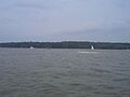
A view of the Sassafras on a windy day with the northern shore in the background
-
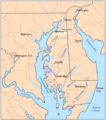
The Sassafras River and its watershed is highlighted in yellow on this map of the rivers of the Eastern Shore of Maryland
-
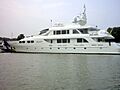
A large motoryacht docked at Skipjack Marina
