Cecil County, Maryland facts for kids
Quick facts for kids
Cecil County
|
|||
|---|---|---|---|

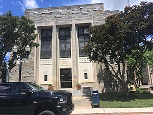
Cecil County Circuit Courthouse in Elkton
|
|||
|
|||

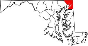
Location within the U.S. state of Maryland
|
|||
 Maryland's location within the U.S. |
|||
| Country | |||
| State | |||
| Founded | June 6, 1674 | ||
| Named for | Cecil Calvert | ||
| Seat | Elkton | ||
| Largest town | Elkton | ||
| Area | |||
| • Total | 418 sq mi (1,080 km2) | ||
| • Land | 346 sq mi (900 km2) | ||
| • Water | 72 sq mi (190 km2) 17% | ||
| Population
(2020)
|
|||
| • Total | 103,725 | ||
| • Density | 248.15/sq mi (95.81/km2) | ||
| Time zone | UTC−5 (Eastern) | ||
| • Summer (DST) | UTC−4 (EDT) | ||
| Congressional district | 1st | ||
Cecil County is a county in the state of Maryland, USA. It's located in the very northeast corner of Maryland. This county shares borders with both Pennsylvania and Delaware.
In 2020, about 103,725 people lived here. The main town and county seat is Elkton. Cecil County is part of Maryland's "Eastern Shore" region.
The county was named after Cecil Calvert, 2nd Baron Baltimore. He was the first leader of the Maryland colony. Because the eastern part of Cecil County is closer to Philadelphia than Baltimore, it's considered part of the larger Philadelphia area.
Contents
History of Cecil County
The area that is now Cecil County was an important place for trading long ago. This was even before it officially became a county in 1674. Native American groups like the Piscataway, Susquehannock, and Lenape traded here.
Captain John Smith visited this area in 1608. Later, a trader named William Claiborne set up a trading post. This was at what is now Garrett Island, near the Susquehanna River.
A man named Augustine Herman helped create Cecil County. He drew maps in 1674 and received a lot of land for his work. One of his lands became Bohemia Manor.
Early Times and the American Revolution
Before the American Revolution, Cecil County was a busy shipping center. It sent farm products, animal skins, and tobacco to other colonies and countries.
Some of Maryland's oldest churches are in Cecil County. St. Francis Xavier Church (Warwick, Maryland) started as a mission in 1704. St. Mary Anne's Episcopal Church was built in 1742 and is still used today.
West Nottingham Academy was founded in 1744. Two of its students, Benjamin Rush and Richard Stockton, later signed the Declaration of Independence.
The Principio Furnace, an iron factory, started in 1719. It became important for making and selling iron. During the American Revolution, both British and American soldiers passed through Cecil County. However, no big battles happened here.
The War of 1812 and Transportation Changes
The War of 1812 caused a lot of damage in Cecil County. British ships blocked the Chesapeake Bay. They destroyed a trading post called Frenchtown. They also destroyed the Principio Iron Works.
After the war, transportation changed a lot. The Susquehanna Canal opened in 1812. This helped the town of Port Deposit grow.
Steamboats became popular for travel on the bay. They carried people between Baltimore and Elkton. From Elkton, travelers could take stage coaches to cities like Philadelphia.
A very important project was the Chesapeake and Delaware Canal. It was built between 1824 and 1829. This 14-mile canal connected the Elk River (and the Chesapeake Bay) to the Delaware River. It became one of the busiest canals in the country. Today, the U.S. Army Corps of Engineers still runs it. Chesapeake City, Maryland has a museum about the canal.
Railroads also became very important. The New Castle and Frenchtown Railroad started in 1831. Soon, railroads crossed Cecil County. While they helped travel, they also made the county's small ports less important for trade.
The Civil War and Beyond
During the American Civil War, Perryville, Maryland was a key spot for Union soldiers. No battles happened in Cecil County itself. However, people in the county had very different feelings about the war.
Slavery had been declining in the county. The Underground Railroad also passed through Cecil County. Frederick Douglass, a famous abolitionist, traveled through here on his way to freedom in 1838.
After the Civil War, Perryville became a railroad town again. Later, it also got business from travelers on the new interstate highways. Cecil County was once one of the wealthiest in Maryland. Today, it works hard to attract new businesses and tourists.
Cecil County has many places listed on the National Register of Historic Places. These are important historical sites.
Geography
Cecil County is in the northeast corner of Maryland. It covers about 418 square miles. About 346 square miles are land, and 72 square miles (17%) are water.
The county's northern and eastern borders are the Mason–Dixon line. This line separates Maryland from Pennsylvania and Delaware. To the west, you'll find the Susquehanna River and parts of the Chesapeake Bay. The Sassafras River and Kent County, Maryland form the southern border. Cecil County is part of the Delmarva Peninsula and Maryland's "Eastern Shore."
Landscape and Features
Cecil County has two main types of land. North of Route 40, there are rolling hills, part of the Piedmont Plateau. South of Route 40, the land is flatter, part of the Atlantic Coastal Plain. The highest hills are in the northwest, reaching about 534 feet (163 meters). The lowest point is sea level along the Chesapeake Bay.
Most of Cecil County is rural, meaning it has a lot of open land and farms. However, there are more buildings and people around Elkton and along Route 40.
The county is cut from east to west by the Chesapeake and Delaware Canal. This canal connects the Delaware River to the Chesapeake Bay through the Elk River. Large ships can pass under the Chesapeake City Bridge in Chesapeake City, Maryland.
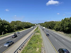
Interstate 95 also crosses Cecil County from east to west. This highway is a major route for traffic. It connects the Baltimore-Washington area to the Philadelphia and New York regions.
Neighboring Areas
Cecil County is next to these other counties:
- Chester County, Pennsylvania (north)
- Lancaster County, Pennsylvania (northwest)
- New Castle County, Delaware (east)
- Harford County (west)
- Kent County (south)
Main Roads
Here are some of the most important roads in Cecil County:
Transportation
Major Roads and Highways
Cecil County has several important roads and highways. These roads help people travel within the county and to other states.
 I-95
I-95 US 1
US 1 US 40
US 40 US 222
 US 301
 MD 7
MD 7 MD 213
 MD 222
 MD 272
 MD 273
 MD 274
 MD 275
 MD 276
 MD 277
 MD 279
 MD 282
 MD 284
 MD 285
 MD 286
 MD 310
 MD 316
 MD 545
 MD 896
Public Transportation
Cecil Transit is the public bus service in Cecil County. It offers bus routes and on-demand rides.
The MARC commuter train service ends in Perryville, Maryland. This train connects to Baltimore and Washington, D.C.. There are ideas to extend this train line further north into Delaware.
Population
Cecil County has grown quite a bit over the years. Here's a look at how the population has changed:
| Historical population | |||
|---|---|---|---|
| Census | Pop. | %± | |
| 1790 | 13,625 | — | |
| 1800 | 9,018 | −33.8% | |
| 1810 | 13,066 | 44.9% | |
| 1820 | 16,048 | 22.8% | |
| 1830 | 15,432 | −3.8% | |
| 1840 | 17,232 | 11.7% | |
| 1850 | 18,939 | 9.9% | |
| 1860 | 23,862 | 26.0% | |
| 1870 | 25,874 | 8.4% | |
| 1880 | 27,108 | 4.8% | |
| 1890 | 25,851 | −4.6% | |
| 1900 | 24,662 | −4.6% | |
| 1910 | 23,759 | −3.7% | |
| 1920 | 23,612 | −0.6% | |
| 1930 | 25,827 | 9.4% | |
| 1940 | 26,407 | 2.2% | |
| 1950 | 33,356 | 26.3% | |
| 1960 | 48,408 | 45.1% | |
| 1970 | 53,291 | 10.1% | |
| 1980 | 60,430 | 13.4% | |
| 1990 | 71,347 | 18.1% | |
| 2000 | 85,951 | 20.5% | |
| 2010 | 101,108 | 17.6% | |
| 2020 | 103,725 | 2.6% | |
| 2023 (est.) | 105,672 | 4.5% | |
| U.S. Decennial Census 1790-1960 1900-1990 1990-2000 2010 2020 |
|||
Who Lives in Cecil County?
In 2020, there were 103,725 people living in Cecil County.
- About 80.5% of people were White (not Hispanic).
- About 7.2% were Black or African American (not Hispanic).
- About 1.2% were Asian (not Hispanic).
- About 5.2% were of mixed race (not Hispanic).
- About 5.25% of the population was Hispanic or Latino (of any race).
In 2010, there were 101,108 people. The average age was 38.9 years old. Many households had children under 18. The average income for a household was about $64,886.
Education
Cecil County has a good education system. Cecil County Public Schools runs all the public schools.
- There are 17 elementary schools.
- There are six middle schools.
- There are five high schools.
- The Cecil County School of Technology teaches skills for different jobs.
Cecil College is a local college with four campuses in the county.
Libraries
The Cecil County Public Library has 7 branches. They also offer many programs and services throughout the county.
Towns and Communities
Cecil County has several towns and many smaller communities.
- Towns
- Cecilton
- Charlestown
- Chesapeake City
- Elkton (county seat)
- North East
- Perryville
- Port Deposit
- Rising Sun
- Unincorporated communities
These are smaller communities that are not officially towns:
- Appleton
- Bay View
- Blue Ball Village
- Calvert
- Carpenter Point
- Cherry Hill
- Childs
- Colora
- Conowingo
- Crystal Beach
- Earleville
- Elk Mills
- Elk Neck
- Fair Hill
- Fredericktown
- Frenchtown
- Hack's Point
- Harrisville
- Hopewell Manor
- Liberty Grove
- Oakwood
- Perry Point
- Providence
- Red Point
- St. Augustine
- Warwick
- Westminister
- White Crystal Beach
- White Hall
- Zion
Famous People from Cecil County
- John Smith (1580–1631), the first European to explore this area.
- William Paca (1740–1799), a leader during the American Revolution. He signed the Declaration of Independence and was later Governor of Maryland.
- George Read (1733–1798), a judge and Revolutionary War leader. He was a U.S. Senator.
- Robert Alexander, a delegate to the Continental Congress.
- John Andrews (1746–1813), a professor and clergyman.
- Robert Somers Brookings, who started the Brookings Institution, a famous research group.
- David Davis, a Supreme Court Justice.
- Levi Davis, an Illinois State Auditor and lawyer.
See also
 In Spanish: Condado de Cecil para niños
 | DeHart Hubbard |
 | Wilma Rudolph |
 | Jesse Owens |
 | Jackie Joyner-Kersee |
 | Major Taylor |


