Chester County, Pennsylvania facts for kids
Quick facts for kids
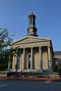
Chester County
|
|||
|---|---|---|---|
|
|||
|
|||
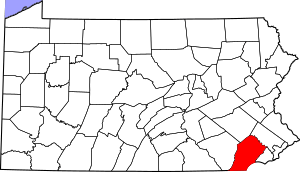
Location within the U.S. state of Pennsylvania
|
|||
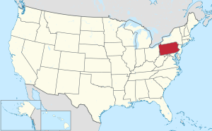 Pennsylvania's location within the U.S. |
|||
| Country | |||
| State | |||
| Founded | August 24, 1682 | ||
| Named for | Chester, England | ||
| Seat | West Chester | ||
| Largest borough | West Chester | ||
| Area | |||
| • Total | 759 sq mi (1,970 km2) | ||
| • Land | 751 sq mi (1,950 km2) | ||
| • Water | 8.7 sq mi (23 km2) 1.1%% | ||
| Population
(2020)
|
|||
| • Total | 534,413 | ||
| • Estimate
(2023)
|
546,638 |
||
| • Density | 712.0/sq mi (274.9/km2) | ||
| Time zone | UTC−5 (Eastern) | ||
| • Summer (DST) | UTC−4 (EDT) | ||
| Congressional districts | 5th, 6th | ||
|
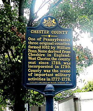
Pennsylvania Historical Marker
|
|||
| Designated: | October 26, 1982 | ||
Chester County, also known as Chesco, is a county in the state of Pennsylvania. It is located in the southeastern part of the state, near the Delaware Valley region. In 2020, about 545,823 people lived here. This was a 7.1% increase from 2010.
The main town where the county government is located is West Chester. The biggest town in the county is Tredyffrin Township. Other large towns include West Chester and Phoenixville. Coatesville is the only place in the county that is officially called a city.
Chester County was one of the first three counties created by William Penn in 1682. It was named after Chester, a city in England. The county is part of a larger area that includes Philadelphia, Camden, and Wilmington. Many towns in eastern Chester County are part of the "Philadelphia Main Line" area, which are western suburbs of Philadelphia.
In 2020, Chester County had the highest average household income in Pennsylvania. It was also the 35th highest in the entire United States.
Contents
History
Chester County was one of the first three counties in Pennsylvania. It was created by William Penn on August 24, 1682, when Pennsylvania was still a colony.
Back then, Chester County was much larger. It stretched from Philadelphia County in the north to the Susquehanna River in the west. The Delaware River was its eastern border, and Delaware and Maryland were to the south. Many early settlers in the eastern part of the county were from Wales, which is why you can still find many Welsh place names there today.
Over time, parts of Chester County were used to create new counties. Lancaster County was formed from Chester County in 1729. Later, in 1752, Berks County was also created from parts of Chester, Lancaster, and Philadelphia counties.
The original county seat (where the government was) was the City of Chester. This city was important for building ships. But as more people moved to the western part of the county, it became too far for them to travel. So, in 1788, the county seat was moved to a more central village called Turk's Head. This village was then renamed West Chester. Because of this move, the eastern part of the county decided to form its own county, Delaware County, in 1789. The City of Chester became the county seat for Delaware County.
Chester County's location between Philadelphia and the Susquehanna River has been very important to its history. The first main road to the west, which led to Lancaster County, went right through the middle of Chester County. This road later became U.S. Route 30. Early railroads also followed this path. This easy transportation helped industries grow along the rail lines. It also made it easier for people to live in the county and travel to jobs in nearby cities. This is how the suburbs started to grow. Even today, the most developed areas of the county are along these major transportation routes.
During the American Revolutionary War, several important battles happened in Chester County. The Battle of Brandywine was fought in the southeastern part of the county. The Battle of the Clouds and the Battle of Paoli took place in the northeastern part. George Washington and his army also camped at Valley Forge in this area.
Geography
Chester County covers about 759 square miles. Most of this is land (751 square miles), and a small part (8.7 square miles) is water. The land here has rolling hills and valleys. It is part of a region called the Piedmont.
Several creeks and rivers flow through Chester County, including the Octoraro, Brandywine, and Chester creeks, and the Schuylkill River. The soil is very fertile, which made it a major farming area for a long time. Because it's close to Philadelphia, Chester County has seen a lot of growth and new buildings in the last 50 years as more people moved to the suburbs.
Even with all the new development, farming is still a big part of Chester County's economy. There are also many horse farms. Growing mushrooms is a special type of farming in the southern part of the county.
Chester County is unique because it is the only county in Pennsylvania that borders both Delaware and Maryland.
Adjacent counties
- Berks County (north)
- Montgomery County (northeast)
- Delaware County (east)
- New Castle County, Delaware (southeast)
- Cecil County, Maryland (south)
- Lancaster County (west)
National protected area
State protected areas
Major roads and highways

 I-76 / Penna Turnpike
 US 1
US 1 US 30
US 30
 US 30 Bus.
 US 202
 US 322


 US 322 Bus.
 US 422
 PA 3
PA 3 PA 10
PA 10 PA 23
PA 23 PA 29
PA 29 PA 41
PA 41 PA 52
PA 52 PA 82
PA 82 PA 100
 PA 113
 PA 162
 PA 252
 PA 272
 PA 282
 PA 340
 PA 345
 PA 352
 PA 372
 PA 401
 PA 472
 PA 724
 PA 796
 PA 841
 PA 842
 PA 896
 PA 926
Economy and environment
Chester County is home to many businesses. For example, the Lanchester Landfill, which is on the border of Chester and Lancaster Counties, collects methane gas. This gas is then sold to local businesses as a clean energy source. This helps reduce pollution and offers an alternative to other energy sources.
Many companies have their main offices or a big presence in Chester County. Some of these include Bentley Systems, QVC (a shopping channel), The Vanguard Group (a big investment company), and Victory Brewing Company (a brewery).
Demographics
| Historical population | |||
|---|---|---|---|
| Census | Pop. | %± | |
| 1790 | 27,829 | — | |
| 1800 | 32,093 | 15.3% | |
| 1810 | 39,596 | 23.4% | |
| 1820 | 44,451 | 12.3% | |
| 1830 | 50,910 | 14.5% | |
| 1840 | 57,515 | 13.0% | |
| 1850 | 66,438 | 15.5% | |
| 1860 | 74,578 | 12.3% | |
| 1870 | 77,805 | 4.3% | |
| 1880 | 83,481 | 7.3% | |
| 1890 | 89,377 | 7.1% | |
| 1900 | 95,695 | 7.1% | |
| 1910 | 109,213 | 14.1% | |
| 1920 | 115,120 | 5.4% | |
| 1930 | 126,629 | 10.0% | |
| 1940 | 135,626 | 7.1% | |
| 1950 | 159,141 | 17.3% | |
| 1960 | 210,608 | 32.3% | |
| 1970 | 278,311 | 32.1% | |
| 1980 | 316,660 | 13.8% | |
| 1990 | 376,396 | 18.9% | |
| 2000 | 433,501 | 15.2% | |
| 2010 | 498,886 | 15.1% | |
| 2020 | 534,413 | 7.1% | |
| U.S. Decennial Census 1790–1960 1900–1990 1990–2000 2010–2019 |
|||
In 2010, most people in Chester County (82.1%) were White. About 6.1% were Black or African American, and 3.9% were Asian. About 6.5% of the population was Hispanic or Latino.
The county's population has grown a lot over the years. In 2000, there were 433,501 people. By 2010, it grew to 498,886. In 2020, the population was 534,413.
The area was first home to the Lenni Lenape people. Later, settlers from England, Scotland, and Wales came. In the late 1800s and early 1900s, many immigrants from Germany, Ireland, Eastern Europe, and Italy moved to industrial areas like Coatesville. People from the American South, both Black and White, also moved north for jobs. More recently, Hispanic immigrants, including Puerto Ricans and Mexicans, have moved to the county.
Chester County used to be mostly rural (farmland). But now, it's one of the fastest-growing counties in the Delaware Valley and the northeastern United States.
Religion
Because of its early history, Chester County has many old Quaker buildings, called meeting houses. Some of these include Birmingham, Bradford, and Old Kennett meeting houses.
Other historic religious buildings include St. Malachi Church, which is the oldest active Catholic mission church in southeastern Pennsylvania. There are also several old Episcopal churches like St. Mary's and St. Peter's. The First Presbyterian Church of West Chester and Coventryville United Methodist Church are also in the county. The Beth Israel Congregation of Chester County is a Conservative synagogue in Coatesville, a town that saw many Eastern European immigrants in the 1900s.
2020 census
| Race | Num. | Perc. |
|---|---|---|
| White (NH) | 405,476 | 75.87% |
| Black or African American (NH) | 28,391 | 5.31% |
| Native American (NH) | 532 | 0.1% |
| Asian (NH) | 35,143 | 6.62% |
| Pacific Islander (NH) | 119 | 0.02% |
| Other/Mixed (NH) | 21,210 | 4% |
| Hispanic or Latino | 43,542 | 8.15% |
Education
Colleges and universities
- Cheyney University of Pennsylvania (partially in Delaware County)
- Delaware County Community College (locations in Downingtown and West Grove)
- Immaculata University
- Lansdale School of Business (location in Phoenixville)
- Lincoln University
- Penn State Great Valley
- University of Valley Forge
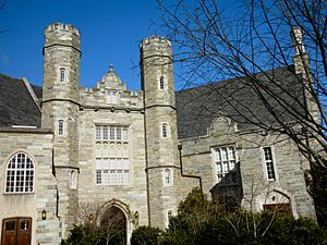
- West Chester University
Public school districts
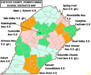
School districts include:
- Avon Grove School District
- Coatesville Area School District
- Downingtown Area School District
- Great Valley School District
- Kennett Consolidated School District
- Octorara Area School District
- Owen J. Roberts School District
- Oxford Area School District
- Phoenixville Area School District
- Spring-Ford Area School District
- Tredyffrin/Easttown School District
- Twin Valley School District
- Unionville-Chadds Ford School District
- West Chester Area School District
Charter schools
- Achievement House Charter School grades 9–12, Exton
- Avon Grove Charter School grades K-12, West Grove
- Chester County Family Academy Charter School grades K-2, West Chester
- Collegium Charter School grades K-12, Exton
- Pennsylvania Leadership Charter School K-12, West Chester
- Renaissance Academy Charter School grades K-12, Phoenixville
- Sankofa Academy Charter School grades 5–8, West Chester
- 21st Century Cyber Charter School grades 6–12. Downingtown.
Independent schools
- Bishop Shanahan High School (Archdiocese of Philadelphia)
- Center for Arts and Technology (Administered by Chester County Intermediate Unit)
- Church Farm School (now called CFS the School at Church Farm)
- Delaware Valley Friends School
- Devon Preparatory School
- Fairville Friends School (Chadds Ford, Pennsylvania)
- Goshen Friends School (West Chester, Pennsylvania)
- Kimberton Waldorf School (Kimberton, Pennsylvania)
- London Grove Friends Kindergarten (Kennett Square, Pennsylvania)
- Malvern Preparatory School
- The Concept School - 6th through 12th Grade
- Upattinas School and Resource Center (Glenmoore, Pennsylvania)
- Upland Country Day School (UCDS) - Pre-K through 9th Grade
- Villa Maria Academy (Malvern, Pennsylvania)
- Villa Maria Academy Lower School (Immaculata, Pennsylvania)
- West-Mont Christian Academy
- West Chester Friends School
- West Fallowfield Christian School
- Westtown School
- Windsor Christian Academy - K through 6th Grade
- Windsor Christian Preschool
- Regina Luminis Academy
Libraries
The Chester County Library System helps people find books and information. It was started in 1965 and has a main library in Exton and sixteen other libraries.
Communities
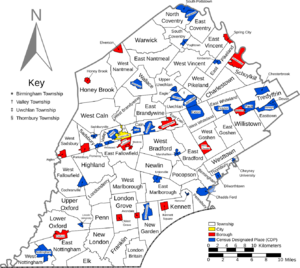
In Pennsylvania, there are different types of towns: cities, boroughs, and townships. The names used by the post office for mailing addresses often don't match the official town names, except for cities and boroughs. Here are the different types of communities in Chester County:
City
Boroughs
Townships
- Birmingham
- Caln
- Charlestown
- East Bradford
- East Brandywine
- East Caln
- East Coventry
- East Fallowfield
- East Goshen
- East Marlborough
- East Nantmeal
- East Nottingham
- East Pikeland
- East Vincent
- East Whiteland
- Easttown
- Elk
- Franklin
- Highland
- Honey Brook
- Kennett
- London Britain
- London Grove
- Londonderry
- Lower Oxford
- New Garden
- New London
- Newlin
- North Coventry
- Penn
- Pennsbury
- Pocopson
- Sadsbury
- Schuylkill
- South Coventry
- Thornbury
- Tredyffrin
- Upper Oxford
- Upper Uwchlan
- Uwchlan
- Valley
- Wallace
- Warwick
- West Bradford
- West Brandywine
- West Caln
- West Fallowfield
- West Goshen
- West Marlborough
- West Nantmeal
- West Nottingham
- West Pikeland
- West Sadsbury
- West Vincent
- West Whiteland
- Westtown
- Willistown
Census-designated places
These are communities that the U.S. Census Bureau uses for collecting data, but they are not official towns under Pennsylvania law.
- Berwyn
- Caln
- Cambridge (mostly in Lancaster County)
- Chadds Ford (partly in Delaware County)
- Chesterbrook
- Cheyney University (partly in Delaware County)
- Cochranville
- Devon
- Dilworthtown (partly in Delaware County)
- Eagle
- Eagleview
- Exton
- Frazer
- Glenmoore
- Hamorton
- Hayti
- Kenilworth
- Kimberton
- Lincoln University
- Lionville
- Marshallton
- Nottingham
- Paoli
- Pomeroy
- Pughtown
- Sadsburyville
- South Pottstown
- Thorndale
- Toughkenamon
- Unionville
- Westwood
Other unincorporated communities
- Birchrunville
- Black Horse
- Brandamore
- Bucktown
- Byers Station
- Cedarville
- Chatham
- Chester Springs
- Chesterville
- Compass
- Coventryville
- Cromby
- Darlington Corners
- Daylesford
- Devault
- Doe Run
- Dorlan
- Embreeville
- Ercildoun
- Faggs Manor
- Glenloch
- Goshenville
- Hallman
- Harmonyville
- Hayesville
- Hephzibah
- Hickory Hill
- Hiestand
- Homeville
- Hopewell
- Humphreyville
- Icedale
- Ironsides
- Isabella
- Jennersville
- Kaolin
- Kelton
- Kemblesville
- Knauertown
- Landenberg
- Lenape
- Lewisville
- London Grove
- Longwood
- Lower Hopewell
- Ludwigs Corner
- Lyndell
- Mendenhall
- Milford Mills
- Mortonville
- Morstein
- Nantmeal Village
- Northbrook
- Parker Ford
- Pocopson
- Russellville
- Saint Peters
- Siousca
- Springdell
- Steelville
- Strafford
- Strickersville
- Sugartown
- Suplee
- Valley Forge
- Wagontown
- Warwick
- West Goshen
- Whitford
- Willowdale
- Yellow Springs
Historic community
- Barnestown
Population ranking
This table shows the population of the biggest towns and areas in Chester County, based on the 2020 census.
† county seat
| Rank | City/Town/etc. | Municipal type | Population (2020 Census) |
|---|---|---|---|
| 1 | Tredyffrin | Township | 31,927 |
| 2 | West Goshen | Township | 23,040 |
| 3 | West Whiteland | Township | 19,632 |
| 4 | Uwchlan | Township | 19,161 |
| 5 | West Chester † | Borough | 18,671 |
| 6 | Phoenixville | Borough | 18,602 |
| 7 | East Goshen | Township | 18,410 |
| 8 | Caln | Township | 14,432 |
| 9 | West Bradford | Township | 14,316 |
| 10 | East Whiteland | Township | 13,917 |
| 11 | Coatesville | City | 13,350 |
| 12 | Upper Uwchlan | Township | 12,275 |
| 13 | New Garden | Township | 11,363 |
| 14 | Willistown | Township | 11,273 |
| 15 | Westtown | Township | 11,154 |
| 16 | Easttown | Township | 10,984 |
| 17 | East Bradford | Township | 10,339 |
| 18 | East Brandywine | Township | 9,738 |
| 19 | East Nottingham | Township | 8,982 |
| 20 | West Caln | Township | 8,910 |
| 21 | London Grove | Township | 8,797 |
| 22 | Schuylkill | Township | 8,780 |
| 23 | North Coventry | Township | 8,441 |
| 24 | Kennett | Township | 8,289 |
| 25 | Honey Brook | Township | 8,274 |
| 26 | East Pikeland | Township | 8,260 |
| 27 | Valley | Township | 7,985 |
| 28 | Downingtown | Borough | 7,892 |
| 29 | East Fallowfield | Township | 7,626 |
| 30 | East Vincent | Township | 7,433 |
| 31 | West Brandywine | Township | 7,331 |
| 32 | East Marlborough | Township | 7,306 |
| 33 | East Coventry | Township | 7,068 |
| 34 | West Vincent | Township | 6,668 |
| 35 | Lionville | CDP | 6,582 |
| 36 | Paoli | CDP | 6,002 |
| 37 | Charlestown | Township | 6,001 |
| 38 | Kennett Square | Borough | 5,936 |
| 39 | New London | Township | 5,810 |
| 40 | Oxford | Borough | 5,736 |
| 41 | Penn | Township | 5,644 |
| 42 | Exton | CDP | 5,622 |
| 43 | Chesterbrook | CDP | 5,610 |
| 44 | Lower Oxford | Township | 5,420 |
| 45 | East Caln | Township | 5,384 |
| 46 | Pocopson | Township | 4,455 |
| 47 | Franklin | Township | 4,433 |
| 48 | Sadsbury | Township | 4,125 |
| 49 | Birmingham | Township | 4,085 |
| 50 | West Pikeland | Township | 4,024 |
| 51 | Pennsbury | Township | 3,876 |
| 52 | Parkesburg | Borough | 3,862 |
| 53 | Berwyn | CDP | 3,775 |
| 54 | Wallace | Township | 3,711 |
| 55 | Thorndale | CDP | 3,669 |
| 56 | Frazer | CDP | 3,635 |
| 57 | Spring City | Borough | 3,494 |
| 58 | Malvern | Borough | 3,419 |
| 59 | London Britain | Township | 3,179 |
| 60 | Thornbury | Township | 3,177 |
| 61 | Hayti | CDP | 2,890 |
| 62 | South Coventry | Township | 2,796 |
| 63 | West Grove | Borough | 2,770 |
| 64 | West Nottingham | Township | 2,764 |
| 65 | Warwick | Township | 2,590 |
| 66 | Upper Oxford | Township | 2,560 |
| 67 | Londonderry | Township | 2,476 |
| 68 | West Fallowfield | Township | 2,459 |
| 69 | West Sadsbury | Township | 2,436 |
| 70 | West Nantmeal | Township | 2,251 |
| 71 | Eagleview | CDP | 2,193 |
| 72 | South Pottstown | CDP | 2,150 |
| 73 | Kenilworth | CDP | 2,148 |
| 74 | Honey Brook | Borough | 1,892 |
| 75 | East Nantmeal | Township | 1,832 |
| 76 | Lincoln University | CDP | 1,739 |
| 77 | Elk | Township | 1,698 |
| 78 | South Coatesville | Borough | 1,601 |
| 79 | Devon | CDP | 1,580 |
| 80 | Caln | CDP | 1,494 |
| 81 | Chadds Ford (partially in Delaware County) | CDP | 1,476 |
| 82 | Newlin | Township | 1,358 |
| 83 | Elverson | Borough | 1,330 |
| 84 | Atglen | Borough | 1,313 |
| 85 | Toughkenamon | CDP | 1,297 |
| 86 | Avondale | Borough | 1,274 |
| 87 | Nottingham | CDP | 1,260 |
| 88 | Highland | Township | 1,259 |
| 89 | Dilworthtown (partially in Delaware County) | CDP | 1,150 |
| 90 | Pomeroy | CDP | 1,085 |
| 91 | Westwood | CDP | 1,003 |
| 92 | Sadsburyville | CDP | 1,001 |
| 93 | Glenmoore | CDP | 872 |
| 94 | Pughtown | CDP | 849 |
| 95 | West Marlborough | Township | 819 |
| 96 | Cochranville | CDP | 631 |
| 97 | Unionville | CDP | 577 |
| 98 | Kimberton | CDP | 568 |
| 99 | Cheyney University (partially in Delaware County) | CDP | 565 |
| 100 | Modena | Borough | 541 |
| 101 | Marshallton | CDP | 500 |
| 102 | Eagle | CDP | 498 |
| 103 | Hamorton | CDP | 179 |
Climate
Chester County has four clear seasons: spring, summer, fall, and winter. It has a climate where summers are hot.
| Climate data for Honey Brook Twp (Elevation: 728 ft (222 m)) 1981–2010 Averages | |||||||||||||
|---|---|---|---|---|---|---|---|---|---|---|---|---|---|
| Month | Jan | Feb | Mar | Apr | May | Jun | Jul | Aug | Sep | Oct | Nov | Dec | Year |
| Mean daily maximum °F (°C) | 37.6 (3.1) |
40.4 (4.7) |
49.5 (9.7) |
60.1 (15.6) |
70.8 (21.6) |
78.9 (26.1) |
82.9 (28.3) |
82.3 (27.9) |
75.3 (24.1) |
64.1 (17.8) |
52.3 (11.3) |
41.4 (5.2) |
61.4 (16.3) |
| Daily mean °F (°C) | 29.1 (−1.6) |
31.3 (−0.4) |
39.2 (4.0) |
49.3 (9.6) |
59.6 (15.3) |
68.1 (20.1) |
72.6 (22.6) |
71.8 (22.1) |
64.7 (18.2) |
53.6 (12.0) |
43.8 (6.6) |
33.9 (1.1) |
51.5 (10.8) |
| Mean daily minimum °F (°C) | 20.7 (−6.3) |
22.3 (−5.4) |
28.9 (−1.7) |
38.4 (3.6) |
48.4 (9.1) |
57.3 (14.1) |
62.3 (16.8) |
61.3 (16.3) |
54.2 (12.3) |
43.1 (6.2) |
35.2 (1.8) |
26.4 (−3.1) |
41.6 (5.3) |
| Average precipitation inches (cm) | — | 2.73 (6.9) |
3.78 (9.6) |
3.79 (9.6) |
4.08 (10.4) |
4.11 (10.4) |
4.92 (12.5) |
3.64 (9.2) |
4.37 (11.1) |
4.19 (10.6) |
3.73 (9.5) |
3.66 (9.3) |
46.13 (117.2) |
| Average relative humidity (%) | — | 67.8 | 62.1 | 62.2 | 64.5 | 72.7 | 72.6 | 73.6 | 74.7 | 72.6 | 72.4 | 72.8 | 69.8 |
| Average dew point °F (°C) | 20.5 (−6.4) |
21.9 (−5.6) |
27.3 (−2.6) |
36.9 (2.7) |
47.6 (8.7) |
59.0 (15.0) |
63.3 (17.4) |
62.9 (17.2) |
56.5 (13.6) |
45.0 (7.2) |
35.5 (1.9) |
26.1 (−3.3) |
42.0 (5.6) |
| Source: PRISM | |||||||||||||
| Climate data for Coatesville, Pennsylvania | |||||||||||||
|---|---|---|---|---|---|---|---|---|---|---|---|---|---|
| Month | Jan | Feb | Mar | Apr | May | Jun | Jul | Aug | Sep | Oct | Nov | Dec | Year |
| Mean daily maximum °C (°F) | 3.7 (38.7) |
4 (40) |
10.2 (50.4) |
16.8 (62.2) |
22.7 (72.9) |
27.4 (81.3) |
29.9 (85.8) |
28.7 (83.7) |
25.4 (77.7) |
19.1 (66.3) |
11.9 (53.4) |
5.3 (41.6) |
17.1 (62.8) |
| Mean daily minimum °C (°F) | −6.2 (20.8) |
−6.2 (20.9) |
−1.4 (29.4) |
3.8 (38.8) |
9.5 (49.1) |
14.6 (58.3) |
17.3 (63.2) |
16.3 (61.3) |
12.4 (54.3) |
5.7 (42.3) |
0.4 (32.8) |
−4.6 (23.8) |
5.1 (41.2) |
| Average precipitation mm (inches) | 91 (3.6) |
84 (3.3) |
97 (3.8) |
94 (3.7) |
99 (3.9) |
110 (4.5) |
110 (4.4) |
110 (4.5) |
94 (3.7) |
84 (3.3) |
84 (3.3) |
97 (3.8) |
1,160 (45.8) |
| Source: Weatherbase | |||||||||||||
| Climate data for London Britain (Elevation: 167 ft (51 m)) 1981–2010 Averages | |||||||||||||
|---|---|---|---|---|---|---|---|---|---|---|---|---|---|
| Month | Jan | Feb | Mar | Apr | May | Jun | Jul | Aug | Sep | Oct | Nov | Dec | Year |
| Mean daily maximum °F (°C) | 40.4 (4.7) |
43.4 (6.3) |
52.2 (11.2) |
64.1 (17.8) |
73.6 (23.1) |
82.5 (28.1) |
86.7 (30.4) |
85.0 (29.4) |
77.9 (25.5) |
66.6 (19.2) |
55.5 (13.1) |
44.3 (6.8) |
64.4 (18.0) |
| Daily mean °F (°C) | 31.9 (−0.1) |
34.5 (1.4) |
42.2 (5.7) |
52.8 (11.6) |
62.4 (16.9) |
71.7 (22.1) |
76.1 (24.5) |
74.6 (23.7) |
67.3 (19.6) |
55.8 (13.2) |
46.0 (7.8) |
36.1 (2.3) |
54.4 (12.4) |
| Mean daily minimum °F (°C) | 23.5 (−4.7) |
25.6 (−3.6) |
32.2 (0.1) |
41.5 (5.3) |
51.3 (10.7) |
61.0 (16.1) |
65.6 (18.7) |
64.2 (17.9) |
56.8 (13.8) |
44.9 (7.2) |
36.4 (2.4) |
27.9 (−2.3) |
44.3 (6.8) |
| Average precipitation inches (cm) | — | 2.79 (7.1) |
4.21 (10.7) |
3.72 (9.4) |
4.18 (10.6) |
4.05 (10.3) |
4.66 (11.8) |
3.66 (9.3) |
4.48 (11.4) |
3.49 (8.9) |
3.50 (8.9) |
3.73 (9.5) |
45.77 (116.3) |
| Average relative humidity (%) | — | 63.3 | 59.0 | 58.6 | 62.7 | 66.6 | 68.1 | 69.6 | 71.1 | 69.3 | 67.9 | 68.1 | 65.9 |
| Average dew point °F (°C) | 22.1 (−5.5) |
23.3 (−4.8) |
28.9 (−1.7) |
38.7 (3.7) |
49.5 (9.7) |
60.0 (15.6) |
64.8 (18.2) |
64.0 (17.8) |
57.6 (14.2) |
45.9 (7.7) |
36.0 (2.2) |
26.6 (−3.0) |
43.2 (6.2) |
| Source: PRISM | |||||||||||||
Notable people
- Jesse B. Aikin (1808–1900), created a song book with a special seven-shape note system.
- Samuel Barber (1910–1981), a famous composer from the 20th century.
- Eusebius Barnard (1802–1865), a Quaker minister who helped people escape slavery on the Underground Railroad.
- Mifflin E. Bell (1847–1904), an architect who worked for the U.S. Treasury Department.
- Daniel Garrison Brinton (1837–1899), a doctor and expert on different cultures.
- Scott Brunner (born 1957), an NFL football player in the 1980s.
- Margaret F. Butler (1861–1931), a professor of ear, nose, and throat medicine.
- Samuel Butler (1825–1891), a Pennsylvania State Representative and Treasurer.
- Smedley Butler (1881–1940), a highly decorated military officer who worked to support veterans.
- William L. Carlisle (1890–1964), a well-known train robber.
- Jefferson David Chalfant (1856–1931), a painter known for his realistic still life paintings.
- John Cochran (1730–1807), the 4th Surgeon General of the U.S. Army.
- James D. Corrothers (1869–1917), an African American poet, journalist, and minister.
- Isabel Darlington (1865–1950), the first woman lawyer in Chester County.
- Bruce Davidson (born 1949), an Olympic equestrian (horse rider) and horse breeder.
- Sarah Dolley (1829–1909), the first woman to complete a medical internship in the U.S.
- Ryan Dunn (1977–2011), an actor and TV personality.
- William Hood Dunwoody (1841–1914), a businessman who helped create General Mills.
- Phillip Dutton (born 1963), an Australian-born Olympic equestrian rider.
- Wharton Esherick (1887-1970), a sculptor, designer, and woodworker.
- John Filson (1747–1788), an author, historian, and founder of Cincinnati.
- James Fitzpatrick (1748–1778), a highwayman during the American Revolutionary War.
- Bartholomew Fussell (1794–1871), an abolitionist who helped on the Underground Railroad.
- Kyle Gallner (born 1986), an actor.
- Robert Grace (1709–1766), the first person to make the Franklin stove.
- Joseph Graham (1759–1836), a Revolutionary War officer and politician.
- Isaac Israel Hayes (1832–1881), an Arctic explorer and doctor.
- Francis James (1799–1886), a lawyer and U.S. Representative.
- Charlton Thomas Lewis (1834–1904), a lawyer and dictionary compiler.
- George Lippard (1822–1854), a novelist, journalist, and social reformer.
- Rebecca Webb Lukens (1794–1854), the first woman to own and manage a major steel company.
- William Maclay (1737–1804), a Pennsylvania state legislator and U.S. Senator.
- Franklin MacVeagh (1837–1934), a banker and U.S. Secretary of the Treasury.
- Bam Margera (born 1979), a professional skateboarder and TV personality.
- Boyd Martin (born 1979), an Australian-born Olympic equestrian.
- Jon Matlack (born 1950), a baseball pitcher for the New York Mets.
- Henry McBride (1867–1962), an art critic.
- Joseph McClellan (1746–1834), a Continental Army captain and Pennsylvania State Senator.
- Charles Follen McKim (1847–1909), a famous architect.
- Joseph McMinn (1758–1824), the 4th Governor of Tennessee.
- Thomas Harrison Montgomery Jr. (1873–1912), a zoologist who studied cells and animals.
- George Foot Moore (1851–1931), a historian of religion and professor at Harvard.
- Hezekiah Niles (1777–1839), an editor and publisher of a popular newspaper.
- John Grubb Parke, a Union general during the American Civil War.
- Herb Pennock (1894–1948), a Hall of Fame baseball pitcher.
- Elijah F. Pennypacker (1804–1888), an abolitionist who helped on the Underground Railroad.
- George Morris Philips (1851–1920), a principal of West Chester University.
- Evan Pugh (1828–1864), an agricultural chemist and first president of Pennsylvania State University.
- Thomas Buchanan Read (1822–1872), a poet and portrait painter.
- George W. Roberts (1833–1862), a Union Army colonel who died in battle.
- Barclay Rubincam (1920–1978), a regionalist painter.
- Bayard Rustin (1912–1987), a civil rights leader who received the Presidential Medal of Freedom.
- Matt Ryan (born 1985), an NFL quarterback.
- Maria Sanford (1836–1920), a school superintendent and professor.
- John Wallace Scott (1832–1903), a Medal of Honor recipient during the Civil War.
- Isaac Sharpless (1848–1920), president of Haverford College.
- M. Night Shyamalan (born 1970), a famous film director.
- William Thomas Smedley (1858–1920), an artist.
- James Smith (1719–1806), a signer of the U.S. Declaration of Independence.
- Kerr Smith (born 1972), an actor.
- William Preston Snyder (1851–1920), a Pennsylvania state senator and Auditor General.
- Bayard Taylor (1825–1878), a poet, novelist, and travel writer.
- Joseph Henry Taylor (1844–1908), an author and newspaper editor.
- Miles Teller (born 1987), an actor.
- Martha Gibbons Thomas (1869–1942), the first woman elected to the Pennsylvania House of Representatives from Chester County.
- Richard Thomas (1744–1832), a Pennsylvania state senator and U.S. Representative.
- Richard Troxell, an international opera singer.
- Bernardhus Van Leer (1687–1790), a German-American doctor who lived to be over 100.
- Samuel Van Leer (1747–1825), a captain during the American Revolution.
- Anthony Wayne (1745–1796), a Revolutionary War general known as "Mad Anthony" Wayne.
- George Alexis Weymouth (1936–2016), an artist and founder of the Brandywine Conservancy.
- Thomas Wharton Jr. (1735–1778), the first "President of Pennsylvania" after the Declaration of Independence.
- William H. Whyte (1917–1999), a sociologist who studied cities and groups.
- James P. Wickersham (1825–1891), a school principal and state school superintendent.
- Hugh Williamson (1735–1819), a Founding Father who signed the U.S. Constitution.
- William (Amos) Wilson (1762–1821), a famous folklore figure known as "The Pennsylvania Hermit."
- Andrew Wyeth (1917–2009), a famous artist.
- Jamie Wyeth (born 1946), an artist.
- N. C. Wyeth (1882–1945), an artist and illustrator.
See also
 In Spanish: Condado de Chester (Pensilvania) para niños
 | Bayard Rustin |
 | Jeannette Carter |
 | Jeremiah A. Brown |


