Toughkenamon, Pennsylvania facts for kids
Quick facts for kids
Toughkenamon
|
|
|---|---|

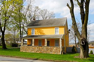
House in Toughkenamon
|
|

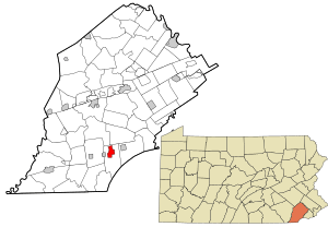
Location in Chester County and the U.S. state of Pennsylvania.
|
|
| Country | United States |
| State | Pennsylvania |
| County | Chester |
| Township | New Garden |
| Area | |
| • Total | 2.1 sq mi (5 km2) |
| • Land | 2.1 sq mi (5 km2) |
| • Water | 0.0 sq mi (0 km2) |
| Elevation | 338 ft (103 m) |
| Population
(2010)
|
|
| • Total | 1,492 |
| • Density | 710/sq mi (274/km2) |
| Time zone | UTC-5 (EST) |
| • Summer (DST) | UTC-4 (EDT) |
| ZIP code |
19374
|
| Area code(s) | 610 and 484 |
Toughkenamon is a small community in New Garden Township, Chester County, Pennsylvania. It is known as a census-designated place (CDP). This means it's an area defined for counting people by the government. In 2010, about 1,492 people lived there.
Contents
History of Toughkenamon
Early Inhabitants
Long ago, the Lenape Native Americans lived in the Toughkenamon area. They spoke a language called Unami. In 1700, an early map maker noted crossing "Dochcanamon Hill." This name was spelled in different ways over time.
First Settlers
Thomas and Mary Rowland were among the first European settlers. They arrived in 1706 and bought land near where Toughkenamon village is today. They came from another part of Chester County.
Important Beginnings
Toughkenamon was important in the early days of the United States. The way settlers and Lenape people interacted here showed what would happen in other places. For example, farmers dug ditches around their crops. They filled these with water. This was to stop fires that happened when local Lenape people did controlled burns.
These burns were an old way to help plants grow better. They also helped deer populations. The settlers knew about these burns. But later, new settlers did not understand this. They thought the fires were meant to harm their crops. This led to more mistrust with Native American families.
Quarrying and Industry
Toughkenamon Hill has been used for quarrying for hundreds of years. Quarrying is when stone is dug out of the ground.
Later, Toughkenamon became a small village. It was an early center for industry. This was because of its good location on the old Baltimore Pike. This road connected Philadelphia and Washington, D.C. The area also had easy access to wood, water, and ore. Even today, businesses that distribute food across the country are located here.
Geography of Toughkenamon
Toughkenamon is located at 39°49′48″N 75°45′32″W / 39.83000°N 75.75889°W. It covers an area of about 2.1 square miles. Most of this area is land, with a very small part being water.
Transportation in Toughkenamon
Toughkenamon is located east of Pennsylvania Route 41 in Avondale. It is on the old Baltimore Pike. This is a few miles west-southwest of Kennett Square. Major highways like Interstate 95, U.S. 1, Pennsylvania 41, and U.S. 30 can be used to reach Toughkenamon.
A railroad, the East Penn Railroad, runs alongside Baltimore Pike. It connects Toughkenamon to the national freight network. New Garden Airport is also nearby, located on Toughkenamon Hill.
Population and People
In 2020, about 1,479 people lived in Toughkenamon. There were 393 households. Many households had children under 18 living with them. The average household had about three people. The median age of people living here was 32 years old.
See also
 In Spanish: Toughkenamon para niños
 | James B. Knighten |
 | Azellia White |
 | Willa Brown |


