
Willistown Township, Pennsylvania facts for kids
Quick facts for kids
Willistown Township
|
||
|---|---|---|
|
Township
|
||

Okehocking Historic District
|
||
|
||

Location in Chester County and the state of Pennsylvania.
|
||
.svg)
Location of Pennsylvania in the United States
|
||
| Country | United States | |
| State | Pennsylvania | |
| County | Chester | |
| First Reference | 1681 | |
| Founded | 1704 | |
| Area | ||
| • Total | 18.27 sq mi (47.32 km2) | |
| • Land | 18.11 sq mi (46.90 km2) | |
| • Water | 0.16 sq mi (0.42 km2) | |
| Elevation | 351 ft (107 m) | |
| Population
(2010)
|
||
| • Total | 10,497 | |
| • Estimate
(2016)
|
10,898 | |
| • Density | 601.80/sq mi (232.36/km2) | |
| Time zone | UTC-5 (EST) | |
| • Summer (DST) | UTC-4 (EDT) | |
| Area code(s) | 610 and 484 | |
| FIPS code | 42-029-85352 | |

Willistown Township is a community located in Chester County, Pennsylvania, in the United States. In 2010, about 10,497 people lived here. The population has grown a lot over the years, from 1,521 people in 1860 to 8,269 in 1980.
Contents
History of Willistown Township
Early Beginnings and Native Americans
Long ago, the area where Willistown Township is now was home to the Lenape Native American people. In 1684, this land was part of a large area called the Welsh Tract, which was measured for William Penn. The very first time Willistown was mentioned was in a map from 1681, where it was called "Willeston." The township was officially set up in 1704.
There was once a special area for Native Americans here, and a monument now remembers it.
Old Roads and Transportation
The first roads in Willistown Township were actually trails made by Native Americans. In 1710, three important paths were created for cows: Goshen, Sugartown, and Boot. Amazingly, these roads are still used today and have the same names!
A railroad called the West Chester Railroad used to end in Malvern, which is in this township. This railroad later became part of the Pennsylvania Railroad. In 1870, the end of the line was moved to Frazer.
Historic Places to Visit
Several important places in Willistown Township are listed on the National Register of Historic Places. This means they are special and protected because of their history. Some of these places include:
- Bartram's Covered Bridge
- Garrett Farmstead
- Okehocking Historic District
- Sugartown Historic District
- White Horse Historic District
Geography and Location
Willistown Township covers about 18.2 square miles of land. It doesn't have any large bodies of water within its borders.
Neighboring Communities
Willistown Township shares its borders with several other communities. These include:
- Easttown Township
- Newtown Township
- Edgmont Township
- Westtown Township
- East Goshen Township
- East Whiteland Township
- Tredyffrin Township
- The borough of Malvern
Most homes and businesses in Willistown Township use ZIP codes 19355 and 19073. Willistown Township is also part of the Main Line, which is a suburban area west of Philadelphia.
Population and People
| Historical population | |||
|---|---|---|---|
| Census | Pop. | %± | |
| 1930 | 2,066 | — | |
| 1940 | 2,157 | 4.4% | |
| 1950 | 2,709 | 25.6% | |
| 1960 | 6,492 | 139.6% | |
| 1970 | 9,128 | 40.6% | |
| 1980 | 8,284 | −9.2% | |
| 1990 | 9,380 | 13.2% | |
| 2000 | 10,001 | 6.6% | |
| 2010 | 10,497 | 5.0% | |
| 2020 | 11,273 | 7.4% | |
In 2010, most people living in the township were White (92.0%). There were also people who were Black or African American (2.1%), Asian (3.6%), and those from two or more races (0.8%). About 1.5% of the population had Hispanic or Latino family backgrounds.
In 2000, there were 10,011 people living in Willistown. The average household had about 2.55 people, and the average family had about 2.97 people.
Age and Income
The population in 2000 was spread out by age:
- 23.4% were under 18 years old.
- 4.4% were between 18 and 24.
- 26.2% were between 25 and 44.
- 30.3% were between 45 and 64.
- 15.7% were 65 years or older.
The average age of people in the township was 43 years.
In 2000, the average income for a household was $77,555. For families, the average income was $93,057. By 2009, this number had grown to $121,726.
Transportation in Willistown
_from_the_overpass_for_the_rail_line_between_West_Central_Avenue_and_East_King_Street_in_Willistown_Township,_Chester_County,_Pennsylvania.jpg)
As of 2021, Willistown Township has about 84.26 miles of public roads. The Pennsylvania Department of Transportation (PennDOT) takes care of 27.46 miles of these roads, and the township itself maintains the other 56.80 miles.
Major Roads
- U.S. Route 30: This is the most important highway in Willistown Township. It runs east to west along Lancaster Avenue in the northern part of the township.
- Pennsylvania Route 3: This road, also known as West Chester Pike, runs east to west through the southern part of the township.
- Pennsylvania Route 926: This route starts at PA 3 and goes southwest along Street Road in the southern corner of the township.
Notable People from Willistown
Some well-known people have lived in Willistown Township:
- William Evans (1831–1905), who was a member of the Pennsylvania House of Representatives.
- Nathaniel Grubb, who was a member of the Pennsylvania Colonial Assembly.
- M. Night Shyamalan, a famous filmmaker and actor.
- Edward L. Stokes (1880-1964), who was a U.S. Congressman.
Education
The schools in Willistown Township are part of the Great Valley School District.
Images for kids
-
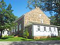
Willistown Friends Meeting House. Meeting founded in 1753. This building constructed in 1798
-
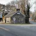
Building at the junction of Goshen and Providence Roads designed by architects, Richard Brognard (father) and Charles (son) Okie.


See also
 In Spanish: Municipio de Willistown para niños
