
Newtown Township, Delaware County, Pennsylvania facts for kids
Quick facts for kids
Newtown Township
|
||
|---|---|---|
|
Township
|
||

The Square Tavern
|
||
|
||

Location in Delaware County and the state of Pennsylvania
|
||
.svg)
Location of Pennsylvania in the United States
|
||
| Country | United States | |
| State | Pennsylvania | |
| County | Delaware | |
| Settled | 1681 | |
| Incorporated | 1684 | |
| Area | ||
| • Total | 10.09 sq mi (26.13 km2) | |
| • Land | 10.02 sq mi (25.95 km2) | |
| • Water | 0.07 sq mi (0.19 km2) | |
| Elevation | 384 ft (117 m) | |
| Population
(2020)
|
||
| • Total | 15,002 | |
| • Density | 1,486.81/sq mi (578.11/km2) | |
| Time zone | UTC-5 (EST) | |
| • Summer (DST) | UTC-4 (EDT) | |
| ZIP Code |
19073
|
|
| Area codes | 610 and 484 | |
| FIPS code | 42-045-54224 | |

Newtown Township, also known as Newtown Square, is a community in Delaware County, Pennsylvania, United States. It was once part of Chester County until 1789. In 2020, about 15,002 people lived there.
Contents
History of Newtown Township
The first time Newtown Township was mentioned was in 1684. At that time, two people were chosen to collect taxes for the "cort house and Prison for ye Township of Newtowne." The area was called Newtown Square. Many of the first settlers were Welsh people. These Welsh "Friends" (also known as Quakers) needed a road to get to their meetings.
The only road back then was Newtown Street Road, which went north and south. So, in 1687, an east-west road called Goshen Road was built. This helped the Quakers go to their meetings. By 1696, there were enough Quakers to have their own meeting in Newtown. They met in a private home until the Newtown Square Friends Meetinghouse was finished in 1711.
In the 1700s, Newtown was mostly a farming area. Shops for blacksmiths and wheelwrights opened on the main roads. These shops helped people traveling with horses and buggies. Taverns and inns also opened. They served local people and travelers taking their farm animals to markets in Philadelphia.
During the Revolutionary War, British soldiers visited Newtown Township several times. They were looking for food and supplies. General Potter had an outpost and headquarters on Goshen Road, west of Newtown Square.
In the 1800s, many mills were built along Crum Creek and Darby Creek. These mills included places that cut wood, made paper, and produced wool. Near Darby Creek, houses were built for mill workers. There was also a general store for their needs.
By 1860, Newtown Township had 830 people. Philadelphia, a larger city, had about half a million people. Railroads were being built from Philadelphia to many towns, but not to Newtown Square. As other towns grew, businesses in Newtown Square slowed down. By 1890, the population dropped to 648.
Throughout the 1800s, stone farmhouses were common in the countryside. Families added to their homes as they grew. More space was also needed for workers and farm buildings.
In the late 1800s, several hunt clubs were started near the township. These clubs attracted wealthy people from Philadelphia. They built large country homes in Newtown Square. Major changes in transportation came in the mid-1890s. Trolley service began in Newtown Square.
In 1894, a trolley pulled by mules started running. Soon after, in 1895, the trolley became electric. It connected Newtown to Fernwood. By 1899, the trolley line reached West Chester.
In the early 1900s, cars became popular. This allowed more people to move from cities to the countryside. Trolleys and cars changed farmers into people who traveled to work in the city. Farms were sold and divided into smaller plots for homes. Newtown Square grew quickly. Even though building slowed during the Great Depression, there was another big growth after World War II.
Today, Newtown Township covers about 10.11 square miles (26.13 km2). It has a population of 15,002 people. Some farms and large estates still exist. But mostly, Newtown Township is now a suburban community. Old stone homes and buildings remind everyone of its long history.
Historic Places to Visit
Newtown has five places listed on the National Register of Historic Places. These are important sites that have been preserved.
- Hood Octagonal School (built 1842) – This was the last eight-sided one-room schoolhouse in Delaware County. You can find it on West Chester Pike at Dunwoody Village.
- Bartram's Covered Bridge (built 1860) – This is the last covered bridge left in Delaware County. It crosses Crum Creek and connects to Chester County. It was fixed up in 1996.
- Old St. David's Church (built 1715) – This is the oldest non-Quaker church in Delaware County. It was started by Welsh Anglicans. General "Mad" Anthony Wayne, a hero from the Revolutionary War, is buried here. The poet Henry Wadsworth Longfellow visited in 1880 and wrote a poem about it.
- Square Tavern (built 1742) – Also known as "The Square Inn," this was the childhood home of the famous American painter Benjamin West. It has been restored several times. It is located at the corner of Newtown Street Road (Route 252) and Goshen Roads.
- Paper Mill House (built 1770, 1845) – This building was once a home for mill workers and a general store. It was restored in the 1980s. Now, it is a museum and the main office for the Newtown Square Historical Society.
Population Information
| Historical population | |||
|---|---|---|---|
| Census | Pop. | %± | |
| 1930 | 1,541 | — | |
| 1940 | 1,949 | 26.5% | |
| 1950 | 3,518 | 80.5% | |
| 1960 | 9,270 | 163.5% | |
| 1970 | 11,081 | 19.5% | |
| 1980 | 11,775 | 6.3% | |
| 1990 | 11,366 | −3.5% | |
| 2000 | 11,700 | 2.9% | |
| 2010 | 12,216 | 4.4% | |
| 2020 | 15,002 | 22.8% | |
Newtown Township has grown quite a bit over the years. In 1930, there were about 1,541 people living here. By 2020, the population had grown to 15,002 people. This shows how the community has changed and expanded.
Geography and Climate
Newtown Township covers about 10.1 square miles (26.1 square kilometers). Most of this area is land, with a small part being water. Some small communities within the township include Echo Valley, Florida Park, Larchmont, Newtown Square, and Wyola.
Neighboring Towns
Newtown Township shares its borders with several other towns:
- Radnor Township to the northeast
- Marple Township to the southeast
- Upper Providence Township to the south
- Edgmont Township to the southwest
- Willistown Township, Chester County to the west
- Easttown Township, Chester County to the northwest
The township has two main waterways: Crum Creek and Darby Creek. Springton Lake is also located to the south of the township.
Climate
Newtown Township has a climate with hot summers. The average temperature changes throughout the year. Summers are warm, and winters are cold.
Getting Around (Transportation)
Newtown Township has many public roads. Some are kept up by the Pennsylvania Department of Transportation (PennDOT). Others are maintained by the township itself.
The main east-west road is Pennsylvania Route 3, also known as West Chester Pike. It goes west to West Chester and east to Philadelphia. The main north-south road is Pennsylvania Route 252, called Newtown Street Road. It goes south to Media and north to Paoli. These two important roads meet in Newtown Square.
SEPTA provides bus service in Newtown Township. Several bus routes connect the township to other places. For example, Route 104 travels along West Chester Pike. It goes between West Chester and a transportation center in Upper Darby. Other routes connect to places like Delaware County Community College and the Philadelphia International Airport.
Newtown Township used to have train service. The Newtown Square Branch of the Pennsylvania Railroad served the area. However, train service to Newtown Square stopped in 1963. The tracks were removed in 1985. Before the buses, a trolley service connected West Chester to Philadelphia. This trolley ran from 1898 to the 1950s.
Arts and Culture
Newtown Township is home to several places of worship. St. David's Episcopal Church is partly in Newtown and partly in Radnor Township. Its graveyard and buildings date back to 1715. It is listed on the National Register of Historic Places. The graveyard holds the grave of Revolutionary War hero General Mad Anthony Wayne.
The Newtown Square Friends Meeting House and Burying Ground is the oldest place of worship in Newtown. The original Quaker settlers built the Meeting House in 1711. It was made larger in 1791. You can still see parts of the original 1711 building in the stone walls. The Meeting House is still used for worship today.
Saint Anastasia Parish was started in 1912 for the Catholic community. A Catholic school opened in 1930. After World War II, the church and school grew. They served the increasing Catholic population in Newtown Square.
Education
Newtown Township is part of the Marple Newtown School District. This district also includes Marple Township. The district has four elementary schools, one middle school, and one high school. Culbertson Elementary School is the only elementary school located in Newtown Township. Marple Newtown Senior High School is also within the township.
There are also many private schools in Newtown Township. These include Episcopal Academy and Delaware County Christian School. The township also has its own public library, the Newtown Public Library.
Economy
Newtown Township is home to several important companies and organizations. The Project Management Institute (PMI) is located here. There is also a technology center for Lyondell Chemical Company. Apple Leisure Group, which includes Apple Vacations, also has its headquarters in the township.
The main office for SAP America is in Newtown. SAP America is a part of SAP SE, a large software company. About 3,000 people work for SAP America in this area.
Attractions
The Newtown Square Railroad Museum is a fun place to visit. It is located inside the old Newtown Square Station. The museum has a small model train layout. It also features an old trolley and a vintage steam locomotive. You can see other items that tell the story of the Newtown Square Branch railroad.
Newtown in Popular Culture
The Du Pont family's Foxcatcher Farm estate was located in Newtown. This estate was featured in the 2014 film Foxcatcher.
Aronimink Golf Club is a very famous golf course in Newtown Square. It is known as one of the best golf courses in the country. The club has hosted many major golf tournaments. These include the 1962 PGA Championship, the BMW Championship in 2018, and the Women's PGA Championship in 2020. It is also set to host the PGA Championship again in 2026.
Notable People
Many interesting people were born or lived in Newtown Township:
- Michael Barkann: A sports host and reporter for NBC Sports Philadelphia.
- Smedley Butler: A U.S. Marine Corps general who won the Medal of Honor twice. He was also an anti-war activist.
- Pat Chambers: A college basketball coach. He used to coach at Penn State.
- Joey Crawford: A basketball referee for the NBA for many years.
- John Anderson Fry: The current president of Drexel University.
- Cole Hamels: A professional baseball pitcher who played for the Philadelphia Phillies.
- Edward Hunter: The third Presiding Bishop of the Church of Jesus Christ of Latter-day Saints.
- Willem Johan Kolff: A Dutch-American inventor who helped create the artificial heart.
- Bill Maas: A former American football player for the Kansas City Chiefs.
- Sean Payton: An American football head coach for the Denver Broncos. He lived in Newtown during elementary and middle school.
- Benjamin West: A famous British-American artist. He grew up in Newtown, and his father owned the Square Tavern.
Images for kids
-
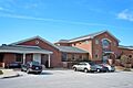
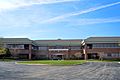
The Municipal Building and library in Newtown Township.
-
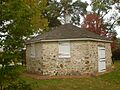
The historic Octagonal School House.
-
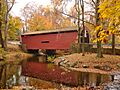
Bartram's Covered Bridge, a historic covered bridge over Crum Creek.
-
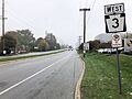
Pennsylvania State Route 3 (West Chester Pike) in Newtown Township.
-
The headquarters of Apple Leisure Group in Newtown Square.


_just_west_of_Boot_Road_in_Newtown_Township,_Delaware_County,_Pennsylvania.jpg)

See also
 In Spanish: Municipio de Newtown (condado de Delaware) para niños
