
Pennsylvania Route 3 facts for kids
Quick facts for kids
|
||||
|---|---|---|---|---|
| Route information | ||||
| Maintained by PennDOT, Borough of West Chester, and City of Philadelphia | ||||
| Length | 24.326 mi (39.149 km) | |||
| Existed | 1937–present | |||
| Major junctions | ||||
| West end | ||||
| East end | ||||
| Location | ||||
| Counties: | Chester, Delaware, Philadelphia | |||
| Highway system | ||||
| Roads in Pennsylvania Interstate • US • State • Legislative
|
||||

Pennsylvania Route 3 (PA 3) is a state highway in southeastern Pennsylvania. It is about 24.3 miles (39.1 km) long. This road connects U.S. Route 322 Business (US 322 Bus.) in West Chester with PA 611 in Philadelphia.
The route starts in downtown West Chester. It then heads east, sometimes using a "one-way pair" of streets. This means traffic goes in opposite directions on two nearby streets. Between West Chester and Upper Darby, PA 3 is a four-lane divided highway called West Chester Pike. It goes through suburban towns like Newtown Square and Havertown.
In Upper Darby, PA 3 becomes Market Street and enters Philadelphia. In Philadelphia, it uses more one-way pairs. For example, it runs along Chestnut Street for eastbound traffic and Walnut Street for westbound traffic in West Philadelphia. It ends near Philadelphia City Hall.
This road has a long history. A dirt road linked Philadelphia and West Chester as early as 1793. Later, a company built a toll road (where you pay to use it) in 1848. This road was first made of planks, then stone. Trolleys (like electric streetcars) ran along parts of it in the 1890s. The state took over the road in 1918. PA 3 officially got its current name and route in 1937.
Contents
Exploring PA 3: A Road Trip Guide
Starting in West Chester: Chester County's Charm
PA 3 begins in West Chester, a town in Chester County. It starts at an intersection with US 322 Bus. (High Street). This is near the historic Chester County Courthouse.
From here, PA 3 uses a "one-way pair" of streets. Eastbound traffic goes on East Market Street, and westbound traffic uses East Chestnut Street. These streets have two lanes in each direction. They pass by many downtown shops and businesses.
Later, the westbound PA 3 shifts to East Gay Street. Both directions continue through commercial areas. They pass the West Chester Railroad station.
Heading East: Suburban Journeys
PA 3 leaves West Chester and enters West Goshen Township. Here, both directions of the route come together. They form a four-lane "divided highway" called West Chester Pike. A divided highway has a barrier or space separating traffic going in opposite directions.
The road passes through homes and businesses. It has an interchange (a special type of intersection) with the US 202/US 322 freeway. PA 3 then enters East Goshen Township. It continues past suburban neighborhoods.
In Westtown Township, PA 3 meets PA 352. They share the road for a short distance, which is called a "concurrency." Then PA 352 splits off. The road goes through wooded areas with homes.

PA 3 continues into Willistown Township. It crosses Ridley Creek. The road then enters Edgmont Township in Delaware County. It passes north of Ridley Creek State Park.
Through Delaware County: Towns and Highways
The route continues east, passing homes and businesses. It crosses Crum Creek into Newtown Township. Here, it passes the Delaware County Veterans Memorial.
PA 3 then enters business areas. It meets PA 252 in Newtown Square. After this, it continues through suburban areas.

The road crosses into Marple Township. It then meets PA 320 in Broomall. PA 3 continues near suburban neighborhoods. It then has an interchange with I-476.
After the I-476 interchange, PA 3 crosses Darby Creek. It enters Haverford Township. The road goes through Havertown. It passes homes and businesses.
Farther east, PA 3 crosses Naylors Run. It then enters Upper Darby Township. Here, it continues past suburban businesses and homes.

In Upper Darby, SEPTA (Southeastern Pennsylvania Transportation Authority) trolley tracks begin running in the middle of the road. PA 3 then heads east on Market Street. It passes the 69th Street Transportation Center. The route then becomes the border between Millbourne and Upper Darby Township.
Into Philadelphia: City Streets
PA 3 crosses Cobbs Creek and enters the big city of Philadelphia in Philadelphia County. It immediately splits from Market Street. It turns south onto Cobbs Creek Parkway.
The route then splits into another one-way pair. Eastbound PA 3 follows Chestnut Street. Westbound PA 3 follows Walnut Street, one block south. These streets go through residential areas of West Philadelphia. They pass many rowhomes (houses built in a row) and some businesses.
The streets reach the University City neighborhood. Here, Walnut Street runs along the edge of the University of Pennsylvania campus. The streets cross SEPTA trolley tracks.
Westbound PA 3 then shifts to Market Street. It runs with US 13 for a short time. Eastbound PA 3 continues on Chestnut Street. The route passes many tall commercial buildings. It runs through part of the Drexel University campus. At 33rd Street, eastbound PA 3 turns north and joins the westbound direction on Market Street.

At 32nd Street, PA 3 splits into another one-way pair. Eastbound PA 3 continues on Market Street. Westbound PA 3 follows John F. Kennedy Boulevard. Both are two-way streets.
The route passes under CSX train tracks. It then comes to the 30th Street intersection near 30th Street Station. This station is a major hub for trains. Immediately east of 30th Street Station, PA 3 has an interchange with I-76. It then crosses over the Schuylkill River.
At this point, PA 3 enters Center City Philadelphia. It continues on Market Street eastbound and John F. Kennedy Boulevard westbound. These streets pass many tall downtown skyscrapers.
At 20th Street, both directions of PA 3 become one-way streets. Market Street carries eastbound traffic, and John F. Kennedy Boulevard carries westbound traffic. PA 3 reaches its eastern end at PA 611 (Broad Street) at 15th Street. This is near Philadelphia City Hall.
A Look Back: The History of PA 3
From Dirt Roads to Trolleys

For many years, from 1793 to 1850, Philadelphia and West Chester were connected by a simple dirt road. People used horse-drawn carriages and wagons on it.
In March 1848, a company was formed to build a "turnpike" between Philadelphia and Newtown Square. A turnpike is a toll road, meaning you had to pay a fee to use it. This road was called the Philadelphia and West Chester Turnpike. It was built to help farming and manufacturing in Delaware County.
Between 1850 and 1868, the turnpike was a "plank road." This meant it was made of wooden planks. By 1885, the entire turnpike became a stone road.
Train service started on the turnpike in 1859. A horse-drawn rail line was built from Philadelphia to Upper Darby. Later, in 1895, a "trolley" service began. Trolleys are electric streetcars that run on tracks. They were first powered by steam, then by electricity. The trolley line was extended to West Chester in 1898.
In 1918, the state took over the West Chester Pike. The tolls were removed, making it a free road.
Naming the Route: PA 3's Journey
The West Chester Pike was first named Legislative Route 133 in 1911. In 1927, it became part of PA 5. This route was part of a larger road called the Lakes-to-Sea Highway.
In 1937, PA 3 was officially created. It took over the route between West Chester and Philadelphia, replacing the PA 5 name.
Modernizing the Road: Widening and Changes
The section of PA 3 known as John F. Kennedy Boulevard was once called Filbert Street. This area used to have a large train viaduct (a long bridge-like structure) that carried many train tracks. This viaduct was so big it was nicknamed the "Chinese Wall." It separated parts of the city.
In the 1950s, this "Chinese Wall" and the old train station were taken down. A wide new street, Pennsylvania Boulevard, was built in its place. This area became a business district called Penn Center. Pennsylvania Boulevard was later renamed John F. Kennedy Boulevard.
_on_Ardmore_Rail_Division_along_West_Chester_Pike,_near_Llanerch_Shops_in_Upper_Darby,_August_1964.jpg)
In 1954, regular trolley service between Philadelphia and West Chester stopped. This was done to allow PA 3 to be widened. Buses replaced the trolleys. Today, this bus service is part of SEPTA's Route 104.
During the mid-1950s and early 1960s, the West Chester Pike part of PA 3 was widened to four lanes. By 1960, PA 3's route in Philadelphia changed. It was rerouted to end at US 13 in Southwest Philadelphia. By the 1970s, PA 3 was extended east to Philadelphia City Hall.
In 2012, a section of PA 3 in West Chester was named the Robert J. Thompson Highway. This was done to honor former State Senator Robert J. Thompson.
Major Intersections
| County | Location | mi | km | Destinations | Notes |
|---|---|---|---|---|---|
| Chester | West Chester | 0.000 | 0.000 | Western terminus | |
| West Goshen Township | 0.805 | 1.296 | Paoli Pike | Eastbound exit and westbound entrance | |
| 1.338 | 2.153 | Interchange | |||
| Westtown Township | 4.518 | 7.271 | Western terminus of concurrency with PA 352 | ||
| 4.648 | 7.480 | Eastern terminus of concurrency with PA 352 | |||
| Willistown Township | 6.338 | 10.200 | Eastern terminus of PA 926 | ||
| Delaware | Newtown Township | 11.308 | 18.198 | ||
| Marple Township | 13.456 | 21.655 | |||
| 14.560 | 23.432 | Exit 9 on I-476 | |||
| Haverford–Upper Darby township line |
17.117 | 27.547 | |||
| Philadelphia | Philadelphia | 22.451 | 36.131 | Brief concurrency between westbound PA 3 and US 13 | |
| 23.321 | 37.532 | Exit 345 on I-76; access via Schuylkill Avenue | |||
| 24.326 | 39.149 | Penn Square; eastern terminus | |||
| 1.000 mi = 1.609 km; 1.000 km = 0.621 mi | |||||
Images for kids
-
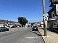
PA 3 eastbound in Upper Darby, with the Philadelphia skyline in the distance
-
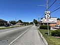
PA 3 westbound in Havertown


