Downingtown, Pennsylvania facts for kids
Quick facts for kids
Downingtown, Pennsylvania
|
|
|---|---|
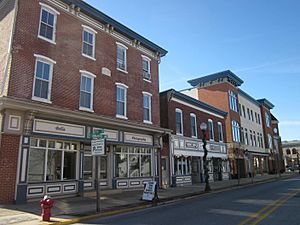
Lancaster Avenue
|
|
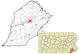
Location in Chester County and the U.S. state of Pennsylvania
|
|
| Country | United States |
| State | Pennsylvania |
| County | Chester |
| Incorporated | May 12, 1859 |
| Area | |
| • Total | 2.22 sq mi (5.76 km2) |
| • Land | 2.19 sq mi (5.67 km2) |
| • Water | 0.04 sq mi (0.09 km2) |
| Elevation | 239 ft (73 m) |
| Population
(2020)
|
|
| • Total | 7,892 |
| • Density | 3,606.95/sq mi (1,392.73/km2) |
| Time zone | UTC-5 (EST) |
| • Summer (DST) | UTC-4 (EDT) |
| ZIP codes |
19335, 19372
|
| Area codes | 610, 484, and 835 |
| FIPS code | 42-19752 |
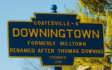
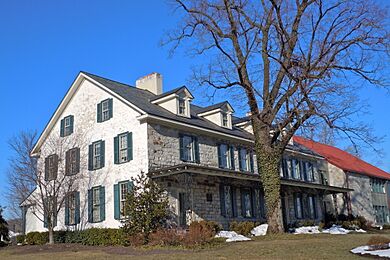
Downingtown is a small town, called a borough, in Chester County, Pennsylvania. It is about 33 miles (53 km) west of Philadelphia. In 2020, about 7,898 people lived there. European settlers first came to Downingtown in 1716. The town has many old and important buildings.
Contents
History of Downingtown
How Downingtown Got Its Name
This borough was first called Milltown. This was because it had many mills along the East Branch Brandywine Creek. The first mill was started by Daniel Butter. His family also owned paper mills. Later, Frederick Bicking helped start more paper businesses.
Around the time of the American Revolution, the town became known as Downingtown. This name came from Thomas Downing, a successful businessman. He was a Quaker who moved from England in 1717. Thomas Downing owned many of the mills. The town was officially named Downingtown in 1812.
Important Roads and Travel
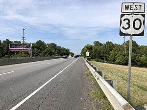
Downingtown is on the Lincoln Highway. This road is now part of U.S. Route 30. The Lincoln Highway was the first paved road to cross the entire United States. It went from the Atlantic Ocean to the Pacific Ocean.
Before that, it was an important wagon road called the Philadelphia and Lancaster Turnpike. In the 1940s, the Pennsylvania Turnpike was built. It goes north of US 30 and bypasses Downingtown.
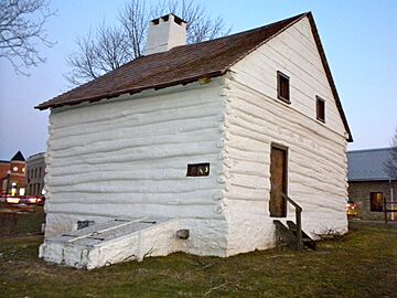
The Downingtown Log House
Around 1700, early English settlers built the Downingtown Log House. In 1713, Joseph Hickman sold this small, one-and-a-half-story house. Thomas Downing bought the Log House in 1739. It stayed in his family until 1940. Then, Thomas W. Downing left it to the borough of Downingtown.
The borough worked to fix up the house in 1947. It was the home of the Downingtown Chamber of Commerce from 1950 to 1988. But the house started to fall apart. This was because Route 30 was built very close to it. The house was below street level, so water from the road damaged it. Traffic vibrations also made the building weak.
From 1988 to 1990, the Downingtown Historical Society moved the house. They used money raised to fix it completely. Now, it is about 70 feet (21 m) west of its first spot. It is also 22 feet (6.7 m) from the Route 30 sidewalk and a bit above street level.
Downingtown Industrial and Agricultural School
In 1904, John S. Trower and William A. Creditt started a special school. They were important Black leaders from Philadelphia. The school was called the Downingtown Industrial and Agricultural School (DIAS). It was a high school for African-American young people. It taught them academic subjects and job skills.
Creditt was a pastor, and Trower was a very successful businessman. They believed a school like the Tuskegee Institute was needed in the North. They found land in Chester County and built the school on 100 acres. Both men led the school until they passed away in 1921. At first, it was a private school. In 1907, it started getting money from the state. Students came from big cities in the Northeast. The school closed in 1993. A new building was built there in 2002. It is now the Chester County campus of the Delaware County Community College.
Modern Downingtown
The borough has been working to improve its downtown area. Many old buildings have been fixed up. New homes have also been built on old industrial land. Downingtown is home to some big businesses. These include First National Bank of Chester County and Victory Brewing Company.
Some famous people have connections to Downingtown. President Lincoln's funeral train passed through the town. The Irish hero Theobald Wolfe Tone lived here for a short time in 1795.
Several historic places in Downingtown are listed on the National Register of Historic Places. These include the County Bridge No. 124, the Downingtown Log House, the East Lancaster Avenue Historic District, the General Washington Inn, and the Roger Hunt Mill.
Geography
Downingtown is located at 40°0′23″N 75°42′22″W / 40.00639°N 75.70611°W. The United States Census Bureau says the borough covers about 2.2 square miles (5.7 km²). All of this area is land.
Population Information
| Historical population | |||
|---|---|---|---|
| Census | Pop. | %± | |
| 1860 | 761 | — | |
| 1870 | 1,077 | 41.5% | |
| 1880 | 1,480 | 37.4% | |
| 1890 | 1,920 | 29.7% | |
| 1900 | 2,133 | 11.1% | |
| 1910 | 3,326 | 55.9% | |
| 1920 | 4,024 | 21.0% | |
| 1930 | 4,548 | 13.0% | |
| 1940 | 4,645 | 2.1% | |
| 1950 | 4,948 | 6.5% | |
| 1960 | 5,598 | 13.1% | |
| 1970 | 7,437 | 32.9% | |
| 1980 | 7,650 | 2.9% | |
| 1990 | 7,749 | 1.3% | |
| 2000 | 7,589 | −2.1% | |
| 2010 | 7,891 | 4.0% | |
| 2020 | 7,898 | 0.1% | |
| 2021 (est.) | 8,162 | 3.4% | |
| Sources: | |||
In 2010, about 76% of the people in Downingtown were White. About 12% were Black or African American. Around 2.7% were Asian. About 7.2% of the population had Hispanic or Latino family backgrounds.
In 2000, there were 7,589 people living in Downingtown. There were 3,059 households. About 31.4% of households had children under 18. The average household had 2.40 people.
Downingtown has many residents with Italian family roots. The town has two Italian American groups. It is known as a place with a strong Italian-American community in the U.S.
Climate
Downingtown has a humid continental climate. This means it has warm, humid summers and cold winters.
| Climate data for Downingtown, Pennsylvania | |||||||||||||
|---|---|---|---|---|---|---|---|---|---|---|---|---|---|
| Month | Jan | Feb | Mar | Apr | May | Jun | Jul | Aug | Sep | Oct | Nov | Dec | Year |
| Mean daily maximum °C (°F) | 4 (39) |
6 (42) |
11 (51) |
16 (61) |
22 (72) |
27 (80) |
29 (85) |
28 (83) |
24 (76) |
18 (65) |
12 (53) |
7 (44) |
16 (61) |
| Mean daily minimum °C (°F) | −6 (21) |
−5 (23) |
−1 (30) |
4 (39) |
9 (48) |
15 (59) |
18 (64) |
17 (62) |
12 (54) |
6 (42) |
1 (34) |
−3 (26) |
8 (46) |
| Average precipitation mm (inches) | 91 (3.6) |
84 (3.3) |
97 (3.8) |
94 (3.7) |
99 (3.9) |
110 (4.5) |
110 (4.4) |
110 (4.5) |
94 (3.7) |
84 (3.3) |
84 (3.3) |
97 (3.8) |
1,160 (45.8) |
| Source: Weatherbase | |||||||||||||
Education
Public Schools
The Downingtown Area School District (DASD) runs the public schools in the borough. Four elementary schools serve parts of Downingtown:
- Beaver Creek Elementary (in the borough)
- East Ward Elementary (in the borough)
- Bradford Heights Elementary
- Uwchlan Hills Elementary
Other elementary schools in the nearby area include Brandywine Wallace, Lionville, Shamona Creek, Pickering Valley, Springton Manor, and West Bradford.
All students in the borough go to Marsh Creek Sixth Grade Center. Most students then go to Downingtown Middle School and Downingtown West High School. Some eastern parts of the borough go to Lionville Middle School and Downingtown East High School.
- Downingtown S.T.E.M. Academy is also located in the borough.
Other Schools
The Roman Catholic Archdiocese of Philadelphia has two schools in Downingtown:
- Bishop Shanahan High School
- St Joseph School Parish School K-8 (in the borough)
Other schools in the area include:
- Chester County Intermediate Unit (offices and special services)
- Collegium Charter School
- Creative Kids Of Downingtown
- Devereux Day School-cares (in the borough)
- Kindercare Learning Center
- 21st Century Cyber Charter School
College Education
Delaware County Community College has its Brandywine Campus in Downingtown. It also has the Downingtown Campus in East Brandywine Township, Chester County, Pennsylvania. This campus is on the land where the old Downingtown Industrial and Agricultural School used to be.
Transportation
Roads
In 2012, Downingtown had 22.32 miles (35.92 km) of public roads. The Pennsylvania Department of Transportation (PennDOT) maintained 6.36 miles (10.24 km). The borough maintained 15.96 miles (25.69 km).
U.S. Route 30 is the main highway. It runs through the northern part of the borough. U.S. Route 30 Business goes through the center of town. U.S. Route 322 also passes through the borough. Pennsylvania Route 113 and Pennsylvania Route 282 start in Downingtown and head north.
Public Transit
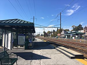
The Downingtown station is on the Lincoln Highway. You can catch SEPTA Regional Rail's Paoli/Thorndale Line and Amtrak's Keystone Service trains here. The town also has SEPTA Suburban Bus Route 135. This bus goes between Coatesville and West Chester.
Notable People
- John P. Edge (1822–1904), a doctor and politician.
- Thomas Buchanan Read (1822-1872), a poet and painter.
- Miles Teller (born 1987), an actor.
- Elijah Wilkinson (born 1995), a professional football player.
- Dave Days (born 1991), a musician and internet personality.
- Tyler Kroft (born 1992), a professional football player.
- Jeff Parke (born 1982), a former professional soccer player.
See also
 In Spanish: Downingtown para niños
 | Mary Eliza Mahoney |
 | Susie King Taylor |
 | Ida Gray |
 | Eliza Ann Grier |


