
Coatesville, Pennsylvania facts for kids
Quick facts for kids
Coatesville, Pennsylvania
|
|||
|---|---|---|---|

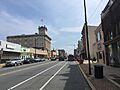
Lincoln Highway in Coatesville
|
|||
|
|||

Location in Chester County and the U.S. state of Pennsylvania.
|
|||

Coatesville, Pennsylvania
Location in Pennsylvania

Coatesville, Pennsylvania
Location in the United States
|
|||
| Country | United States | ||
| State | Pennsylvania | ||
| Pennsylvania | Chester | ||
| Incorporated | 1915 | ||
| Area | |||
| • Total | 1.83 sq mi (4.73 km2) | ||
| • Land | 1.81 sq mi (4.68 km2) | ||
| • Water | 0.02 sq mi (0.05 km2) | ||
| Elevation | 331 ft (101 m) | ||
| Population
(2020)
|
|||
| • Total | 13,350 | ||
| • Density | 7,383.85/sq mi (2,850.18/km2) | ||
| Time zone | UTC-5 (EST) | ||
| • Summer (DST) | UTC-4 (EDT) | ||
| ZIP Code |
19320
|
||
| Area code(s) | 610 and 484 | ||
| FIPS code | 42-14712 | ||


Coatesville is a city in Chester County, Pennsylvania, United States. It is the only city in the county. In 2020, about 13,350 people lived there. Coatesville is located about 39 miles west of Philadelphia. It grew along the Philadelphia and Lancaster Turnpike starting in the late 1700s. The city is also on U.S. Route 30, a major highway west of Philadelphia.
In the early 1900s, Coatesville grew because of the Lukens Steel Company and other factories. However, as industries changed, many jobs were lost, and the city's population went down. Lukens Steel was bought by Bethlehem Steel in 1997. Later, it became part of ArcelorMittal, and then Cleveland-Cliffs bought its U.S. operations in 2020.
Contents
History of Coatesville
Early Settlements
Different groups of Native Americans lived in this area for a long time. The first known settlement was a Lenape village. It was built along the West Branch of the Brandywine River. This village was a trading post where Native Americans and early American settlers exchanged furs. The Brandywine River has always been important to Coatesville's history.
William Fleming, from Scotland, was one of the first landowners here. He built a log cabin and owned about 207 acres of land near the Brandywine River.
Moses Coates, a successful farmer, bought the cabin in 1787. Coatesville is named after him. After the United States became independent, Moses Coates' son-in-law, Jesse Kersey, had an idea. He wanted to sell land along the new Lancaster Turnpike. This turnpike was the first toll road in the U.S., finished in 1795. A tollgate was even located within Coatesville. Because Coatesville was halfway between Philadelphia and Lancaster, it became a popular stop for travelers.
Pierre Bizallion, a French fur trader, also lived here in the early 1700s. He helped William Penn talk with Native American groups. Today, the Veterans Administration Hospital is on a large part of the land he once owned.
Growth in the 1800s
Before it became a city, Coatesville was called Bridge-Town. This name came from the two bridges that crossed the Brandywine River. In 1834, a village called "Midway" formed on the west side of the Brandywine. It was named Midway because its train station was halfway between Philadelphia and Lancaster. In 1867, Bridge-Town and Midway joined to become the borough of Coatesville. Coatesville officially became a city in 1915.
Coatesville used the power of the Brandywine River for its industries. In 1810, Jesse Kersey and Isaac Pennock bought land along the river. They started the Brandywine Iron Works and Nail Factory. This factory later became Lukens Steel. After her husband's death in 1825, Rebecca Lukens took over the mill. She was one of the first women to run a major company in the United States. She helped the mill grow and succeed.
The 1900s and Industry Changes

As Lukens Steel grew, so did Coatesville. It became known as the "Pittsburgh of the East." By the early 1900s, the population reached 6,000. Many immigrants from Europe and people from the southern U.S. moved there for factory jobs.
In 1911, a serious event happened in Coatesville. An African-American steelworker named Zachariah Walker was killed by a mob. He was accused of harming a local officer. This event was the last of its kind in Pennsylvania. It led to the National Association for the Advancement of Colored People (NAACP) working to stop such violence across the country. Pennsylvania passed a law against such acts in 1923.
In 1919, during a time of racial tension across America, the African-American community in Coatesville took action. They formed a large group to protect themselves from possible harm.
In 1929, the Coatesville VA Medical Center was built. It first helped veterans with mental health needs. In 2013, this Medical Center was added to the National Register of Historic Places because of its special architecture. Today, it helps over 19,000 veterans in Pennsylvania and Delaware.
The city's school system also grew, and more churches and a synagogue were built. By 1932, there were 22 churches in Coatesville.
After World War II, the steel industry started to decline. However, in the 1960s, Lukens Steel was still the biggest employer in Chester County, with over 10,000 workers. Over time, the company changed hands and reduced its workforce.
Coatesville in the 2000s

Since 2000, Coatesville has worked to rebuild and improve the city. Old public housing has been replaced with new homes. A new Marriott Courtyard hotel opened in 2012.
Some redevelopment plans caused disagreements. For example, there was a long dispute about land ownership. This led to voters choosing new city council members in 2005.
Between 2007 and 2009, Coatesville experienced a series of fires. These fires caused a lot of damage and left many people without homes. Police arrested several suspects, and some were sentenced for their roles in the fires.
In 1969, Lukens Steel made the steel beams for the World Trade Center in New York City. After the 9/11 Terrorist Attacks, some of these special "trident" beams remained standing. Ten of these beams were brought to Coatesville in 2010. They are now part of the National Iron and Steel Heritage Museum.
Many places in Coatesville are listed on the National Register of Historic Places. These include the Coatesville Historic District, Clement Atkinson Memorial Hospital, High Bridge, and the Coatesville Veterans Affairs Medical Center.
Geography and Climate
Coatesville covers about 1.9 square miles. A small part of this area is water.
Weather in Coatesville
Coatesville has a typical Northeast climate. Winters are cold and snowy, while summers are hot and humid.
| Climate data for Coatesville, Pennsylvania | |||||||||||||
|---|---|---|---|---|---|---|---|---|---|---|---|---|---|
| Month | Jan | Feb | Mar | Apr | May | Jun | Jul | Aug | Sep | Oct | Nov | Dec | Year |
| Mean daily maximum °C (°F) | 3.7 (38.7) |
4 (40) |
10.2 (50.4) |
16.8 (62.2) |
22.7 (72.9) |
27.4 (81.3) |
29.9 (85.8) |
28.7 (83.7) |
25.4 (77.7) |
19.1 (66.3) |
11.9 (53.4) |
5.3 (41.6) |
17.1 (62.8) |
| Mean daily minimum °C (°F) | −6.2 (20.8) |
−6.2 (20.9) |
−1.4 (29.4) |
3.8 (38.8) |
9.5 (49.1) |
14.6 (58.3) |
17.3 (63.2) |
16.3 (61.3) |
12.4 (54.3) |
5.7 (42.3) |
0.4 (32.8) |
−4.6 (23.8) |
5.1 (41.2) |
| Average precipitation mm (inches) | 91 (3.6) |
84 (3.3) |
97 (3.8) |
94 (3.7) |
99 (3.9) |
110 (4.5) |
110 (4.4) |
110 (4.5) |
94 (3.7) |
84 (3.3) |
84 (3.3) |
97 (3.8) |
1,160 (45.8) |
| Source: Weatherbase | |||||||||||||
People of Coatesville
| Historical population | |||
|---|---|---|---|
| Census | Pop. | %± | |
| 1870 | 2,025 | — | |
| 1880 | 2,766 | 36.6% | |
| 1890 | 3,680 | 33.0% | |
| 1900 | 5,721 | 55.5% | |
| 1910 | 11,084 | 93.7% | |
| 1920 | 14,515 | 31.0% | |
| 1930 | 14,582 | 0.5% | |
| 1940 | 14,006 | −4.0% | |
| 1950 | 13,826 | −1.3% | |
| 1960 | 12,971 | −6.2% | |
| 1970 | 12,331 | −4.9% | |
| 1980 | 10,698 | −13.2% | |
| 1990 | 11,038 | 3.2% | |
| 2000 | 10,838 | −1.8% | |
| 2010 | 13,100 | 20.9% | |
| 2020 | 13,350 | 1.9% | |
| U.S. Decennial Census | |||
Population Details
In 2020, Coatesville had 13,350 people. The city is home to a diverse population. About 43.9% of residents were Black or African American. About 23.5% were White. People of Hispanic or Latino background made up about 25.1% of the population.
In 2010, there were 13,100 people living in Coatesville. About 30.4% of the population was under 18 years old. The average age was 31 years.
City Government
Coatesville is a "third class city" in Pennsylvania. It uses a Council–manager government system. This means there is a city council and a city manager who runs the daily operations. There are seven council members. Five are elected from different areas (wards), and two are elected from the city as a whole.
City Council Members
As of November 2021:
| Ward | Council member | Party | Term ends |
|---|---|---|---|
| 1 | Edward Simpson | Republican | 2023 |
| 2 | Donald Folks | Democratic | 2025 |
| 3 | C. Arvilla Hunt | Democratic | 2023 |
| 4 | Carmen Green | Democratic | 2025 |
| 5 | Linda Lavender-Norris | Republican | 2023 |
| At-Large | Khadijah Al Amin | Democratic | 2025 |
| Charrisse Allen | Democratic | 2025 |
Education in Coatesville
The Coatesville Area School District serves the city. This district is responsible for the public schools in Coatesville.
Getting Around Coatesville
_just_west_of_the_exit_for_Pennsylvania_State_Route_82_in_Coatesville,_Chester_County,_Pennsylvania.jpg)
Coatesville has over 31 miles of public roads. Most of these roads are maintained by the city itself.
The main east-west road is US 30. It goes around the city and connects to Lancaster to the west and Philadelphia to the east. US 30 Business runs through the center of Coatesville. PA 82 is the main north-south road. It goes north to Elverson and south to Kennett Square.

For air travel, the Chester County G. O. Carlson Airport is about 3 miles west. It is for private and corporate planes. The closest airport with commercial flights is Philadelphia International Airport.
Coatesville has an Amtrak station. It serves Keystone Service trains. In 2019, it was announced that SEPTA train service would return to Coatesville. A new station was built near the Amtrak station. Construction was completed by 2025.
Two bus services operate in Coatesville. The Coatesville Link bus connects different places in Coatesville and Parkesburg. SEPTA Suburban Bus Route 135 connects Coatesville to nearby towns like Downingtown and West Chester.
Famous People from Coatesville
Many notable people have connections to Coatesville:
- Whittier C. Atkinson, who founded the Clement Atkinson Memorial Hospital.
- Vince Belnome, a former MLB infielder.
- Walt Downing, an NFL center for the San Francisco 49ers.
- Richard Hamilton, an NBA All-Star basketball player.
- Billy Joe, a football player who won the Super Bowl with the New York Jets.
- Ray Keech, an auto racing pioneer who won the 1929 Indianapolis 500.
- Rebecca Lukens, a pioneering businesswoman who ran Lukens Steel Company.
- Charles Moore, an Olympic champion in hurdles.
- Derrick Morgan, an NFL defensive end.
- Rod Perry, an actor known for the TV series S.W.A.T..
- Susan Richardson, an actress from the TV series Eight Is Enough.
- Zack Steffen, a professional soccer player.
- Johnny Weir, a famous figure skater and TV personality.
Legacy
In 2006, a historical marker was placed near Coatesville. It remembers the event involving Zachariah Walker.
Images for kids
-
Lincoln Highway in Coatesville
-
Flag of Coatesville, Pennsylvania
-
Seal of Coatesville, Pennsylvania
-
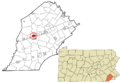
Location in Chester County and Pennsylvania
-
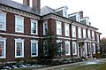
Main Office of Lukens Steel
-
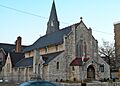
Episcopal Church of the Trinity, 323 East Lincoln Highway
-

US 30 westbound in Coatesville
-
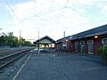
Coatesville Amtrak station
See also
 In Spanish: Coatesville (Pensilvania) para niños
