Schuylkill River facts for kids
Quick facts for kids Schuylkill River |
|
|---|---|

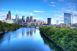
The Schuylkill River looking south toward the Philadelphia skyline
|
|

The river's watershed drains parts of the western side of Broad Mountain and the ridge-and-valley Appalachians of the southcentral Pennsylvania Coal Region.
|
|
| Country | United States |
| State | Pennsylvania |
| Counties | Philadelphia, Montgomery, Chester, Berks, Schuylkill |
| Cities | Philadelphia, Norristown, Pottstown, Reading |
| Physical characteristics | |
| Main source | East Branch Schuylkill River Tuscarora, Schuylkill County, Pennsylvania, United States 1,540 ft (470 m) 40°46′24″N 76°01′20″W / 40.77333°N 76.02222°W |
| 2nd source | West Branch Schuylkill River Minersville, Schuylkill County, Pennsylvania, United States 1,140 ft (350 m) 40°42′51″N 76°18′46″W / 40.71417°N 76.31278°W |
| River mouth | Delaware River Philadelphia, Pennsylvania, United States 0 ft (0 m) 39°53′04″N 75°11′41″W / 39.88444°N 75.19472°W |
| Length | 135 mi (217 km) |
| Discharge (location 2) |
|
| Basin features | |
| Basin size | 2,000 sq mi (5,200 km2) |
| Tributaries |
|
The Schuylkill River is an important river in the state of Pennsylvania in the United States. It is about 135 mi (217 km) long. This river flows through several counties and cities, including Philadelphia.
Long ago, the Lenape people called this river "Tool-pay Hanna". Later, Dutch explorers gave it the name "Schuylkill," which means "hidden creek" or "skulking creek." This name might have come from how the river was hard to see at its mouth.
Contents
Where Does the Schuylkill River Flow?
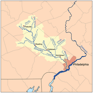
The Schuylkill River starts in Schuylkill County, Pennsylvania. It has two main starting points: the East Branch and the West Branch.
- The East Branch begins near Tuscarora.
- The West Branch starts near Minersville.
These two branches meet up in Schuylkill Haven. From there, the river flows southeast. It passes through several counties, including Berks, Chester, and Montgomery.
Cities Along the River
Many towns and cities are located along the Schuylkill River. Some of the bigger ones include:
The river finally ends in Philadelphia, where it joins the much larger Delaware River. The area of land that drains into the Schuylkill River is called its basin. This basin covers about 2,000 sq mi (5,200 km2) of land.
What Are the River's Features?
The Schuylkill River is a good size, flowing with a lot of water. In Philadelphia, the river's average flow is about 4,650 cu ft/s (132 m3/s) of water every second. This amount can change a lot depending on the weather. For example, after heavy rains, the river can flow much faster.
Tributaries of the Schuylkill
A tributary is a smaller stream or river that flows into a larger one. The Schuylkill River has several important tributaries that add to its flow:
- On the left side, the Little Schuylkill River and Perkiomen Creek join.
- On the right side, Tulpehocken Creek and French Creek flow in.
These smaller waterways help make up the larger Schuylkill River system.
Historical Importance of the River
The Schuylkill River has been very important throughout history for the people of Pennsylvania.
- It was a key waterway for transportation and trade.
- In the past, it helped move coal from the Coal Region to cities.
- The river also provided water for drinking and for powering mills.
One famous historical site is the Fairmount Water Works in Philadelphia. This place used to be where Philadelphia got its drinking water from the Schuylkill River. Today, it is a popular attraction and a reminder of the river's past role.
Recreation and Nature
Today, the Schuylkill River is a popular spot for many outdoor activities.
- People enjoy rowing and kayaking on its waters.
- There are also trails along the river, like the Schuylkill River Trail, which are great for biking and walking.
- The river and its surrounding areas are home to various plants and animals. Many parts of the river are protected areas, helping to keep the environment healthy.
The river is part of the Schuylkill River National and State Heritage Area. This means it's recognized for its special natural, cultural, and historical importance. Efforts are made to protect the river and allow people to enjoy it.
Images for kids
-
The Fairmount Water Works on the Schuylkill River were once the source of Philadelphia's water supply and are now an attraction in Fairmount Park.
-
Schuylkill River between Royersford and Spring City
See also
 In Spanish: Río Schuylkill para niños
 | Ernest Everett Just |
 | Mary Jackson |
 | Emmett Chappelle |
 | Marie Maynard Daly |


