Montgomery County, Pennsylvania facts for kids
Quick facts for kids
Montgomery County
|
|||
|---|---|---|---|
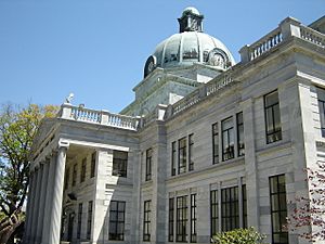
Montgomery County Courthouse in Norristown, May 2007
|
|||
|
|||
| Nickname(s):
Montco
|
|||
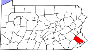
Location within the U.S. state of Pennsylvania
|
|||
 Pennsylvania's location within the U.S. |
|||
| Country | |||
| State | |||
| Founded | September 10, 1784 | ||
| Named for | Richard Montgomery or Montgomeryshire | ||
| Seat | Norristown | ||
| Largest municipality | Lower Merion Township | ||
| Area | |||
| • Total | 487 sq mi (1,260 km2) | ||
| • Land | 483 sq mi (1,250 km2) | ||
| • Water | 4.2 sq mi (11 km2) 0.9% | ||
| Population
(2020)
|
|||
| • Total | 856,553 | ||
| • Estimate
(2022)
|
868,742 |
||
| • Density | 1,773/sq mi (685/km2) | ||
| Time zone | UTC−5 (Eastern) | ||
| • Summer (DST) | UTC−4 (EDT) | ||
| Congressional districts | 1st, 4th, 5th | ||
Montgomery County, often called Montco, is a county in Pennsylvania. In 2020, about 856,553 people lived here. This makes it the third-most populated county in Pennsylvania. Only Philadelphia and Allegheny counties have more people. It is also the most populated county in Pennsylvania without a major city. Montco is part of the Delaware Valley region in the southeastern part of the state.
Norristown is the county seat and the largest city in Montgomery County. The county is part of a big metropolitan area. This area includes Philadelphia, Camden, and Wilmington. It is known as the Delaware Valley. Montgomery County marks the northern edge of this valley.
The county shares borders with several other counties. To the southeast is Philadelphia, a very large city. Bucks County is to the east. Berks and Lehigh counties are to the north. Delaware County is to the south. Chester County is to the southwest.
Montgomery County was created on September 10, 1784. It was formed from land that was originally part of Philadelphia County. The first courthouse was in the Barley Sheaf Inn. The county's name might come from Richard Montgomery. He was an American Revolutionary War general who died in 1775. Another idea is that it was named after Montgomeryshire, a county in Wales. This Welsh county was named after Roger de Montgomerie, a helper of William the Conqueror. Many Quakers from Wales settled in this area, which was called the Welsh Tract.
Contents
Exploring Montgomery County's Geography
According to the U.S. Census Bureau, Montgomery County covers about 487 square miles. Most of this area, 483 square miles, is land. The remaining 4.2 square miles, or 0.9%, is water.
Neighboring Counties
Montgomery County is surrounded by other counties.
- Lehigh County (north)
- Bucks County (northeast)
- Philadelphia County (southeast)
- Delaware County (southwest)
- Chester County (west)
- Berks County (northwest)
Special Protected Areas
Part of the famous Valley Forge National Historical Park is located in Montgomery County. This park is important for American history.
County Parks to Visit
Montgomery County has many parks for everyone to enjoy.
| Park | Size (Acres) | Trail Miles |
|---|---|---|
| Perkiomen Valley Park | 800 | 19 |
| Green Lane Park | 3,400 | 25 |
| Schuylkill Canal Park | - | 5 |
| Lorimer Park | 230 | 5.4 |
| Lower Perkiomen Valley Park | 107 | - |
| Norristown Farm Park | 690 | 8 |
| Upper Schuylkill Valley Park | 15 | - |
People and Population in Montco
Montgomery County has grown a lot over the years.
| Historical population | |||
|---|---|---|---|
| Census | Pop. | %± | |
| 1790 | 22,918 | — | |
| 1800 | 24,150 | 5.4% | |
| 1810 | 29,703 | 23.0% | |
| 1820 | 35,793 | 20.5% | |
| 1830 | 39,406 | 10.1% | |
| 1840 | 47,241 | 19.9% | |
| 1850 | 58,291 | 23.4% | |
| 1860 | 70,500 | 20.9% | |
| 1870 | 81,612 | 15.8% | |
| 1880 | 96,494 | 18.2% | |
| 1890 | 123,290 | 27.8% | |
| 1900 | 138,995 | 12.7% | |
| 1910 | 169,590 | 22.0% | |
| 1920 | 199,310 | 17.5% | |
| 1930 | 265,804 | 33.4% | |
| 1940 | 289,247 | 8.8% | |
| 1950 | 353,068 | 22.1% | |
| 1960 | 516,682 | 46.3% | |
| 1970 | 623,799 | 20.7% | |
| 1980 | 643,621 | 3.2% | |
| 1990 | 678,111 | 5.4% | |
| 2000 | 750,097 | 10.6% | |
| 2010 | 799,884 | 6.6% | |
| 2020 | 856,553 | 7.1% | |
| 2022 (est.) | 864,683 | 8.1% | |
| U.S. Decennial Census 1790–1960 1900–1990 1990–2000 2010–2020 |
|||
Who Lives in Montgomery County?
The 2020 census showed the different groups of people living in the county. About 73.27% of the county's population was White. About 9.55% were Black or African American. Around 7.94% were Asian. People of two or more races made up 6.13%. About 6.36% of the population was Hispanic or Latino.
| Race | Number of People | Percentage |
|---|---|---|
| White (not Hispanic) | 618,244 | 72.2% |
| Black or African American (not Hispanic) | 79,510 | 9.3% |
| Native American (not Hispanic) | 763 | 0.1% |
| Asian (not Hispanic) | 67,761 | 8% |
| Pacific Islander (not Hispanic) | 168 | 0.02% |
| Other/Mixed (not Hispanic) | 35,595 | 4.2% |
| Hispanic or Latino | 54,512 | 6.4% |
Largest Towns and Townships
Here are some of the biggest communities in Montgomery County by population:
| Township/Borough | Population (2010 US Census) | Density mi2 |
|---|---|---|
| Lower Merion Township | 57,825 | 2,526.1 |
| Abington Township | 55,310 | 3,630.3 |
| Cheltenham Township | 36,793 | 4,083.1 |
| Municipality of Norristown | 34,324 | 9,806.9 |
| Upper Merion Township | 28,395 | 1,593.3 |
| Horsham Township | 26,147 | 1,398.6 |
| Upper Dublin Township | 25,569 | 1,960.7 |
| Lower Providence Township | 25,436 | 1,458.8 |
| Montgomery Township | 24,790 | 2,067.1 |
| Upper Moreland Township | 24,015 | 3,202 |
Economy and Jobs in Montgomery County
Montgomery County is a suburb of Philadelphia, a very large city. Many people who live in Montco work in Philadelphia. But the county also has many jobs of its own. Big business parks are in places like Blue Bell, Lansdale, and King of Prussia. These parks bring thousands of workers from all over the region. Because there are so many jobs and taxes from them, Montgomery County has a very high credit rating. This means it is very good at managing its money.
Major Employers in the County
Many large companies and organizations have offices or facilities in Montgomery County.
- Abington School District
- ABM Industries
- ACTS Retirement-Life Communities
- Aetna
- Arcadia University
- Giant
- GlaxoSmithKline
- Hatfield Quality Meats
- Hatboro-Horsham School District
- Holy Redeemer Health System
- Janssen
- Jefferson Abington Hospital
- Lockheed Martin
- Lower Merion School District
- King of Prussia mall
- Main Line Health
- McNeil Consumer Healthcare
- Merck
- Montgomery County Community College
- Motorola Mobility
- Norristown Area School District
- North Penn School District
- Pfizer
- Prudential
- Quaker Chemical Corporation
- Quest Diagnostics
- SEI Investments Company
- Souderton Area School District
- Spring-Ford Area School District
Education in Montgomery County
The county offers many choices for learning, from colleges to public and private schools.
Colleges and Universities
Many colleges and universities are located in Montgomery County.
- Arcadia University
- Bryn Athyn College
- Bryn Mawr College
- DeVry University – Fort Washington
- Gwynedd Mercy University
- Haverford College
- Manor College
- Montgomery County Community College
- Pennsylvania College of Optometry (Salus University)
- Penn State Abington – part of Pennsylvania State University
- Reconstructionist Rabbinical College
- Rosemont College
- St. Charles Borromeo Seminary
- Saint Joseph's University
- Temple University – Ambler
- Ursinus College
- Westminster Theological Seminary
Public School Districts
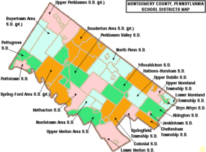
Here are the public school districts that serve students in Montgomery County:
- Abington School District
- Boyertown Area School District
- Cheltenham Township School District
- Colonial School District
- Hatboro-Horsham School District
- Jenkintown School District
- Lower Merion School District
- Lower Moreland Township School District
- Methacton School District
- Norristown Area School District
- North Penn School District
- Perkiomen Valley School District
- Pottsgrove School District
- Pottstown School District
- Souderton Area School District
Springfield Township School District
- Spring-Ford Area School District
- Upper Dublin School District
- Upper Merion Area School District
- Upper Moreland School District
- Upper Perkiomen School District
- Wissahickon School District
- Bryn Athyn School District – This district exists but does not run its own schools. Students go to schools in nearby districts.
Private Secondary Schools
Many private high schools are also in Montgomery County.
- Academy Of The New Church Boys School
- Academy Of The New Church Girls School
- Abington Friends School
- The Baldwin School
- AIM Academy
- Jack M. Barrack Hebrew Academy
- Calvary Baptist School
- Coventry Christian Schools
- Dock Mennonite Academy
- Friends' Central School
- Germantown Academy
- Gwynedd Mercy Academy High School
- Haverford School
- The Hill School
- Huntingdon Valley Christian Academy
- Indian Creek Mennonite School
- Lakeside School
- Lansdale Catholic High School
- La Salle College High School
- Lincoln Academy
- Main Line Academy
- Martin Luther School
- Mary, Mother of the Redeemer Catholic School
- Meadowbrook School
- Merion Mercy Academy
- Mount Saint Joseph Academy
- New Life Youth and Family Services
- The Pathway School
- The Perkiomen School
- Phil-Mont Christian Academy
- Pope John Paul II Catholic High School
- Reformation Christian School
- Saint Aloysius School
- Saint Katherine Day School
- Stowe Lighthouse Christ Academy
- The Shipley School
- Torah Academy of Greater Philadelphia
- Trinity Christian Academy
- Valley Christian School at Huntingdon Valley Presbyterian Church
- Valley Forge Baptist Academy
- Wordsworth Academy
- Wyncote Academy
Night Schools and Adult Education
- Abington Township Adult School
- Cheltenham Township Adult School
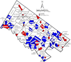
Communities in Montgomery County
Pennsylvania law lists different types of towns and cities. These include cities, boroughs, townships, and home rule municipalities. Here are the communities in Montgomery County:
Home Rule Municipalities
These communities have special local rules.
- Bryn Athyn
- Cheltenham Township
- Horsham Township
- Norristown (the county seat)
- Plymouth Township
- Whitemarsh Township
Boroughs
Boroughs are a type of self-governing community.
Townships
Townships are another type of local government area.
- Abington
- Cheltenham
- Douglass
- East Norriton
- Franconia
- Hatfield
- Horsham
- Limerick
- Lower Frederick
- Lower Gwynedd
- Lower Merion
- Lower Moreland
- Lower Pottsgrove
- Lower Providence
- Lower Salford
- Marlborough
- Montgomery
- New Hanover
- Perkiomen
- Plymouth
- Salford
- Skippack
- Springfield
- Towamencin
- Upper Dublin
- Upper Frederick
- Upper Gwynedd
- Upper Hanover
- Upper Merion
- Upper Moreland
- Upper Pottsgrove
- Upper Providence
- Upper Salford
- West Norriton
- West Pottsgrove
- Whitemarsh
- Whitpain
- Worcester
Unincorporated Areas
These areas are not officially separate towns or cities, but they are recognized for census data.
Census-Designated Places (CDPs)
- Arcadia University
- Ardmore
- Audubon
- Bala Cynwyd
- Blue Bell
- Bryn Mawr
- Cheltenham (Cheltenham Village)
- Eagleville
- Elkins Park
- Evansburg
- Flourtown
- Fort Washington
- Gilbertsville
- Glenside
- Halfway House
- Harleysville
- Haverford College
- Horsham
- King of Prussia
- Kulpsville
- McKinley
- Maple Glen
- Merion Station
- Mont Clare
- Montgomeryville
- Oreland
- Penn Wynne
- Plymouth Meeting
- Pottsgrove
- Rosemont
- Roslyn
- Sanatoga
- Skippack
- Spring House
- Spring Mount
- Stowe
- Swedeland
- Trooper
- Villanova (partly in Delaware County)
- Willow Grove
- Woxall
- Wyncote
- Wyndmoor
Other Communities
These are other smaller communities or villages.
- Ardsley
- Bethayres
- Dresher
- Frederick
- Graterford
- Gladwyne
- Gwynedd
- Gwynedd Valley
- Huntingdon Valley (small sections in Bucks County)
- Lafayette Hill
- Lederach
- Linfield
- Meadowbrook
- Melrose Park
- Oaks
- Port Providence
- Wynnewood (partly in Delaware County)
The historic village of Valley Forge and its park are partly in Montgomery County. However, the modern village is in Chester County, PA.
Population Ranking of Communities
This table shows the population of the largest communities based on the 2020 census. † county seat
| Rank | City/Town/etc. | Municipal type | Population (2020 Census) |
|---|---|---|---|
| 1 | † Norristown | Municipality | 35,748 |
| 2 | Pottstown | Borough | 23,433 |
| 3 | King of Prussia | CDP | 22,028 |
| 4 | Lansdale | Borough | 18,773 |
| 5 | Horsham | CDP | 15,193 |
| 6 | Willow Grove | CDP | 13,730 |
| 7 | Ardmore (partially in Delaware County) | CDP | 13,566 |
| 8 | Montgomeryville | CDP | 12,998 |
| 9 | Harleysville | CDP | 9,899 |
| 10 | Conshohocken | Borough | 9,261 |
| 11 | Audubon | CDP | 8,688 |
| 12 | Sanatoga | CDP | 8,496 |
| 13 | Hatboro | Borough | 8,238 |
| 14 | Kulpsville | CDP | 8,159 |
| 15 | Glenside | CDP | 7,737 |
| 16 | Plymouth Meeting | CDP | 7,452 |
| 17 | Souderton | Borough | 7,191 |
| 18 | Ambler | Borough | 6,807 |
| 19 | Maple Glen | CDP | 6,647 |
| 20 | Blue Bell | CDP | 6,506 |
| 21 | Penn Wynne | CDP | 6,493 |
| 22 | Oreland | CDP | 6,210 |
| 23 | Fort Washington | CDP | 5,910 |
| 24 | Bryn Mawr | CDP | 5,879 |
| 25 | Wyndmoor | CDP | 5,853 |
| 26 | Gilbertsville | CDP | 5,508 |
| 27 | Trooper | CDP | 5,481 |
| 28 | Collegeville | Borough | 5,043 |
| 29 | Bridgeport | Borough | 5,015 |
| 30 | Royersford | Borough | 4,940 |
| 31 | Telford (partially in Bucks County) | Borough | 4,928 |
| 32 | Eagleville | CDP | 4,800 |
| 33 | Flourtown | CDP | 4,786 |
| 34 | Jenkintown | Borough | 4,719 |
| 35 | Narberth | Borough | 4,492 |
| 36 | Gladwyne | CDP | 4,096 |
| 37 | Trappe | Borough | 4,002 |
| 38 | Pennsburg | Borough | 3,889 |
| 39 | Spring House | CDP | 3,978 |
| 40 | Skippack | CDP | 3,928 |
| 41 | Stowe | CDP | 3,697 |
| 42 | Hatfield | Borough | 3,496 |
| 43 | Pottsgrove | CDP | 3,471 |
| 44 | North Wales | Borough | 3,426 |
| 45 | Halfway House | CDP | 3,273 |
| 46 | East Greenville | Borough | 3,166 |
| 47 | Wyncote | CDP | 3,081 |
| 48 | Rockledge | Borough | 2,638 |
| 49 | Spring Mount | CDP | 2,498 |
| 50 | Red Hill | Borough | 2,496 |
| 51 | Evansburg | CDP | 2,410 |
| 52 | Haverford College (mostly in Delaware County) | CDP | 1,497 |
| 53 | West Conshohocken | Borough | 1,493 |
| 54 | Woxhall | CDP | 1,297 |
| 55 | Schwenksville | Borough | 1,296 |
| 56 | Bryn Athyn | Municipality | 1,272 |
| 57 | Arcadia University | CDP | 758 |
| 58 | Green Lane | Borough | 490 |
Getting Around Montgomery County
There are many ways to travel in and out of Montgomery County.
Major Roads and Highways

Important roads that cross the county include:
 I-76
I-76
 I-276 / Penna Turnpike
 I-476 / Penna Turnpike NE Extension
 US 1
US 1 US 30
US 30 US 202


 US 202 Bus.
 US 422
 PA 23
PA 23 PA 29
PA 29 PA 63
PA 63 PA 73
PA 73 PA 100
 PA 113
 PA 152
 PA 232
 PA 252
 PA 263
 PA 309
 PA 320
 PA 332
 PA 363
 PA 463
 PA 563
 PA 611
 PA 663
Public Transportation Options
The SEPTA system provides public transport in the county. This includes buses, commuter trains, and light rail. Pottstown Area Rapid Transit (PART) also offers bus services around the Pottstown area.
- SEPTA services include:
- Buses that serve both city and suburban areas.
- Regional Rail lines like Cynwyd, Lansdale/Doylestown, and Manayunk/Norristown.
- The Norristown High Speed Line (NHSL), a light rail line. It connects the Norristown Transportation Center to Upper Darby in Delaware County.
Airports in the Area
Most people flying to or from the area use Philadelphia International Airport. This is one of the largest airports in the country. It is located in Philadelphia and Delaware counties.
Other smaller public airports in Montgomery County include Heritage Field in Limerick Township. There is also Wings Field in Blue Bell. And Pottstown Municipal Airport is in Pottstown.
Culture and Community Life
Montgomery County is home to interesting cultural organizations.
- The Institutes for the Achievement of Human Potential (IAHP) is in Wyndmoor. It started in 1955. This group teaches parents about how children's brains develop. It also helps children with brain injuries.
- The Old York Road Symphony is based in Abington. It is one of the oldest orchestras in the country where all the musicians are volunteers. It was founded in 1932.
Climate in Montgomery County
Most of Montgomery County has a hot-summer humid continental climate. This means it has warm summers and cold winters. Some southern areas and along the Schuylkill River have a humid subtropical climate. This climate is a bit warmer and more humid.
| Climate data for Upper Hanover Twp (Elevation: 489 ft; 149 m) 1981 - 2010 Averages | |||||||||||||
|---|---|---|---|---|---|---|---|---|---|---|---|---|---|
| Month | Jan | Feb | Mar | Apr | May | Jun | Jul | Aug | Sep | Oct | Nov | Dec | Year |
| Mean daily maximum °F (°C) | 37.8 (3.2) |
41.1 (5.1) |
49.8 (9.9) |
61.7 (16.5) |
72.1 (22.3) |
80.8 (27.1) |
84.9 (29.4) |
83.2 (28.4) |
76.2 (24.6) |
64.5 (18.1) |
53.3 (11.8) |
41.8 (5.4) |
62.4 (16.9) |
| Daily mean °F (°C) | 29.3 (−1.5) |
31.9 (−0.1) |
39.7 (4.3) |
50.5 (10.3) |
60.4 (15.8) |
69.5 (20.8) |
74.0 (23.3) |
72.3 (22.4) |
64.8 (18.2) |
53.2 (11.8) |
43.5 (6.4) |
33.5 (0.8) |
52.0 (11.1) |
| Mean daily minimum °F (°C) | 20.8 (−6.2) |
22.7 (−5.2) |
29.6 (−1.3) |
39.2 (4.0) |
48.7 (9.3) |
58.3 (14.6) |
63.0 (17.2) |
61.4 (16.3) |
53.4 (11.9) |
41.9 (5.5) |
33.7 (0.9) |
25.2 (−3.8) |
41.6 (5.3) |
| Average precipitation inches (mm) | 3.27 (83) |
2.71 (69) |
3.55 (90) |
3.86 (98) |
4.27 (108) |
4.21 (107) |
4.83 (123) |
3.90 (99) |
4.63 (118) |
4.26 (108) |
3.65 (93) |
3.75 (95) |
46.89 (1,191) |
| Average relative humidity (%) | 68.4 | 65.1 | 60.6 | 59.5 | 63.6 | 69.0 | 69.0 | 71.8 | 72.9 | 71.4 | 70.4 | 70.7 | 67.7 |
| Average dew point °F (°C) | 20.2 (−6.6) |
21.5 (−5.8) |
27.2 (−2.7) |
36.9 (2.7) |
48.0 (8.9) |
58.9 (14.9) |
63.2 (17.3) |
62.7 (17.1) |
55.9 (13.3) |
44.2 (6.8) |
34.5 (1.4) |
25.0 (−3.9) |
41.6 (5.3) |
| Source: PRISM | |||||||||||||
| Climate data for Cheltenham (Elevation: 125 ft; 38 m) 1981 - 2010 Averages | |||||||||||||
|---|---|---|---|---|---|---|---|---|---|---|---|---|---|
| Month | Jan | Feb | Mar | Apr | May | Jun | Jul | Aug | Sep | Oct | Nov | Dec | Year |
| Mean daily maximum °F (°C) | 40.6 (4.8) |
43.9 (6.6) |
52.0 (11.1) |
63.3 (17.4) |
73.0 (22.8) |
82.3 (27.9) |
86.3 (30.2) |
84.9 (29.4) |
78.0 (25.6) |
66.7 (19.3) |
55.9 (13.3) |
44.9 (7.2) |
64.4 (18.0) |
| Daily mean °F (°C) | 33.2 (0.7) |
35.9 (2.2) |
43.2 (6.2) |
53.7 (12.1) |
63.2 (17.3) |
72.8 (22.7) |
77.3 (25.2) |
76.0 (24.4) |
68.8 (20.4) |
57.3 (14.1) |
47.5 (8.6) |
37.7 (3.2) |
55.6 (13.1) |
| Mean daily minimum °F (°C) | 25.8 (−3.4) |
27.8 (−2.3) |
34.3 (1.3) |
44.0 (6.7) |
53.4 (11.9) |
63.2 (17.3) |
68.4 (20.2) |
67.1 (19.5) |
59.6 (15.3) |
48.0 (8.9) |
39.2 (4.0) |
30.4 (−0.9) |
46.9 (8.3) |
| Average precipitation inches (mm) | 3.46 (88) |
2.77 (70) |
4.10 (104) |
3.92 (100) |
4.15 (105) |
4.12 (105) |
4.96 (126) |
4.24 (108) |
4.29 (109) |
3.71 (94) |
3.52 (89) |
3.92 (100) |
47.16 (1,198) |
| Average relative humidity (%) | 65.5 | 61.6 | 57.3 | 57.2 | 61.4 | 63.5 | 65.0 | 66.9 | 68.0 | 67.9 | 66.5 | 66.6 | 64.0 |
| Average dew point °F (°C) | 22.9 (−5.1) |
24.0 (−4.4) |
29.1 (−1.6) |
38.9 (3.8) |
49.7 (9.8) |
59.7 (15.4) |
64.6 (18.1) |
64.2 (17.9) |
57.8 (14.3) |
46.8 (8.2) |
36.9 (2.7) |
27.6 (−2.4) |
43.6 (6.4) |
| Source: PRISM | |||||||||||||
See also
 In Spanish: Condado de Montgomery (Pensilvania) para niños
 | Shirley Ann Jackson |
 | Garett Morgan |
 | J. Ernest Wilkins Jr. |
 | Elijah McCoy |


