
Whitemarsh Township, Pennsylvania facts for kids
Quick facts for kids
Whitemarsh Township
|
|||||
|---|---|---|---|---|---|
|
Home rule municipality
|
|||||

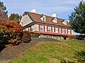
Farmar Mill in Whitemarsh Township, built c. 1690
|
|||||
|
|||||

Location of Whitemarsh Township in Montgomery County, Pennsylvania
|
|||||
| Country | United States | ||||
| State | Pennsylvania | ||||
| County | Montgomery | ||||
| Settled | 1683 | ||||
| Area | |||||
| • Total | 14.73 sq mi (38.2 km2) | ||||
| • Land | 14.59 sq mi (37.8 km2) | ||||
| • Water | 0.14 sq mi (0.4 km2) | ||||
| Elevation | 220 ft (70 m) | ||||
| Population
(2010)
|
|||||
| • Total | 17,349 | ||||
| • Estimate
(2016)
|
17,795 | ||||
| • Density | 1,177.8/sq mi (454.75/km2) | ||||
| Time zone | UTC-5 (EST) | ||||
| • Summer (DST) | UTC-4 (EDT) | ||||
| Area code(s) | 610, 484 | ||||
| FIPS code | 42-091-84624 | ||||


Whitemarsh Township is a special kind of town in Montgomery County, Pennsylvania, United States. It's called a "home rule municipality," which means it has its own rules, but it still uses the name "Township." In 2020, about 19,707 people lived there.
Whitemarsh is next to the Roxborough area of Philadelphia. It shares borders with other towns in Montgomery County like Springfield, Upper Dublin, Whitpain, and Plymouth. The Schuylkill River also runs along its edge, separating it from Lower Merion Township.
Some smaller communities within Whitemarsh Township include Barren Hill, Lafayette Hill, and parts of Miquon, Spring Mill, Plymouth Meeting, and Fort Washington.
Contents
History of Whitemarsh Township
Whitemarsh was first home to the Lenape tribe of Native Americans. European settlers arrived in 1683. This land was part of a large area bought by Major Jasper Farmar from William Penn.
Major Farmar passed away before he could move there. But his family, including his wife and servants, sailed to Philadelphia in 1685. They set up their home in nearby Fort Washington. After Farmar's wife died in the 1690s, her son Edward started selling smaller pieces of their Whitemarsh land. He sold 100 to 200-acre plots to Quakers and German immigrants.
Early Discoveries and Growth
In 1686, a valuable rock called limestone was found in Oreland. This area is close to Whitemarsh. When limestone was later found in Whitemarsh itself, more people moved to the township.
In 1704, Whitemarsh Township officially became a town. At first, it was part of Philadelphia County. Then, in 1784, Montgomery County was created. Whitemarsh became one of the first 28 communities in this new county. For many years, Whitemarsh was known for its large English estates and its famous limestone quarries.
Whitemarsh During the American Revolution
During the American Revolutionary War, two important battles happened in Whitemarsh. These were the Battle of White Marsh and the Battle of Barren Hill. These events are a big part of the township's history.
Historic Places to Explore
Many buildings and areas in Whitemarsh Township are very old and important. They are listed on the National Register of Historic Places. This means they are protected because of their history. Some of these places include:
- Alan West Corson Homestead
- Cold Point Historic District
- County Bridge No. 54
- Farmar Mill
- Hope Lodge
- Hovenden House, Barn and Abolition Hall
- Lee Tire and Rubber Company
- Miller's House at Spring Mill
- Mount Joy
- Plymouth Meeting Historic District
- The Highlands
- Union School
Geography of Whitemarsh
Whitemarsh Township covers about 14.7 square miles (38.1 square kilometers). Most of this area, about 14.6 square miles (37.8 square kilometers), is land. A small part, about 0.1 square miles (0.3 square kilometers), is water.
The U.S. Census Bureau has identified two special areas that include parts of Whitemarsh. These are Plymouth Meeting and Fort Washington.
Population and People
| Historical population | |||
|---|---|---|---|
| Census | Pop. | %± | |
| 1850 | 2,408 | — | |
| 1860 | 3,047 | 26.5% | |
| 1870 | 3,151 | 3.4% | |
| 1880 | 3,239 | 2.8% | |
| 1890 | 3,516 | 8.6% | |
| 1900 | 3,350 | −4.7% | |
| 1910 | 3,359 | 0.3% | |
| 1920 | 3,436 | 2.3% | |
| 1930 | 4,286 | 24.7% | |
| 1940 | 4,855 | 13.3% | |
| 1950 | 5,977 | 23.1% | |
| 1960 | 12,286 | 105.6% | |
| 1970 | 15,886 | 29.3% | |
| 1980 | 14,987 | −5.7% | |
| 1990 | 14,863 | −0.8% | |
| 2000 | 16,702 | 12.4% | |
| 2010 | 17,349 | 3.9% | |
| 2020 | 19,707 | 13.6% | |
| Population 1850-2010 | |||
In 2010, most people in Whitemarsh Township were White (90.7%). There were also Black or African American (3.5%), Asian (4.2%), and people of two or more races (1.2%). About 1.7% of the population had Hispanic or Latino family backgrounds.
In 2000, there were 16,702 people living in the township. There were 6,179 households, and 4,597 of these were families. The average household had about 2.62 people, and the average family had about 3.06 people.
About 24.3% of the people were under 18 years old. The median age was 40 years. This means half the people were younger than 40 and half were older.
Fun and Recreation
Whitemarsh Township has many places for fun and outdoor activities.
Parks and Green Spaces
Fort Washington State Park is a large park in the middle of the township. It covers about 483 acres (1.95 square kilometers) and is located along the Wissahickon Creek. It's a great place to explore nature.
Miles Park is another popular spot. It has basketball courts and baseball fields. There's also a walking track, a snack bar, and vending machines for visitors.
Country Clubs and Golf
Several country clubs are located in Whitemarsh Township. These include the Whitemarsh Valley Country Club, the ACE Club, and the Green Valley Club. Each of these has its own golf course. The Philadelphia Cricket Club is also here, and it has two golf courses!
Education for Kids
The Colonial School District is responsible for public education in Whitemarsh Township. This district provides schools for children living in the area.
Getting Around Whitemarsh
Whitemarsh Township has many roads and ways to travel.
Major Roads and Highways
The Pennsylvania Turnpike (Interstate 276) runs east-west through the township. The Fort Washington Expressway (Pennsylvania Route 309) runs north-south. While these major highways don't have exits directly in Whitemarsh, you can find nearby exits in Plymouth Township and Fort Washington.
Other important roads in the township include Ridge Pike, Germantown Pike, Butler Pike, Skippack Pike (Pennsylvania Route 73), Bethlehem Pike, Stenton Avenue, Pennsylvania Avenue, Joshua Road, and Morris Road.
Train and Bus Services
Two SEPTA Regional Rail train lines serve Whitemarsh Township. The Lansdale/Doylestown Line has a station called Fort Washington station on the eastern side of the township. The Manayunk/Norristown Line runs along the Schuylkill River and has two stations in the western part of the township: Miquon and Spring Mill.
SEPTA also runs several bus routes in Whitemarsh. These include City Bus Routes 27 and L, and Suburban Bus Routes 94, 95, 97, and 201. These buses connect the township to Philadelphia and other nearby towns.
Since 2017, OurBus has offered intercity bus service from Whitemarsh Township. You can catch a bus from the Fort Washington railroad station to places like West Chester, Pennsylvania, and even New York City.
Freight Trains and Airports
The Norfolk Southern Railway's Morrisville Line carries only freight (goods, not people) through Whitemarsh Township. It runs next to the Pennsylvania Turnpike.
There are no airports directly in Whitemarsh Township. The closest airport is Wings Field in nearby Whitpain Township.
Images for kids
-
Mount Joy, built 1735
-
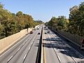
I-276/Pennsylvania Turnpike eastbound in Whitemarsh Township

_from_the_overpass_for_Joshua_Road_in_Whitemarsh_Township,_Montgomery_County,_Pennsylvania.jpg)
See also
 In Spanish: Municipio de Whitemarsh para niños
