Roxborough, Philadelphia facts for kids
Quick facts for kids
Roxborough
|
|
|---|---|
|
Neighborhood
|
|
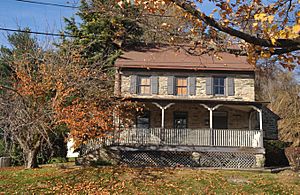
Miquon House
Motto: "A Place With Roots" |
|
| Country | |
| State | Pennsylvania |
| County | Philadelphia |
| City | Philadelphia |
| Population | 30,940 |
| ZIP Code |
19128
|
| Area code(s) | 215, 267 and 445 |
Roxborough is a neighborhood in Northwest Philadelphia, Pennsylvania, United States. It's located next to the Schuylkill River on one side and Fairmount Park on another. To the southeast, you'll find East Falls, and to the northwest is Montgomery County. Roxborough's ZIP Code is 19128, and most of it is in Philadelphia's 21st Ward.
Contents
History of Roxborough
|
Roxborough Township
|
|
|---|---|
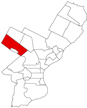
Map of Philadelphia County, Pennsylvania highlighting Roxborough Township prior to the Act of Consolidation, 1854
|
Long ago, a Native American path called the Manatawny ran through this area. This path is now Ridge Avenue. In 1690, the path was renamed Ridge Road because it follows the top of a hill between two valleys. The area itself was first called Roxburgh. It was probably named after Roxburghshire, Scotland, which was the home of Andrew Robeson, an early settler. By 1707, the name changed to Roxborough.
Most of Roxborough used to be part of Roxborough Township. In 1854, this township became part of the City of Philadelphia. At that time, many wealthy people lived in Roxborough. They owned the textile mills in nearby Manayunk. The money from these mills helped build schools, parks, and even a large home for elderly women called The Roxborough Home for Women.
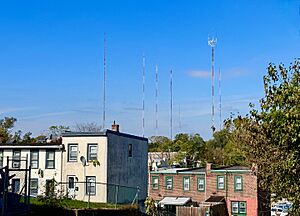
Since the 1950s, many major TV and FM radio stations have placed their tall towers in Roxborough. This is because the area has high hills, which helps broadcast signals far away. The tallest tower, the American Tower, is about 1,250 feet (381 meters) high!
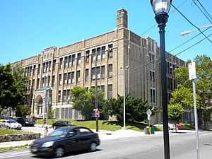
Two important places, the Upper Roxborough Historic District and William Levering School, are listed on the National Register of Historic Places. This means they are special historical sites.
Geography and Nature
Roxborough is well-connected to Center City Philadelphia. You can get there using many bus routes and bike lanes. The SEPTA Regional Rail line also stops at the Ivy Ridge station in Roxborough, as well as in Manayunk and Wissahickon.
Two universities, Philadelphia University and St. Joseph's University, are also nearby.
Henry Avenue runs next to Ridge Avenue. It was built in the 1930s and extended in 1959. It has several cool concrete bridges, like the Wissahickon Memorial Bridge. This bridge even has tunnels underneath that were meant for a subway line that was never built!
Roxborough and Manayunk are separated from the rest of the city by the Wissahickon Creek and its park. Lower Roxborough has many "row homes" and older houses from the 1800s and early 1900s, giving it a historic city feel.
The Wissahickon Valley Park is part of the Fairmount Park system. It has many trails that people use for biking, running, walking dogs, and mountain biking.
The northwest part of Roxborough is often called Upper Roxborough. This area developed after 1950 and feels more like a suburb. It has bigger yards, garages, and shopping centers.
How Roxborough Got Its Name
Andrew Robeson and Roxburgh, Scotland
Roxborough was likely named after Roxburghshire, Scotland. This was the original home of Andrew Robeson, who was one of the first settlers in the area.
In 1676, Andrew Robeson came to America from Scotland. He became a very important person, helping to map out land in New Jersey and serving as a judge. In 1690, he moved to Philadelphia and bought land in what is now Roxborough.
His nephew, Andrew Jr., was also important. He was the Chief Justice in Pennsylvania from 1693 to 1699. He was responsible for making Roxborough a township in 1690. The Robeson family came from a town called Kelso in Roxburghshire, Scotland.
Rocksburrow and Foxes
In 1706, a German philosopher named Johannes Kelpius lived in the woods near the Robeson family. He wrote about "foxes burrowing in rocks" in the area. Many German residents started calling the township "Rocksburrow" because it sounded like what Kelpius described.
Kelpius's writings made this spelling popular. Even though the spelling later changed to Roxborough, many people believed the name came from the idea of foxes burrowing in rocks. Other old writings also spelled the name as Roxbury and Roxboro.
Education in Roxborough
Schools for Kids
The School District of Philadelphia runs the public schools here. Some of the schools for this area include Shawmont Elementary, Cook Wissahickon, and Roxborough High School.
There are also special high schools in upper Roxborough: the Walter Biddle Saul High School of Agricultural Sciences and Lankenau Environmental Magnet High School.
The William Levering School, which started in 1748, closed in 2012. Now, the Academy for the Middle Years (AMY) Northwest Middle School, a special middle school for grades 6-8, uses that building.
Many students from Roxborough also attend Roman Catholic and J.W. Hallahan High Schools.
Public Libraries
The Free Library of Philadelphia has a branch in Roxborough at 6245 Ridge Avenue. This library also has a special room for historical records about Roxborough, Manayunk, Wissahickon, East Falls, and Andorra.
Parks and Fun Places
Roxborough has many great places to enjoy the outdoors and have fun:
- Wissahickon Valley Park
- Courtesy Stable (in Wissahickon Valley Park)
- Gorgas Park
- Kendrick Recreation Center
- Roxborough Pocket Park
- Schuylkill Center for Environmental Education
- Walnut Lane Golf Course
- Upper Roxborough Reservoir Preserve
- Al Pearlman Sports Complex
- Kelly Park
- Roxborough YMCA
- Houston Playground (Philadelphia Parks & Recreation)
Getting Around Roxborough
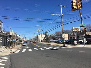
One of the oldest and most important roads in Roxborough is Ridge Avenue. It used to be a Native American path called the Manatawny. By the 1700s, it was known as "The Great Road from Philadelphia to Reading." Stagecoaches used to travel on it often, and many inns were built along the way. Ridge Road was even used by soldiers during the American Revolution in 1777!
Another main road is Henry Avenue. It was built in the late 1950s and runs parallel to Ridge Avenue.
The SEPTA Regional Rail line connects Roxborough to Center City. It stops at the Ivy Ridge station, Manayunk station, and Wissahickon station. The historic Shawmont station closed in 1996.
You can also get around Roxborough using SEPTA bus routes 1, 9, 27, 32, 35, and 65.
Cool Places to See
Here are some interesting spots in Roxborough:
- Dalessandro's Steaks, a famous place to get a cheesesteak
- Church of St. Alban, Roxborough Episcopal church
- Leverington Cemetery, a very old cemetery started in 1745
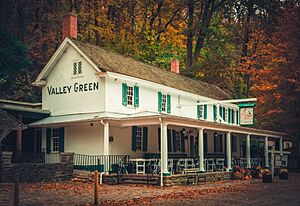
- Valley Green Inn, the last remaining old "roadhouse" in Philadelphia
 | Chris Smalls |
 | Fred Hampton |
 | Ralph Abernathy |


