
Wissahickon Creek facts for kids
Quick facts for kids Wissahickon Creek |
|
|---|---|

Wissahickon Creek runs through Fort Washington State Park
|
|

Schuylkill River watershed
|
|
| Country | USA |
| State | Pennsylvania |
| Region | Montgomery County, Philadelphia County |
| Physical characteristics | |
| Main source | 40°14′34″N 75°15′16″W / 40.24278°N 75.25444°W |
| River mouth | 40°0′47″N 75°12′25″W / 40.01306°N 75.20694°W |
| Length | 23 mi (37 km) |
| Basin features | |
| Basin size | 64 sq mi (170 km2) |
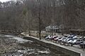
The Wissahickon Creek is a beautiful stream in Pennsylvania, USA. It flows for about 23 miles (37 km) through Montgomery and Philadelphia Counties. This creek is a tributary, meaning it's a smaller river that flows into a larger one, which in this case is the Schuylkill River. The area that drains into the Wissahickon Creek, called its watershed, is about 64 square miles (166 km²).
A large part of the creek runs through or next to parkland. The last few miles flow through a deep, rocky valley called a gorge. This beautiful area has inspired many writers, like Edgar Allan Poe. The gorge is now part of the Fairmount Park system in Philadelphia. The Wissahickon Valley is so special that it's recognized as one of 600 National Natural Landmarks in the United States.
The name "Wissahickon" comes from the Lenape language. The Lenape people were Native Americans who lived in this area. The word wiessahitkonk means "catfish creek" or "stream of yellowish color." On one of the earliest maps of Pennsylvania, made by Thomas Holme, the creek was called Whitpaine's creek. This was named after Richard Whitpaine, an early settler who owned land along the creek when William Penn founded Pennsylvania.
After Europeans settled here, industries quickly grew along the Wissahickon. America's first paper mill was even built on one of the creek's smaller streams. You can still see some of the old dams that were built for these mills today.
Contents
Exploring the Wissahickon Valley

.jpeg)

The Wissahickon Creek starts out calm, but in its last 7 miles (11 km), it drops more than 100 feet (30 m) in height. This creates a dramatic landscape with dense forests that attracts thousands of people. Visitors enjoy walking, riding horses, and biking here.
Popular Trails and Access Points
The most popular path in the lower Wissahickon valley is called Forbidden Drive. It's a gravel road that follows the creek from Lincoln Drive to the county line. It got its name in the 1920s when cars were first banned from it. You can bike or ride horses on Forbidden Drive without a special pass. Other trails in the park have more rules. Some don't allow bikes or horses, and others require a permit for them. Everyone using the park is asked to stay on marked trails to help protect the land from erosion.
There's also a paved path on the west side of the creek. It connects Forbidden Drive to Ridge Avenue, where the Wissahickon meets the Schuylkill River. This path is great for cyclists coming from other bike paths or for people arriving by train or bus at Wissahickon Station.
You can also get to Forbidden Drive in the middle at the Valley Green Inn. Valley Green Road leads there from Springfield Avenue in Chestnut Hill. Another way to reach Forbidden Drive is from Wise's Mill Road, which connects to Henry Avenue in Roxborough.
Upper Trails and Hiking Adventures
Many trails climb out of the valley from Forbidden Drive to the "upper trails." These trails run along the steep sides of the valley. Some of these upper trails are marked with different colors.
- The green blazed trail is for mountain bikers with permits.
- The blue blazed trail is only for hiking.
- All trails in the Andorra Natural Area do not allow bicycles.
- The orange trail runs along the east side of the creek. It's often steeper and rockier than other trails, and you can only use it for hiking.
Special Spots and Landmarks
Devil's Pool is a popular spot. You can reach it from Valley Green by crossing the stream and following the path downstream on the eastern bank. The water gathers in a pool surrounded by rocks before flowing into the Wissahickon Creek. It's said that the Native American Lenape tribes used this as a spiritual place. While swimming here is not allowed due to water quality, it's a popular spot to relax. People are working to keep Devil's Pool clean from litter.
Another romantic hike leads to a high point overlooking the gorge. You can find it by entering the park at the Ridge Avenue entrance and following the west bank to Hermit's Lane Bridge. From Blue Stone Bridge, follow the path on the west side to Lover's Leap.
Mom Rinker's Rock is another famous viewpoint. It's on a ridge on the eastern side of the park, near the Walnut Lane Bridge. A marble statue called "Toleration" stands here. It shows a man in simple Quaker clothes. The statue was put there by John Welsh, a landowner who later gave his land to the park.
A large 15-foot (4.5 m) white marble statue of a kneeling Lenape warrior can also be found in the park. It was sculpted in 1902 and honors the Lenape Indians who used to hunt and fish in the Wissahickon before colonists arrived.
Wissahickon Creek's Geology
The Wissahickon Creek flows through an area with many different types of rocks. It passes through regions with sandstone and shale, limestone and dolomite, and the Wissahickon Formation.
Wissahickon Schist: A Special Rock
A very unique rock found in the Wissahickon Creek valley is Wissahickon schist. This is the main type of rock found under the ground in the Philadelphia area. It's found across southeastern Pennsylvania. This rock, first studied in the Wissahickon gorge, has shiny bits of mica, small garnets, and many shades of gray, brown, tan, and blue. It's so attractive that it was often used as a building material in the 1800s and early 1900s.
How Rocks Are Formed
Besides Wissahickon schist, there are layers of quartzite in the valley. Both schist and quartzite are metamorphic rocks. This means they were formed from other rocks that changed due to heat and pressure. They started as sedimentary deposits of mud and sand that washed into an ancient sea. Over a long time, these deposits were squeezed into shale and sandstone. During periods when mountains were forming, the shale and sandstone slowly turned into the schist and quartzite we see today. In some places, the heat and pressure were so strong that the schist mixed with igneous rocks (formed from cooled magma) to create hard, banded gneiss.
Other rocks in the valley include layers of pegmatite (an igneous rock) and parts of granite plutons, which are crystals found within the schist. In a few spots near Devil's Pool, you can find a type of schist that contains the mineral talc. Talc is so soft that you can scratch it with your fingernail.
Wissahickon Creek's Tributaries

Here are some of the smaller streams that flow into the Wissahickon Creek:
- Trewellyn Creek
- Willow Run
- Prophecy Creek
- Sandy Run
- Sunny Brook
- Lorraine Run
- Arlingham Run
- Cresheim Creek
- Gorgas Run
- Carpenter's Run
- Paper Mill Run
History of Wissahickon Creek

Early Settlers and Religious Groups
In 1694, a man named Johannes Kelpius came to Philadelphia with a group of German Christians called Pietists. They wanted to live a simple, spiritual life in the Wissahickon Valley. They formed a community and were known as the Hermits or Mystics of the Wissahickon. Kelpius was a musician and writer. He often meditated by the creek, sometimes in a cave known as the Cave of Kelpius. The group lived a celibate life (meaning they did not marry) and hoped for the end of the world. Kelpius died in 1708, and the group eventually broke up.
Other religious groups also came to the Wissahickon. In 1723, the first Church of the Brethren in America baptized new members in the creek. Around 1747, a stone house was built for church retreats. This building, called The Monastery, still stands today. It reminds us of the Wissahickon's past as a quiet place for religious groups.
From Mills to Park Land

The steep slopes and gorge that made the valley a good place for religious groups also provided a strong source of energy for water mills. By 1730, eight mills were built along the creek, and by 1793, there were twenty-four. The Wissahickon Valley became an important industrial area, with more than fifty watermills by 1850. These mills made paper, cloth, gunpowder, and processed lumber and food. Small villages like Rittenhousetown grew up around the mills.
During the Revolutionary War, the rough land of the Wissahickon Valley made it hard for soldiers to move around. There are legends about an informant named Mom Rinker who supposedly dropped messages about British troops from a rock overlooking the valley. Today, there is a place called Mom Rinker's Rock in the park.
Over time, roads were built to connect the mills. In 1856, a private toll road called the Wissahickon Turnpike linked the entire valley. However, things began to change. Benjamin Franklin had once suggested that the Wissahickon be used to supply clean water to Philadelphia. To protect the water quality of the Schuylkill River from industrial pollution, the Fairmount Park Commission started buying land along the Wissahickon in 1869-1870. The mills were torn down, with the last one removed in 1884. The Wissahickon Valley slowly returned to its natural, wild state.

People also began to appreciate nature more, thanks to a movement called Romanticism. They saw the wild beauty of the Wissahickon Valley as something special. In 1924, local residents formed the "Friends of the Wissahickon," a group that still works to protect and maintain the park today.
Bridges and Modern Times
To help connect different parts of the city, several large bridges were built over the Wissahickon.
- The Walnut Lane Bridge was built in 1906. It was the world's largest poured concrete structure at the time. It connects the Roxborough and Germantown neighborhoods of Philadelphia. The bridge is 480 feet (146 m) long and its center arch is 109 feet (33 m) above the water.
- The Henry Avenue Bridge was finished in 1932. It is even bigger, at 915 feet (279 m) long and 185 feet (56 m) above the creek. It connects Roxborough and the East Falls-Germantown areas.

Today, the Wissahickon is a peaceful stream flowing through a beautiful gorge and park. The only business left from the old mill days is the Valley Green Inn, which is now part of the park. Most visitors come to the Wissahickon today for quiet and a break from city life, much like Johannes Kelpius and his followers did centuries ago.
Fairmount Park: A City Gem

Once the stream enters Philadelphia, the creek valley and its deep, wooded gorge become part of the Fairmount Park system. This park is like a natural jewel in the middle of a city. It's a ruggedly beautiful valley for nature lovers, artists, fishermen, bikers, horseback riders, and hikers. The steep, wooded hills rise more than 200 feet (61 m) above the water, making you feel like you're in a remote mountain area. There are many trails for different activities across the park's 1,372 acres (5.55 km²) along the Wissahickon Creek. The Thomas Mill Road covered bridge crosses the creek in the park. The Wissahickon Valley is one of fewer than 600 National Natural Landmarks in America. There's also growing interest in bringing brook trout back to the Wissahickon Valley part of Fairmount Park.
Wissahickon in Literature and Art
The Wissahickon Valley has inspired many writers and artists over the years.
Literary Inspirations
- William Cobbett wrote about the valley in his 1821 book Rural Rides, describing it as a "sea bordered with beautifully formed trees."
- Actress Fanny Kemble visited the stream in 1832. Her writings helped more people learn about the creek and its beauty. She described the "enchanting and serene" scene where the creek meets the Schuylkill River.
- Edgar Allan Poe mentioned Fanny Kemble's writing in his 1844 essay "Morning on the Wissahiccon." He called the Wissahickon "of so remarkable a loveliness" and described its narrow brook, steep banks, and magnificent trees.
- Novelist George Lippard often wrote about the Wissahickon. He even got married on a rocky spot overlooking the stream called Mom Rinker's Rock. He called the Wissahickon "A poem of everlasting beauty and a dream of magnificence."
- John Greenleaf Whittier wrote about Johannes Kelpius and his followers in his 1872 poem Pennsylvania Pilgrim.
- Mark Twain briefly mentioned the Wissahickon when he worked in Philadelphia, saying he would visit it because George Lippard had made it "sacred in my eyes."
- Ron P. Swegman, an angler and author, wrote about fly fishing in Wissahickon Creek in his books Philadelphia on the Fly (2005) and Small Fry: The Lure of the Little (2009).
Artistic Views
Artists have captured the beauty of the stream and its valley in their paintings:
- J. M. Culverhouse, Skating on the Wissahickon River Near Philadelphia, 1875
- John Exillus, Conrad's Paper-mill on the Wissahickon, about 1813
- Daniel Charles Grose, Spring on the Whissahickon and Autumn on the Whissahickon
- John Moran, Devil's Glen in the Wissahickon, 1888
- Thomas Moran (1837–1926), Autumn on the Wissahickon and On the Wissahickon Near Chestnut Hill, 1870
- James Peale (1749–1831), View on the Wissahickon, 1828 and 1830 (at the Philadelphia Museum of Art)
- William Trost Richards (1833–1905), On the Wissahickon, 1870
- William Thompson Russell Smith (1812–1896), Boating Party on the Wissahickon, 1836
- Thomas Sully (1783–1872), Wissahickon Creek, 1845
- Ron P. Swegman (1967- ), Philadelphia on the Fly, 2005
- Carl Philipp Weber, Wissahickon Creek, 1877
The Swann Memorial Fountain (1924) in Logan Circle in Philadelphia has three large Native American figures. These figures represent the area's main streams: the Delaware, the Schuylkill, and the Wissahickon. A young girl leaning against a swan represents the Wissahickon Creek.
Music and Film
- A song called "The Gentle Wissahickon: A Ballad" was published in 1857.
- There is also sheet music for "The Wissahickon Waltz" (1849) and "The Wissahickon Gallopade" (1856).
- "Wissahickon Drive" is a track on the CD Here's to You by the Bog Wanderers.
- In the 1981 film Blow Out, a car crash scene takes place where a car crashes into the Wissahickon Creek.
- Parts of the 2010 film The Last Airbender were filmed in the Wissahickon Valley Park.
Military Namesakes
Two U.S. Navy ships were named after the creek:
- The USS Wissahickon, a U.S. Navy gunboat during the Civil War.
- The USRC Wissahickon, a U.S. Revenue Cutter Service harbor tug.
Images for kids
-
Valley Green Inn, a landmark along the Wissahickon Creek
