
Roxburghshire facts for kids
Quick facts for kids
Roxburgh
Siorrachd Rosbroig
|
|
|---|---|
 |
|
| Country | Scotland |
| County town | Jedburgh |
| Area | |
| • Total | 666 sq mi (1,725 km2) |
| Ranked 12th of 34 | |
| Chapman code |
ROX
|
Roxburghshire, also called the County of Roxburgh, is a historic area in the south of Scotland. It's known for its beautiful hills and valleys. The area is located in the Southern Uplands and shares borders with other Scottish counties like Dumfriesshire and Berwickshire. It also borders England to the southwest and southeast.
The county got its name from the old town of Roxburgh. This town sadly disappeared in the 1400s. After that, Jedburgh became the main town for Roxburghshire. The county's area is very similar to a region called Teviotdale, which is the land around the River Teviot.
Contents
Discovering Roxburghshire's Past

The history of Roxburghshire goes back to the 1100s. This is when the area first had a "sheriffdom" (an area managed by a sheriff). The Douglas family held the role of sheriff for a long time.
In the Middle Ages, Roxburghshire was often a battlefield. It was caught in the middle of fights between Scotland and England, known as the Anglo-Scottish Wars. The border between the two countries became mostly fixed in 1237. During these times, groups called the Border Reivers caused a lot of trouble with their raids.
The original town of Roxburgh, which gave the county its name, slowly faded away by the 1400s. After the town was gone, Jedburgh became the new county town. Important county meetings and courts were held there. In 1812, special buildings were built in Jedburgh for these purposes.
Exploring Roxburghshire's Geography


Roxburghshire is mostly a countryside area. It has gentle hills that rise up to the Cheviot Hills along the border with England. Near the town of Melrose, you can see Eildon Hill. This is a very famous landmark in the area. While there are some small lakes, none of them are very big.
Getting Around Roxburghshire
Today, there aren't many railways in Roxburghshire. The Borders Railway was recently reopened, and two of its stations, Galashiels and Tweedbank, are in the county. In the past, there were more train lines, but they were closed down.
Who Lives in Roxburghshire?
In 2011, about 48,639 people lived in Roxburghshire. This was almost half of the total population of the wider Scottish Borders area.
The main towns in the county today are:
- Jedburgh (population 4,030 in 2011)
- Hawick (population 14,294 in 2011)
- Kelso (population 5,639 in 2011)
- Melrose (population 2,307 in 2011)
Hawick is the largest town by far, with almost a third of the county's population.
How Roxburghshire is Governed
Today, Roxburghshire is part of the Scottish Borders council area. This is how local government works there. The main office for the Scottish Borders council is in Newtown St Boswells, which is a small town in Roxburghshire. Roxburghshire is still officially recognized as a "registration county" and is part of the Roxburgh, Ettrick and Lauderdale area for special ceremonies.
County Council History


Until 1975, Roxburghshire had its own local government called the county council. After the old town of Roxburgh was destroyed in 1460, Jedburgh became the county town. The county council was created in 1890. It first met in Jedburgh, but in 1930, it moved its main office to Newtown St Boswells.
In 1975, the Roxburghshire County Council was closed down. Scotland's local government was reorganized into larger regions and smaller districts. Roxburghshire became part of the Borders region. The County Offices in Newtown St Boswells then became the main office for the new Borders Regional Council.
When the county council was abolished in 1975, Roxburghshire had four main towns (called burghs) and four rural areas (called districts):
- Hawick Burgh
- Jedburgh Royal Burgh
- Kelso Burgh
- Melrose Burgh
- Hawick District
- Jedburgh District
- Kelso District
- Melrose District
Roxburgh District
| Roxburgh | |
| Scot1975Roxburgh.png | |
| Geography | |
| HQ | Hawick |
| History | |
| Created | 16 May 1975 |
| Abolished | 31 March 1996 |
| Succeeded by | Scottish Borders |
From 1975 to 1996, there was a local government area called Roxburgh District. Its borders were similar to the historic county. The Roxburgh District Council was based in Hawick Town Hall.
In 1996, the regional and district councils were abolished. They all merged to form the current Scottish Borders council area.
Political Control
Here's how the Roxburgh District Council was controlled by different groups from 1975 until it was abolished in 1996:
| Controlling Group | Years | |
|---|---|---|
| Independent | 1975–1984 | |
| No overall control | 1984–1988 | |
| Independent | 1988–1992 | |
| No overall control | 1992–1996 | |
Coat of Arms
Roxburghshire was the first Scottish county to get its own coat of arms. This happened in 1798. The coat of arms was used by the county council when it was formed in 1890.
The shield on the coat of arms showed a unicorn, which is a national symbol of Scotland. At the top, there was a hunting horn between two helmets. This might have been a nod to the Border Reivers. The motto was in Latin: Ne Cede Malis Sed Contra Audentior Ito. This means Yield not to misfortunes (evil things) but go on more boldly against them.
The coat of arms was given to the Roxburgh District Council in 1975, but without the top part (the crest). When the district council was abolished in 1996, the coat of arms went back to the Crown.
-
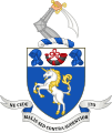
Coat of arms of Roxburghshire County Council 1890–1962.
-
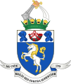
Coat of arms of Roxburghshire County Council 1962–1975.
-
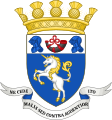
Coat of arms of Roxburghshire District Council 1975–1996.


Civil Parishes

After some boundary changes in 1889, Roxburghshire was divided into 30 civil parishes. These are like smaller local areas.
Towns and Villages in Roxburghshire


Roxburghshire is home to many towns and villages, including:
- Ancrum
- Bonchester Bridge
- Bowden
- Denholm
- Hawick
- Jedburgh
- Kelso
- Melrose
- Newcastleton
- Newtown St Boswells
- St Boswells
- Tweedbank
Famous People from Roxburghshire
Many notable people have connections to Roxburghshire:
- Robert Livingston the Elder (1654–1728) was born in Ancrum. He became an important figure in New York Province.
- Thomas Pringle (1789–1834), a Scottish writer, poet, and activist against slavery, was born near Kelso.
- Henry Scott Riddell (1798–1870), a poet, is remembered with a monument near Teviothead.
- Thomas B. Scott (1829–1886) became President Pro Tem of the Wisconsin State Senate in the United States.
See Also
