
Southern Uplands facts for kids
The Southern Uplands are the most southern part of mainland Scotland. They are also the least populated of Scotland's three main areas. The other two are the Central Lowlands and the Highlands. The name "Southern Uplands" describes both the land area and the many hills and mountains found there. This region is mostly rural, meaning it has lots of countryside and farms. It has forests and open moorland, which are areas of wild, open land.
Contents
Geology: How the Land Was Made
The Southern Uplands are mostly made of sedimentary rocks that formed a very long time ago, about 400 to 500 million years ago. These rocks were laid down at the bottom of an ancient ocean called the Iapetus Ocean.
Around 400 million years ago, huge pieces of the Earth's crust (called continents and terranes) crashed into each other. This event, known as the Caledonian orogeny, pushed the rocks up from the seabed. This created the hills and valleys we see today. The word "Caledonian" comes from "Caledonia," an old Latin name for Scotland. Most of these rocks are a type of sandstone called greywacke.
Because of these powerful movements, many large cracks in the Earth's crust, called faults, formed across the Southern Uplands. These faults run from east to west. Rivers often follow these fault lines, creating the valleys in the region. Some special springs in the area, like those near Moffat, have been popular places for visitors.
Geography: Hills, Rivers, and Lochs
The Southern Uplands are located south of the Southern Uplands Fault. This fault line stretches about 220 kilometers (137 miles) from Ballantrae on the west coast to Dunbar on the east coast, by the North Sea.
Hill Ranges
The Southern Uplands have several groups of hills and mountains. Here are some of them, listed from east to west:
- Cheviot Hills: These hills are on the border between Scotland and England.
- Lammermuir Hills: Found south of Dunbar.
- Moorfoot Hills: Located south of Edinburgh.
- Tweedsmuir or Manor Hills: South of Tweedsmuir.
- Culter Hills: South of Biggar.
- Moffat Hills: North-east of Moffat.
- Ettrick Hills: South of Moffatdale.
- Lowther Hills: Between the areas of Clydesdale/Annandale and Nithsdale.
- Carsphairn and Scaur Hills: Between Nithsdale and the Glenkens.
- Galloway Hills: West of the Glenkens. This is a large area with smaller ranges like The Awful Hand, Dungeon Hills, Rhinns of Kells, and Minnigaff Hills.

Highest Peaks
Even though the peaks in the Southern Uplands are not as high as those in the Scottish Highlands, some parts are wild and mountainous. There are about 120 "Marilyns" here, which are hills with a drop of at least 150 meters (492 feet) on all sides.
Some of the most famous peaks are:
- Merrick: The highest in the south of Scotland at 843 meters (2,766 feet).
- Broad Law: 840 meters (2,756 feet).
- White Coomb: 822 meters (2,697 feet).
- The Cheviot: 815 meters (2,674 feet).
- Corserine: 814 meters (2,671 feet).
- Cairnsmore of Carsphairn: 797 meters (2,615 feet).
- Kirriereoch Hill: 786 meters (2,579 feet).
- Shalloch on Minnoch: 769 meters (2,523 feet).
The Southern Uplands are also home to the UK's highest village, Wanlockhead, which is 430 meters (1,411 feet) above sea level.

Rivers and Lochs
Many rivers flow through this region. The most important ones are Scotland's third and fourth longest rivers: the River Clyde, which is 106 miles (171 km) long, and the River Tweed, which is 97 miles (156 km) long. Several other important rivers flow south into the Solway Firth and Irish Sea, including the River Cree, River Dee, River Nith, River Annan, and the River Esk.
There are also many lochs (lakes) in the Southern Uplands, especially in the west. The biggest is Loch Ken, which was created by damming the Water of Ken. Other lochs in Galloway, like Loch Doon and Clatteringshaws Loch, have also been dammed. However, many smaller lochs like Loch Dee and Loch Enoch are still in their natural state.
East of Moffat, you'll find the largest natural body of water in the Southern Uplands, St Mary's Loch, along with the nearby Loch of the Lowes and Loch Skeen.

Wildlife
The Southern Uplands are home to many different kinds of animals and plants. The uplands support birds like black and red grouse, and raptors such as golden eagles and hen harriers. You can also find mountain hares here.
In the western hills, you might see red deer, roe deer, and wild goats. The forests in the west are home to a large number of red squirrels. Ospreys can be seen near St Mary's Loch and along the River Tweed. Many streams have Brown trout, and some rivers have sea trout, salmon, and otters.
Transport
The Southern Uplands have always been a bit of a challenge for travel between Scotland's busy Central Belt and England. Major roads and railways usually follow the east coast or various river valleys.
Road
Several main roads cross the Southern Uplands, mostly running north to south. The most important is the M74 motorway, which connects Scotland and England. Other key roads include:
- A77: From Stranraer towards Glasgow.
- A76: From Dumfries towards Kilmarnock.
- A701: From Dumfries towards Edinburgh, passing through Moffat and the Devil's Beef Tub.
- A7: From Carlisle to Edinburgh, going through Hawick and Galashiels.
- A75: From Gretna through Dumfries and Galloway to Stranraer.

Rail
Five railway lines pass through or into the Southern Uplands, all generally running north to south:
- The West Coast Main Line: Connects Glasgow and Edinburgh with Carlisle and England. There's a station at Lockerbie in the Southern Uplands.
- The East Coast Main Line: Runs from Edinburgh to Berwick-upon-Tweed and further south.
- The line from Stranraer to Glasgow.
- The line from Glasgow to Kilmarnock and Carlisle, via Dumfries.
- The Borders Railway: Links Edinburgh to Tweedbank in the Scottish Borders, passing through Stow and Galashiels.
Recreation
The Southern Uplands offer many outdoor activities.
Walking
There are many walking paths. One famous path is the Southern Upland Way, which is a 212-mile (341 km) walk from coast to coast, stretching from Portpatrick in the west to Cockburnspath in the east.

Climbing
The Galloway Hills in the western part of the Southern Uplands offer good rock climbing. The rocks are mostly granite. In cold winters, you can also find good ice climbing on hills like Craignaw and Merrick.
Mountain Biking
The 7stanes are seven special mountain biking centers located across the south of Scotland. They are built on Forestry Commission land and are considered some of the best trails in the UK. They are called "7stanes" because each place has a unique "stane" (which means stone in Scots) along its trails.
The Seven Stanes locations are:
- Glentrool
- Kirroughtree (near Newton Stewart)
- Dalbeattie
- Mabie
- Forest of Ae
- Tweed Valley (including Glentress and Innerleithen)
- Newcastleton
Culture
The Southern Uplands, especially the areas near the border with England, have a long and sometimes difficult history. Many battles and raids happened here. Festivals like the Common Riding in towns such as Jedburgh, Hawick, and Selkirk remember this history. During these festivals, people ride horses around the town boundaries, just as people used to do to watch out for raids from the south.
This history is also told in many old songs called Border ballads. These songs often tell stories of battles or even supernatural events. Sir Walter Scott collected many of these ballads in his book Minstrelsy of the Scottish Border. He also wrote about the history and traditions of the Southern Uplands in his other works, as did James Hogg, who was known as the Ettrick Shepherd.
Economy
Farming and forestry are the main ways people use the land in the Southern Uplands. For many years, the area has also produced clean energy. The Galloway hydro-electric power scheme was built in the 1930s. More recently, several wind farms have been built on the hills. Tourism and outdoor activities like walking, fishing, and mountain biking are also becoming very important.
The textile industry (making cloth and clothes) used to employ many people in towns in the Scottish Borders during the 19th and 20th centuries. Even though the textile industry has become smaller since the late 20th century, it is still important for the local economy.
Agriculture
In the eastern part of the Southern Uplands (the Scottish Borders), sheep farming and growing crops are more common. In Dumfries and Galloway in the west, dairy farming (raising cows for milk) used to be more important, but now more sheep are being raised there too. Some types of farm animals, like Galloway cattle and Cheviot sheep, first came from the Southern Uplands.
Forestry
Large parts of the Southern Uplands are covered by forests, including:
- Forest of Ae
- Mabie Forest
- Galloway Forest
The amount of forest in the western Southern Uplands grew a lot between the 1940s and the 1980s.
Images for kids
-
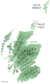
Southern Uplands and other geographical areas of Scotland
-
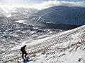
Loch Skene to Mid Craig and White Coomb from Lochcraig Head.
-
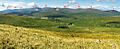
Rhinns of Kells Range from the Carsphairn Hills
-
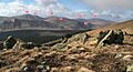
01 Dungeon Hill – 02 Merrick – 03 Little Spear of Merrick – 04 Kirriereoch – 05 Mullwharchar – 06 Tarfessock – 07 Shalloch on Minnoch – 08 Hoodens Hill.
_Named_(HR).png)


See also
 In Spanish: Southern Uplands para niños
