Scottish Lowlands facts for kids
Quick facts for kids
Lowlands
|
|
|---|---|

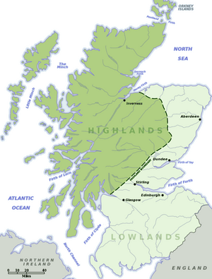
The Lowlands, shown in light green
|
|
| Country | Scotland |
| Demonym(s) | Lowlander |
| Time zone | UTC+0 (GMT) |
| • Summer (DST) | UTC+1 (BST) |
The Lowlands (also called Scots: Lallans or Lawlands) is a special cultural and historical region in Scotland. The name Scottish Gaelic: a' Ghalldachd means "place of the foreigners" in Scottish Gaelic.
This area is known for its mostly flat or gently rolling land. This is different from the tall mountains you find in the Scottish Highlands. The Lowlands include big cities like Edinburgh and Glasgow. It has fertile farmland, many historic sites, and busy city centers. More people live here, and there are more industries than in the Highlands.
Over time, the Lowlands and the Highlands developed different cultures. This happened from the Late Middle Ages into modern times. In most of the Lowlands, the Lowland Scots language replaced Scottish Gaelic.
Contents
What Makes the Lowlands Unique?
The Lowlands are not an official area on a map. But people use the name to describe a large part of Scotland. It usually means the areas that are not in the Highlands.
The boundary line is often thought to be between Stonehaven and Helensburgh. This line runs across Scotland. The Lowlands are south and east of this line. Even though it's called "Lowlands," some parts are not actually low. For example, Merrick is a hill that reaches about 843 meters (2,766 feet) high. Also, some places in the Highlands, like Islay, are quite flat.
Counties in the Lowlands
Many traditional Scottish counties are fully in the Lowlands. These include Ayrshire, Berwickshire, Clackmannanshire, Dumfriesshire, East Lothian, Fife, Kinross-shire, Kirkcudbrightshire, Lanarkshire, Midlothian, Peeblesshire, Renfrewshire, Roxburghshire, Selkirkshire, West Lothian, and Wigtownshire.
Some other counties are split by the boundary line. These include Angus, Dunbartonshire, Stirlingshire, Perthshire, Kincardineshire, Aberdeenshire, Banffshire, and Moray.
Geography of the Lowlands
Scotland has three main geographical areas. These are the Highlands, the Central Plain (also called the Central Belt), and the Southern Uplands. The Lowlands generally cover the Central Plain and the Southern Uplands. The northeast plain is also low and flat. Sometimes it is grouped with the Highlands, but it is geographically part of the Lowlands.
The Central Lowlands
The term "Lowlands" often refers specifically to the "Central Lowlands". This area is also known as the "Midland Valley". It mainly includes the areas around the Rivers Forth and Clyde. About 80 percent of Scotland's population lives here. That's about 3.5 million people!
Historically, the Midland Valley was Scotland's best farming region. In the 1800s and early 1900s, it grew a lot. This was because of coal and heavy industries. Even though these industries have slowed down, the Midland Valley is still very important. Today, it is a main center for Scotland's economy. It focuses on electronics, computer making, and service jobs. These include telecommunications, computer software, and finance.
The Scottish Borders
The counties in the very south of Scotland are called the Borders. They are close to the border with England. Sometimes, people talk about them separately from the rest of the Lowlands.
Many people from the Lowlands and Borders moved away long ago. They went to places like the Ulster Plantation in the 1600s. Later, many moved to the American frontier. These people are sometimes called Scotch-Irish or Ulster-Scots.
Culture and History
The term Scottish Lowlands is used when talking about the Scots language. This is different from the Scottish Gaelic spoken in the Highlands. Historically, Gaelic was also spoken in the Lowlands until the 1400s. In Galloway, it was spoken until the 1700s.
The Lowlands are also important in Scottish history. They are part of understanding the Scottish clan system. They are also key for family history and genealogy.
See also
 In Spanish: Tierras Bajas de Escocia para niños
 | James Van Der Zee |
 | Alma Thomas |
 | Ellis Wilson |
 | Margaret Taylor-Burroughs |

