
Islay facts for kids
| Gaelic name | Ìle |
|---|---|
| Norse name | Íl |
| Meaning of name | Unknown |
| OS grid reference | NR370598 |
| Coordinates | 55°46′N 6°09′W / 55.77°N 6.15°W |
| Physical geography | |
| Island group | Islay |
| Area | 61,956 ha (239.21 sq mi) |
| Area rank | 5 |
| Highest elevation | Beinn Bheigeir, 491 m (1,611 ft) |
| Administration | |
| Sovereign state | United Kingdom |
| Country | Scotland |
| Council area | Argyll and Bute |
| Demographics | |
| Population | 3,228 |
| Population density | 5.2/km2 (13/sq mi) |
| Largest settlement | Port Ellen |
Islay (pronounced EYE-lə) is a beautiful island in Scotland. It's the most southern island of the Inner Hebrides. People often call it "The Queen of the Hebrides" because it's so special. Islay is located in Argyll, just southwest of Jura. It's also about 40 kilometers (25 miles) north of the coast of Northern Ireland.
The main town on Islay is Bowmore. Here you can find the unique round Kilarrow Parish Church and a famous whisky distillery. Port Ellen is the island's busiest port. Islay is the fifth-largest Scottish island. It's also the eighth-largest island in the British Isles. Its total area is nearly 620 square kilometers (240 square miles).
People have lived on Islay for a very long time, even before written history. The island became part of the Gaelic Kingdom of Dál Riata in the Early Middle Ages. Later, it joined the Norse Kingdom of the Isles. The time after the Middle Ages was very important for Islay's culture. The Hebrides became part of Scotland, and the powerful Clan Donald Lordship of the Isles began, with its main center at Finlaggan.
In the 1600s, the power of Clan Donald lessened. But farming and transport got better, so more people lived on the island. The population was highest in the mid-1800s. After that, many people were forced to leave their homes during the Highland Clearances. This caused the number of residents to drop.
Today, Islay has over 3,000 people living there. The main jobs are farming, making malt whisky, and tourism. The island has a long history of religious life. About a quarter of the people still speak Scottish Gaelic. Islay's beautiful scenery has been shown in many artworks. There's also growing interest in renewable energy here. Islay is a great place for birdwatchers. Many bird species live here, including large groups of Greenland white-fronted and barnacle goose in winter. The weather on Islay is usually mild because of the Gulf Stream.
Contents
Discovering Islay's Name and History

The name Islay might have come from an old word Epidion, used by a Greek mapmaker named Ptolemy in the 1st century AD. Later, in the 600s, a writer named Adomnán called the island Ilea. The name also appeared as Ile in old Irish records and Íl in Old Norse. No one knows for sure where the name comes from, but it's not Gaelic.
In maps from the 1600s, Islay was spelled "Yla" or "Ila". You can still see this in the name of the whisky Caol Ila. In poems, Islay is called "Queen of the Hebrides" or "the green isle of Islay". Someone from Islay is called an Ìleach.
Many place names on Islay come from a mix of Norse, Gaelic, and English words. For example, Port Askaig comes from the Norse words for "ash tree bay". Many Gaelic names are also common, like Ardnave Point, which means "height of the saint". Some villages, like Port Charlotte, were named in the 1700s and 1800s. Port Charlotte was named after Lady Charlotte Campbell, whose husband owned the island.
Exploring Islay's Geography

Islay is about 40 kilometers (25 miles) long from north to south. It is about 24 kilometers (15 miles) wide. The east coast is rough and has mountains. These mountains rise steeply from the Sound of Islay. The highest point is Beinn Bheigeir, which is 491 meters (1,612 feet) tall.
The western parts of the island are separated from the main land by Loch Indaal in the south and Loch Gruinart in the north. The fertile, windy southwest part is called The Rinns. Ardnave Point is a noticeable piece of land on the northwest coast. The south coast is protected from strong winds and has more trees. Islay's coastline has many bays and sea lochs, like Loch an t-Sailein and Aros Bay. In the far southwest is a rocky area called The Oa. This is the closest point in the Hebrides to Ireland.
Most of Islay's people live in or near Bowmore and Port Ellen. Other smaller villages include Bridgend, Ballygrant, Port Charlotte, Portnahaven, and Port Askaig. The rest of the island has fewer people and is mostly used for farming.
There are many small freshwater lochs (lakes) in the middle of the island. These include Loch Finlaggan, Loch Ballygrant, and Loch Gorm. Many small streams, called "burns," flow across the island. The most important ones are the River Laggan and the River Sorn.
Around Islay's coasts are many small, uninhabited islands. The biggest ones are Eilean Mhic Coinnich and Orsay off the Rinns. Nave Island is on the northwest coast, and Texa is off the south coast.
Islay's Rocks and Landforms

The rocks under Islay are very complex for such a small area. The oldest rocks are called gneiss, which are very old igneous rocks. These are found in the Rinns area. Other parts of the island have different types of rocks. These include quartzite, schist, and limestone. The island's shape is also affected by a large geological fold called the Islay Anticline.
Loch Indaal was formed by a crack in the Earth's crust called the Loch Gruinart Fault. This fault is connected to the larger Great Glen Fault. Because of these faults, small earth tremors sometimes happen on Islay.
Evidence of an ice age from a very long time ago (Precambrian period) can be seen near Port Askaig. More recently, during the Pleistocene ice ages, most of Islay was covered by ice. Only the top of Beinn Tart a' Mhill was not covered. As the ice melted, sea levels changed, leaving behind raised beaches along the coast. In ancient times, the low land between the Rinns and the rest of Islay was often flooded, making it seem like two separate islands.
Islay's Climate and Weather
The Gulf Stream helps keep Islay's weather mild. Snow is rare at sea level, and frosts are light and don't last long. However, winds are strong, averaging 19 to 28 kilometers per hour (10 to 15 knots) each year. Winter storms from the Atlantic can have gusts up to 185 kilometers per hour (115 mph). These strong winds can make travel difficult in winter. Ferries and flights to the mainland can be delayed.
The driest months are April to July. The warmest months are May to September. These are the busiest times for tourists. The coasts, especially in the west, usually get the most sunshine.
| Climate data for Islay: Port Ellen climate station (17m elevation) 1981–2010 averages | |||||||||||||
|---|---|---|---|---|---|---|---|---|---|---|---|---|---|
| Month | Jan | Feb | Mar | Apr | May | Jun | Jul | Aug | Sep | Oct | Nov | Dec | Year |
| Mean daily maximum °C (°F) | 7.8 (46.0) |
7.6 (45.7) |
9.1 (48.4) |
11.0 (51.8) |
13.9 (57.0) |
15.8 (60.4) |
17.1 (62.8) |
17.1 (62.8) |
15.6 (60.1) |
12.9 (55.2) |
10.0 (50.0) |
8.2 (46.8) |
12.2 (54.0) |
| Mean daily minimum °C (°F) | 2.6 (36.7) |
2.2 (36.0) |
3.1 (37.6) |
4.2 (39.6) |
6.4 (43.5) |
8.9 (48.0) |
10.9 (51.6) |
11.0 (51.8) |
9.6 (49.3) |
7.5 (45.5) |
4.9 (40.8) |
3.0 (37.4) |
6.2 (43.2) |
| Average rainfall mm (inches) | 138.2 (5.44) |
98.2 (3.87) |
118.8 (4.68) |
77.9 (3.07) |
62.4 (2.46) |
73.3 (2.89) |
78.8 (3.10) |
106.7 (4.20) |
114.6 (4.51) |
148.7 (5.85) |
132.3 (5.21) |
132.9 (5.23) |
1,282.7 (50.50) |
| Average rainy days (≥ 1.0 mm) | 19.9 | 14.8 | 17.8 | 13.3 | 11.6 | 11.4 | 13.8 | 15.4 | 15.5 | 19.7 | 19.3 | 18.6 | 191.1 |
| Source: metoffice.gov.uk | |||||||||||||
Islay's Ancient Past

The first people on Islay were hunter-gatherers. They probably arrived during the Mesolithic period after the ice melted. An arrowhead found near Bridgend in 1993 dates back to 10,800 BC. This is some of the earliest proof of humans in Scotland. Other ancient tools found in 2015 suggest hunters used the coast in summer. By the Neolithic period, people started living in one place. This allowed them to build large monuments together.
The most impressive ancient structure on Islay is Dun Nosebridge. This Iron Age fort is on a high rock. It offers amazing views of the land around it. Its name likely comes from a mix of Gaelic and Old Norse words meaning "fort on the crag". There is no sign that the Romans ever controlled Islay with their army. However, a few Roman items found here suggest some connections with the Romans on the mainland.
The ruins of a broch (a type of round tower) at Dùn Bhoraraic and other roundhouses show influences from northern Scotland. Islay also has several crannogs (ancient lake dwellings). You can see one in Loch Allallaidh, where a stone path to two islands is visible under the water.
Islay's Rich History

Early Kingdoms and Norse Influence
By the 500s AD, Islay was part of the Gaelic kingdom of Dál Riata. This kingdom had strong ties to Ireland. Many believe that Gaelic people from Ireland moved to Scotland and formed Dál Riata. However, some think the Gaels were already living in this part of Scotland. Dál Riata was divided into areas, each ruled by a family group. For Islay and Jura, it was the Cenél nÓengusa family.
In 627, a king's son from Ireland was killed on Islay. The Senchus fer n-Alban (an old history book) also mentions what might be the oldest record of a naval battle in the British Isles. This was a fight between rival Dál Riatan groups in 719.
In the 800s, Viking settlers from Scandinavia arrived. This changed the Dál Riata kingdom forever. Place names on Islay show a strong Norse influence. Even though Gaelic was still spoken, it seemed to have a lower status. This might mean the local people were enslaved.
The Norse settlers created the Kingdom of the Isles. This kingdom later became part of Norway. The islands were called Suðreyjar (meaning southern isles). For over 400 years, rulers of Norse background controlled this sea kingdom.

Godred Crovan was an important ruler of this sea kingdom. He was a Norse-Gael and had a connection to Islay. He was so powerful that he "tamed the Scots." Godred also became King of Dublin. He died on Islay in 1095 from a sickness. A local story says a standing stone at Carragh Bhan marks his grave. An 11th-century Norse grave-slab was found in 1838. It has Viking art and an Irish-style cross.
After Godred's death, the people of Islay didn't want Norway's chosen ruler. So, Magnus, the Norwegian king, came to Islay with his army. In 1098, the king of Scotland gave all his power over the islands to Magnus.
Somerled and the Lords of the Isles

In the mid-1100s, a granddaughter of Godred Crovan married Somerled. He was a powerful Norse-Gaelic nobleman from Argyle. Godred Olafsson, Godred Crovan's grandson, was not a popular king. Somerled fought him in a sea battle off Islay in 1156. The battle was a tie, and the island kingdom was split. Somerled took control of the southern Hebrides. Two years later, Somerled took over the whole kingdom.
Somerled built Claig Castle, a sea fortress, between Islay and Jura. This helped him control the Sound of Islay. Because of the Corryvreckan whirlpool north of Jura, the Sound was the safest sea route. Claig Castle gave Somerled control over all sea traffic. After Somerled died in 1164, his kingdom was divided. His grandson, Donald, received Islay and Claig Castle.
Norway's power was re-established after Somerled's death. But in the mid-1200s, fighting between Norway and Scotland grew. This led to the Battle of Largs. Soon after, the Norwegian king died. In 1266, Norway gave up its power over the islands to the Scottish king, Alexander III. This was part of the Treaty of Perth, where Scotland paid a large sum of money. The islands became a Scottish crown dependency, not fully part of Scotland.
Scottish Rule and Clan Power
The Lords of the Isles

By this time, Somerled's family had split into three main groups: the MacDonalds, the Macruari, and the MacDougalls. When Robert the Bruce fought for the Scottish throne, the MacDougalls supported his rival. But the Macruari and MacDonalds supported Robert. When Robert won, he took the MacDougall lands and gave them to the MacDonalds and Macruari.
The Macruari lands eventually went to Amy of Garmoran. She married her cousin, John of Islay, in the 1330s. John became the head of the MacDonalds. He now controlled a large part of western Scotland and all the Hebrides except Skye. From 1336, John called himself Dominus Insularum—"Lord of the Isles". This title showed he felt somewhat independent from the Scottish king. The MacDonalds became very powerful, like kings themselves.

Their main base was at Loch Finlaggan in northeastern Islay. New Lords of the Isles were crowned here on an old stone with footprints. They stood barefoot and were blessed by a bishop and priests. The Lord's "Council of the Isles" met on Eilean na Comhairle (Council Island) in Loch Finlaggan.
The Islay Charter from 1408 is an important historical document. It's one of the earliest records of Gaelic being used in public. In 1437, the Lordship grew even bigger when Alexander, the Lord of the Isles, inherited the rule of Ross. This included Skye. As the MacDonalds grew stronger, the heart of their Lordship moved to castles in the Sound of Mull.

In 1462, the last and most ambitious Lord, John MacDonald II, made a secret deal with the king of England. Their goal was to conquer Scotland. But a war in England stopped the plan. In 1475, the Scottish king found out about the deal. John had to give up his mainland lands and Skye. But he didn't give up his ambition easily. His nephew tried to raid Ross, but it failed. By 1493, MacDonald had to give up all his lands and titles to James IV of Scotland. Islay and the other lands became part of Scotland.
King James ordered Finlaggan to be destroyed. Its buildings were torn down, and the coronation stone was broken. This was to stop anyone from trying to bring back the Lordship.
The 16th and 17th Centuries

The Clan MacDonald of Dunnyveg got their lands back in Islay in 1545. The MacLean family had been given land in Jura by the MacDonalds in 1390. So, in 1493, a branch of the MacLeans was given Dunyvaig Castle by King James. They then expanded into Islay. This caused problems when the MacDonalds got their lands back. The MacLeans were forced out of Loch Gorm in 1578. In 1598, they were finally defeated at the Battle of Traigh Ghruinneart.
However, the MacDonalds became unpopular in Edinburgh. Their use of Gaelic was seen as "barbaric." Also, they didn't support the Scottish reformation. In 1608, the Scottish-English king sent an army to control them. In 1614, the king gave Islay to Sir John Campbell of Cawdor. He promised to bring peace to the island, which the Campbells eventually did. The Campbells then controlled the island as landlords.
The Civil War made things complicated. Archibald Campbell, 8th Earl of Argyll, the head of the Campbells, led the Covenanter government. But other Campbells supported the Royalists. A Covenanter army came to Islay in 1647. They attacked the Royalist fort at Dunnyvaig and damaged the island. It wasn't until 1677 that the Campbells felt safe enough to build Islay House at Bridgend. This became their main home on the island.
Islay in the British Era
The 18th and 19th Centuries
.JPG)
In the early 1700s, most people in Argyll lived in small farming villages. On Islay, there were only two main villages: Killarow (near Bridgend) and Lagavulin. Killarow was later destroyed in the 1760s to make the grounds of Islay House look better. The island's economy relied on farming crops like barley and oats, and raising animals. In 1722, records show the island could support over 6,600 cows and 2,200 horses.
In 1726, Daniel Campbell of Shawfield bought Islay. After some rebellions, a law in 1746 removed the Campbells' official power as sheriffs. They could only influence the island as landlords.
The 1800s brought better transport to Argyll. Roads were built, and the Crinan Canal made sea travel to Glasgow shorter. New docks were built at Port Askaig and other places on Islay. People were hopeful about fishing and cattle trading. The population grew, partly because of the "kelp boom" (collecting seaweed for chemicals) and the introduction of potatoes. Islay's population was about 5,344 in 1755. It grew to over 15,000 by 1841.
Islay stayed with the Campbells of Shawfield until 1853. Then, James Morrison bought it. His family still owns a large part of the island today. When landowners realized they could make more money from sheep farming than from small farmers, many people were forced off their land. This was part of the Highland Clearances. In 1863 alone, 400 people left Islay. Many were forced to leave homes their families had farmed for centuries. By 1891, the population was only 7,375. Many people moved to Canada, the United States, and other places. The population kept falling for most of the 1900s. Today, it's about 3,500.
In 1899, Islay officially became part of the County of Argyll.
World Wars and Islay

During World War I, two troop ships sank off Islay in 1918. The American ship SS Tuscania was hit by a torpedo on February 5. Over 160 lives were lost. On October 6, HMS Otranto crashed into another ship in bad weather. Otranto lost control and drifted towards the west coast of the Rinns. Another destroyer, HMS Mounsey, rescued over 350 men. But Otranto was wrecked near Machir Bay, and 431 lives were lost. The American Red Cross built a monument on The Oa to remember these ships. A military cemetery was made at Kilchoman for the dead from both nations.
During World War II, the RAF built an airfield at Glenegedale. This later became Islay's civil airport. The RAF also had a flying boat base at Bowmore from 1941. In 1944, a Canadian RAF flying boat crashed near Bowmore. Its crew was rescued, but the plane sank. There were also RAF radar stations at Saligo Bay and Kilchiaran.
Islay's Economy and Activities
The main parts of Islay's economy today are farming, fishing, distilling (making whisky), and tourism.
Farming and Fishing on Islay

Most of Islay is still owned by a few people who don't live on the island. Sheep farming and a few dairy cow herds are run by farmers who rent the land. Some areas of high moorland are used for hunting deer. Some bogs are cut for peat, which is used as fuel by a few distilleries and homeowners. The southeast and eastern parts of Islay also have some forests with pine trees.
Islay is great for fishing brown trout and salmon. In September 2003, a big European Fishing Competition was held on five of Islay's many lochs. Sea angling (fishing with a rod and line) is also popular, especially off the west coast. There are about 20 commercial fishing boats. They catch crab, lobster, and scallops from Port Askaig, Port Ellen, and Portnahaven.
Whisky Distilling on Islay

Islay is one of five special areas in Scotland known for making Scotch whisky. Its whisky identity is protected by law. There are nine active distilleries on the island, and plans for an eleventh. This industry is the island's second-largest employer after farming.
The distilleries on the south of the island make whiskies with a very strong peaty flavor. These are considered the most intensely flavored whiskies. From east to west, they are Ardbeg, Lagavulin, and Laphroaig. On the north of the island, Bowmore, Bruichladdich, Caol Ila, Bunnahabhain, and Ardnahoe whiskies are made. These are much lighter in taste. Kilchoman is a smaller distillery that opened in 2005 on the west coast of the Rinns.

The oldest record of a legal distillery on Islay is Bowmore in 1779. At one time, there were up to 23 distilleries working. For example, Port Charlotte distillery operated from 1829 to 1929. Port Ellen distillery is also closed, but it still prepares malted barley for other distilleries. In 2007, Bruichladdich announced they would reopen Port Charlotte distillery.

Islay whiskies are known for their "peaty, smoky, and oily flavors, with a hint of salty sea air and seaweed." This is because of the peat used and the island's sea climate. Distilleries in the south use malt with a lot of peat and peaty water. This makes their whisky "medium-bodied... saturated with peat-smoke, brine and iodine." Whisky from the northern area is milder. It uses spring water for a "lighter flavored, mossy (not as peaty), with some seaweed, some nuts..." taste.
In the future, the whisky industry on Islay might make a wider range of products. Some might be less peaty, and there could be new types of whisky.
Tourism on Islay
About 45,000 visitors come by ferry each summer, and another 11,000 by plane. The main reasons people visit are the beautiful scenery, history, bird watching, and the world-famous whiskies. The distilleries offer shops, tours, and visitor centers. The Finlaggan Trust also has a visitor center open in summer.
You can play golf on the 116-year-old Machrie golf course. It was redesigned and reopened in 2017. The nearby Machrie Hotel was also rebuilt. Walkers and cyclists enjoy the 210 kilometers (130 miles) of coastline. Bird watchers will also find plenty to see.
According to a report from July 2018, some summer days see nearly 6,000 tourists on the island. Over 15,000 visit during the Feis Ile whisky festival in May. These are very high numbers for an island with about 3,200 residents. This has led to some worries that the special feel of Islay is changing. Still, there are no large hotels on the island yet. Tourists stay in guest houses, B&Bs, small hotels like the Port Charlotte Hotel, self-catering cottages, and a youth hostel. There are also two campsites, one for motorhomes.
Renewable Energy on Islay

Islay is exposed to the strong forces of the North Atlantic Ocean. This makes it a great place for wave power. Scotland's first wave power station is near Portnahaven. The Islay LIMPET (Land Installed Marine Powered Energy Transformer) wave power generator was built by Wavegen and Queen's University of Belfast. It was supported by the European Union. Known as Limpet 500, it can provide up to 150 kW of electricity to the island's power grid. In 2000, it became the world's first commercial wave power station.
In March 2011, the Scottish Government approved the world's largest tidal array project. Ten turbines are planned to generate enough power for over 5,000 homes. This project will be in the Sound of Islay. This area has strong currents and is protected from storms.
In July 2019, it was announced that Atlantis Resources plans to build a tidal array in the Sound of Islay. This project could eventually provide up to 10 MW of clean energy.
Transport on Islay

Many roads on Islay are single-track roads with passing places. The two main roads are the A846 from Ardbeg to Port Askaig (passing Port Ellen and Bowmore). The A847 runs along the east coast of the Rinns. Islay has its own bus service, Islay Coaches. Glenegedale Airport offers flights to and from Glasgow International Airport. There are also less frequent flights to Oban and Colonsay.
Caledonian MacBrayne runs regular ferry services to Port Ellen and Port Askaig from Kennacraig. The journey takes about two hours. Ferries from Port Askaig also go to Scalasaig on Colonsay. On summer Wednesdays, they go to Oban. A special ferry, MV Finlaggan, started service in 2011. A small car ferry also runs from Port Askaig to Feolin on Jura. Kintyre Express offers passenger-only services between Port Ellen and Ballycastle in Northern Ireland from June to August.

There are several lighthouses on and around Islay to help ships navigate. These include the Rinns of Islay light on Orsay, built in 1825. Ruvaal is at the northeast tip of Islay, built in 1859. Carraig Fhada at Port Ellen has a unique design. Dubh Artach is an isolated rock tower about 35 kilometers (22 miles) northwest of Ruvaal.
Other Interesting Activities
Since 1973, the Ileach newspaper has delivered news to Islay every two weeks. It was named community newspaper of the year in 2007. The Islay Ales Brewery makes different real ales near Bridgend. In the early 2000s, a campus of Sabhal Mòr Ostaig was set up on Islay. This center, called Ionad Chaluim Chille Ìle, teaches Gaelic language, culture, and history. The Port Mòr community center at Port Charlotte is a great example of local effort. It has a micro-wind turbine and a ground-source heating system.
The Gaelic Language on Islay
Islay has always been a strong Gaelic-speaking area. In the 1901 and 1921 censuses, over 75 percent of people in all Islay parishes spoke Gaelic. By 1971, the Rinns had 50–74 percent Gaelic speakers. The rest of Islay had 25–49 percent Gaelic speakers. In 1991, about a third of the island's people spoke Gaelic. In the 2001 census, this dropped to 24 percent. While this is lower, it still made Islay the strongest Gaelic-speaking island in Argyll and Bute after Tiree. The highest percentage was in Portnahaven (32 percent), and the lowest in Gortontaoid (17 percent).
The Islay Gaelic dialect is special. It is very similar to other Argyll dialects, especially those of Jura, Colonsay, and Kintyre. It has unique sounds and words. For example, they say dhuit for "to you" instead of the more common dhut. They also use gun robh math agad for "thank you" instead of mòran taing.
Religion and Ancient Sites

Many churches on Islay have cupstones. These are stones with carved hollows of unknown age. You can see them at Kilchoman Church and Kilchiaran Church. In old times, some might have been used for pre-Christian ceremonies or beliefs in the "wee folk" (fairies).
Early Christian leaders like Columba of Iona and Moluag of Lismore brought Christianity to Dál Riata. A famous treasure from this time is the 8th-century Kildalton Cross. It is carved from local stone. Another old, weathered cross can be found at Kilnave.
Even though the first Norse settlers were pagan, Islay has many small stone chapels with burial grounds from the later Norse period. In the 1100s, Islay became part of the Diocese of the Isles. This diocese was under the control of Norway. There were four main churches on Islay: Kilnaughton, Kildalton, Kilarrow, and Kilmany. In 1472, Islay became part of the Archdiocese of St Andrews.

Archibald Campbell, 5th Earl of Argyll, strongly supported the Reformation. But it seems the islanders were not very enthusiastic about it at first. Initially, there were only two Protestant churches. But in 1642, three parishes were created. By the end of the century, there were seven churches, including one on Nave Island. Kilarrow Parish Church, built in 1767, is round. Local stories say it has no corners for the devil to hide in. St Kiaran's is the kirk on the Rinns of Islay, near Port Charlotte. Port Ellen has St John's. There are also other Church of Scotland churches and different Christian groups on the island. Baptists meet in Port Ellen and Bowmore. The Scottish Episcopal Church of St. Columba is in Bridgend. The Islay Roman Catholic community also uses St Columba's for its services.
Islay in Media and Arts
Islay was featured in some scenes of the 1954 film The Maggie. The 1942 documentary "Coastal Command" was partly filmed in Bowmore.
In 1967–68, folk-rock singer Donovan included "The Isle of Islay" on his album, A Gift from a Flower to a Garden. It's a song praising the island's beautiful countryside. "Westering Home" is a Scottish song from the 1900s about Islay.
In the 1990s, the BBC show Para Handy was partly filmed in Port Charlotte and Bruichladdich. It showed a race between the Vital Spark (Para Handy's boat) and a rival along Loch Indaal. In 2007, parts of the BBC Springwatch program were filmed on Islay. The British Channel 4 TV show Time Team dug at Finlaggan. That episode first aired in 1995.
In 2000, Japanese author Haruki Murakami visited Islay to try seven single malt whiskies. He later wrote a travel book called If our language were whisky.
Islay's Amazing Wildlife

Islay is home to many kinds of wildlife. It is especially famous for its birds. In recent years, the number of barnacle gooses visiting in winter has reached 35,000. As many as 10,000 can arrive in a single day. There are also up to 12,000 Greenland white-fronted geese. Smaller numbers of brent, pinkfooted, and Canada geese are often seen with these flocks.
Other water birds include whooper and mute swans, eider duck, Slavonian grebe, goldeneye, long-tailed duck, and wigeon. The shy corncrake and birds like sanderling, ringed plover, and curlew sandpiper visit in summer. Birds that live on Islay all year include red-billed chough, hen harrier, golden eagle, peregrine falcon, barn owl, raven, oystercatcher, and guillemot. The re-introduced white-tailed sea eagle is now often seen around the coasts. About 105 bird species breed on the island each year. You can see between 100 and 120 different species at any time.
Several thousand red deer live on the moors and hills. Fallow deer can be found in the southeast. Roe deer are common in low-lying areas. Otters are common around the coasts, especially near Nave Island. Common and grey seals breed on Nave Island. Out in the sea, many types of cetaceans (whales and dolphins) are often seen. These include minke whales, pilot whales, killer whales, and bottle-nosed dolphins. The only snake on Islay is the adder. The common lizard is also found everywhere, but it's not often seen. The island has a good number of marsh fritillary butterflies and many other moths and butterflies. The mild climate helps many different plants grow, typical of the Inner Hebrides.
Notable People from Islay

- John Francis Campbell: An expert on Celtic folklore and an inventor.
- Glenn Campbell: A Scottish political reporter for the BBC, who grew up on Islay.
- Alistair Carmichael: A politician who was born on Islay.
- Donald Caskie: Known as the "Tartan Pimpernel" for his brave actions in France during World War II.
- John Crawfurd: Born on Islay in 1783, he became governor of Singapore.
- David MacIntyre: From Portnahaven, he received the Victoria Cross for bravery.
- General Alexander McDougall: A key figure in the American War of Independence, born in Kildalton in 1731.
- George Robertson: The former secretary-general of NATO and British Defence Secretary.
- Sir William Stewart: Became the UK government's Chief Scientific Adviser in the late 1980s.
Images for kids
-
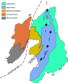
Geological map of Islay
-
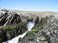
Rocks of the Rhinns complex at Claddach Bay on the southernmost tip of the Rinns

See also
 In Spanish: Islay para niños
