
Loch Indaal facts for kids

 |
|
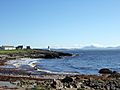
| The lighthouse just outside Port Charlotte on Islay. | |
| Location | Port Charlotte Islay Argyll and Bute Scotland United Kingdom |
|---|---|
| Coordinates | 55°44′41″N 6°22′20″W / 55.744760°N 6.372223°W |
| Year first constructed | 1869 |
| Construction | brick tower |
| Tower shape | ctlindrical tower with balcony and lantern |
| Markings / pattern | white tower, black lantern, ochre trim |
| Height | 13 metres (43 ft) |
| Focal height | 15 metres (49 ft) |
| Characteristic | Fl WR 7s. |
| Admiralty number | A4254 |
| NGA number | 4236 |
| ARLHS number | SCO-198 |
Loch Indaal is a large sea loch on the island of Islay. Islay is the southernmost island of the Hebrides, located off the west coast of Scotland.
This loch was formed by a big crack in the Earth's crust. This crack is called the Loch Gruinart Fault. It is connected to an even bigger fault called the Great Glen Fault.
Many villages are found along the shores of Loch Indaal. On the northwest side are Bruichladdich and Port Charlotte. The small village of Bridgend is on the northeast shore. Bowmore, the main town on Islay, is on the southeast shore.
At night, the lights from these villages shine across the loch. These lights inspired a famous folk song called "The Lights of Lochindaal." It was written by Iain Simpson.
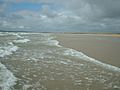
South of Bowmore, there is a long sandy beach. It stretches for six miles all the way to Kintra. This beach is known as the Big Strand. It is very popular with both tourists and local people, especially in the summer.
About the Waters of Loch Indaal
Loch Indaal gently slopes from its northeast end towards the Atlantic Ocean. At the mouth of the loch, it is about 40 meters deep. This mouth is between Portnahaven to the north and the American Monument on The Oa to the south.
The water gets shallower as you go northeast. Between Laggan Point and Port Charlotte, it is only about 10 meters deep. The waters inside the loch are usually calm and safe for boats. However, getting into the loch from the ocean can be tricky. There are strong currents and swirling waters, especially for small boats.
The Big Strand and Laggan Bay
The eastern side of Loch Indaal is home to the Big Strand. This long sandy beach is about six miles long. The whole area around it is known as Laggan Bay. The beach is mostly sand, but there is a rocky part in the middle. This rocky area is near Glenegedale Airport.
You can reach the northern part of the Big Strand by car. There is a dirt road leading from Island Farm. This road is signed off the A846, south of Bowmore. The River Laggan flows into the ocean near the northern end of the beach. In the south, you can get to the Big Strand from Kintra Farm on The Oa.
Glenegedale Airport has two runways. One of them is not currently used. When planes land on the northwest runway, they fly very low over Loch Indaal. This gives passengers amazing views of Laggan Bay below.
Gallery
-
Looking west across the loch to the Rinns at low tide
-
Looking north from Port Charlotte across the loch to Jura
-
The Big Strand
-
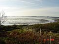
Towards Traigh Cill an Rubha Looking across the head of Loch Indaal in late afternoon
-
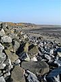
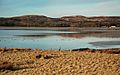
The shore at Gortan, Loch Indaal looking along the edge of the shore at low tide


See also
 In Spanish: Loch Indaal para niños
