
Argyll and Bute facts for kids
Argyll and Bute is a special kind of local area in Scotland, UK. It's one of 32 "council areas" that help manage different parts of Scotland. Think of it like a big county with its own local government. The main office for Argyll and Bute is in a town called Lochgilphead.
This area is very large, actually the second biggest in Scotland! It shares its borders with other council areas like Highland, Perth and Kinross, Stirling, and West Dunbartonshire. Part of its border even goes right through the famous Loch Lomond.
Contents
How Argyll and Bute Was Formed
Argyll and Bute became a council area in its current form in 1996. Before that, Scotland had a different way of organizing its local areas.
Changes in Local Government
From 1975 to 1996, Scotland was divided into larger "regions." Argyll and Bute was part of a big region called Strathclyde. This region had many smaller parts called "districts."
Merging Areas Together
When the new system started in 1996, the old Argyll and Bute district joined up with a small part of another district called Dumbarton. This part was known as the 'Helensburgh and Lomond' ward. A "ward" is like a small voting area.
Helensburgh and Lomond Ward
The Helensburgh and Lomond ward included the town of Helensburgh. It covered an area west of Loch Lomond, north of the Firth of Clyde, and mostly east of Loch Long. This merger helped create the Argyll and Bute we know today.
Images for kids
-
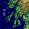
A map showing the area of Argyll and Bute.
-
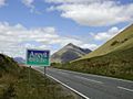
The A82 road, looking north through the beautiful landscape.
-
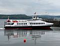
The MV Argyll Flyer ferry at Dunoon pier.
-
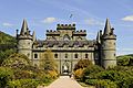
Inveraray Castle, a famous landmark in Argyll and Bute.


See also
 In Spanish: Argyll y Bute para niños
