
Highland (council area) facts for kids
Quick facts for kids
|
|||
|---|---|---|---|
 |
|||
|
|||
| Sovereign state | United Kingdom | ||
| Country | Scotland | ||
| Lieutenancy areas | Inverness, Nairn, Ross and Cromarty, Sutherland, Caithness | ||
| Admin HQ | Inverness | ||
| Government | |||
| • Body | The Highland Council | ||
| Area | |||
| • Total | 9,906 sq mi (25,657 km2) | ||
| Area rank | Ranked 1st | ||
| Population
(2020)
|
|||
| • Total | 235,540 | ||
| • Rank | Ranked 7th | ||
| • Density | 23.7770/sq mi (9.1803/km2) | ||
| ONS code | S12000017 | ||
| ISO 3166 code | GB-HLD | ||

.svg)
Highland (Scottish Gaelic: Gàidhealtachd, Scots: Hieland) is a large area in the north of Scotland. It is one of Scotland's council areas. This means it has its own local government, called The Highland Council. It is the biggest local government area in the whole United Kingdom.
In 2011, Highland was the 7th most populated council area in Scotland. It shares borders with other council areas like Aberdeenshire, Argyll and Bute, Moray, and Perth and Kinross. Even though it's called "Highland," this area does not cover all of the Scottish Highlands. Other parts of the Highlands are in different council areas.
Contents
Understanding the Name "Highland"
The name Highland can be a bit confusing. When people talk about the council area, they often say "the Highland Council Area" or "the Highland area." They don't usually just say "Highland" on its own. For example, saying "Dingwall in Highland" sounds a bit strange. It's more common to say "Dingwall in the Highland Council area."
This is because the name Highland also refers to the much larger geographic area of the Scottish Highlands. The council area is only a part of this bigger region. So, to be clear, people often add "Council area" or "region" when talking about the specific area governed by The Highland Council.
Highland's History and Government
How the Highland Council Area Was Formed
The Highland area was created in 1975. Before that, Scotland had different types of local governments, like counties. The new system set up a main council for the whole Highland region. It also had eight smaller district councils within it.
In 1996, there was another big change. The main Highland Regional Council and all the smaller district councils were replaced. A new single council, called The Highland Council, took over all their jobs.
Changes in Local Management Areas
After 1996, the Highland Council used the old district areas for managing things. They also set up committees for these areas. Over time, these areas changed.
By 2022, the council decided to use eleven different area committees. These committees help manage local services. They include areas like Badenoch and Strathspey, Caithness, and the City of Inverness.
Exploring Highland's Geography
.jpg)
The main office for The Highland Council is in Inverness. This city is the largest settlement in the area.
Size and Population
The Highland council area is very large. It covers about 25,657 square kilometers. This is a huge part of Scotland, making up almost one-third of the country's land. It's even bigger than the country of Wales!
Even though it's so big, Highland doesn't have a very high population density. This means there aren't many people living in each square kilometer. In 2012, there were only about 9 people per square kilometer. This is much lower than the rest of Scotland.
Historically, more people lived in the Highlands. But in the late 1800s, many people moved away from the rural areas. For example, the population of Skye dropped a lot. In recent years, the population has started to grow again.
Key Geographical Features
The highest point in the Highland council area is Ben Nevis. This is the tallest mountain in all of Scotland and the entire United Kingdom.
Highland also contains the northernmost point of Great Britain, which is Dunnet Head. The westernmost point, called Corrachadh Mòr, is also here.
While the name "Highland" suggests mountains, not all of the area is mountainous. Some parts, like the areas east of Inverness and Caithness, are actually low-lying.
Gaelic Language in Highland
The Scottish Gaelic language is an important part of Highland's culture. According to the 2011 UK census, nearly 12,000 people in the Highland area speak Gaelic.
Major Settlements in Highland
The largest towns and cities in the Highland council area are:
| Settlement | Population (2020) |
|---|---|
| Inverness | 47790 |
| Nairn | 10190 |
| Thurso | 7390 |
| Wick | 6870 |
| Alness | 5950 |
| Fort William | 5600 |
| Westhill | 5470 |
| Dingwall | 5360 |
| Invergordon | 3930 |
| Culloden | 3830 |
Images for kids
-
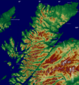
Topographic map of the Highland council area.

See also
 In Spanish: Highland para niños
