Perth and Kinross facts for kids
Quick facts for kids
Perth and Kinross
Pairth an Kinross Peairt agus Ceann Rois |
|||
|---|---|---|---|
 |
|||
|
|||
| Sovereign state | United Kingdom | ||
| Constituent country | Scotland | ||
| Lieutenancy area | Perth and Kinross | ||
| Admin HQ | Perth | ||
| Government | |||
| • Body | Perth & Kinross Council | ||
| Area rank | Ranked | ||
| • Rank | Ranked | ||
| ONS code | S12000048 | ||
| ISO 3166 code | GB-PKN | ||
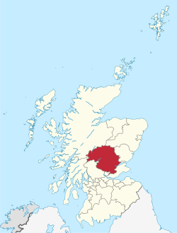
Perth and Kinross (Scots: Pairth an Kinross; Scottish Gaelic: Peairt agus Ceann Rois) is a special area in Scotland. It's one of 32 'council areas' that help manage local services. It is also a lieutenancy area, which is a ceremonial region.
Perth and Kinross shares borders with other areas. To the north, it meets Highland and Aberdeenshire. To the east, you'll find Angus, Dundee, and Fife. Clackmannanshire is to the south, and Stirling and Argyll and Bute are to the west. The main office for the area is in the city of Perth.
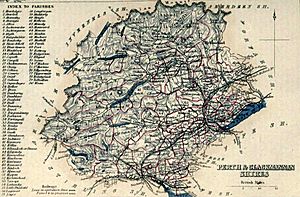
This area includes the historic county of Kinross-shire and part of Perthshire. From 1929 to 1975, Perthshire and Kinross-shire shared a local government. Then, from 1975 to 1996, Perth and Kinross was a district within the Tayside region. In 1996, it became its own 'unitary authority', meaning it manages all its local services.
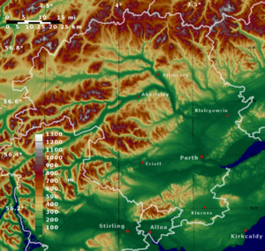
The area is naturally split by a geological line called the Highland Boundary Fault. This fault divides it into a northern part with mountains and a flatter southern part. The mountains in the north are popular for tourists. In the southern part, farming is a very important business.
The area is run by the Perth and Kinross Council. Its representatives in the Scottish Parliament and the Parliament of the United Kingdom are mostly from the Scottish National Party.
Contents
History of Perth and Kinross
Before 1975, Perthshire and Kinross-shire were separate counties. In 1973, a new law changed how local government worked in Scotland. Kinross-shire became part of the Tayside region. Perthshire was split between the Tayside and Central regions.
Later, in 1994, another law dissolved these regions. In 1996, the current area of Perth and Kinross was created. It was formed from the parts of Perthshire and Kinross-shire that used to be in the Tayside region.
Geography and Landscapes
The Highland Boundary Fault is a major geological line that crosses Perth and Kinross. It runs from the northeast to the southwest. This fault roughly divides the area into two main parts.
- Highland Perthshire: To the north of the fault, you'll find mountainous areas. This includes part of the Grampian Mountains. These highlands have many glacial valleys. These valleys often contain long, narrow lakes called ribbon lakes, like Loch Tay and Loch Earn.
- Lowland Perthshire and Kinross: To the south of the fault, the land is flatter and very fertile. This area is part of Scotland's Central Lowlands.
Economy and Industries
The economy of Perth and Kinross has different strengths in its northern and southern parts.
- Southern Perth and Kinross: Farming is a big part of the economy here. Farmers grow fruits, animal feed, wheat, and special seed potatoes.
- Northern Perth and Kinross: This area is very beautiful, so tourism is important. Many people visit to see the stunning scenery. The Forestry Commission manages large forests in this region. There are also several hydroelectric dams that produce electricity from water power.
Towns and Villages
Largest Towns by Population
Here are some of the biggest towns and villages in Perth and Kinross, listed by how many people live there:
| Settlement | Population (2020) |
|---|---|
| Perth | 47350 |
| Blairgowrie and Rattray | 9240 |
| Crieff | 7280 |
| Auchterarder | 5840 |
| Kinross | 5610 |
| Scone | 5030 |
| Bridge of Earn | 2920 |
| Pitlochry | 2880 |
| Alyth | 2370 |
| Coupar Angus | 2220 |
| Milnathort | 1950 |
| Aberfeldy | 1940 |
| Comrie | 1900 |
| Invergowrie | 1750 |
| Luncarty | 1630 |
| Stanley | 1500 |
| Errol | 1490 |
| Inchture | 1420 |
| Abernethy | 1390 |
| Almondbank | 1370 |
Fun Places to Visit
Perth and Kinross has many interesting places to explore, from ancient castles to beautiful natural spots:
- Ashintully Castle
- Atholl Country Life Museum
- Ben Lawers
- Blackhall Roman Camps
- Blair Atholl Mill
- Blair Castle
- Cateran Trail
- Cairngorms National Park
- Castle Menzies
- Clan Donnachaidh Centre
- Cluny House Gardens
- Dirnanean House
- Drummond Castle
- Edradour Distillery
- Elcho Castle
- Forest of Atholl
- Fortingall Yew
- Glen Lyon
- Grampian Mountains
- Kindrogan House
- Lendrick Muir School
- Loch Earn
- Loch Lomond and the Trossachs National Park
- Loch Rannoch
- Loch Tay
- Melville Monument
- Portmoak
- Rannoch Moor
- Strathearn
- Whitefield Castle
See also
 In Spanish: Perth and Kinross para niños
 | Emma Amos |
 | Edward Mitchell Bannister |
 | Larry D. Alexander |
 | Ernie Barnes |


