
Ben Lawers facts for kids
Quick facts for kids Ben Lawers |
|
|---|---|
| Beinn Labhair | |

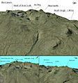
Ben Lawers seen from Beinn Ghlas
|
|
| Highest point | |
| Elevation | 1,214 m (3,983 ft) |
| Prominence | c. 915 m Ranked 11th in British Isles |
| Parent peak | Ben Nevis |
| Listing | Munro, Marilyn, Council top (Perth and Kinross), County top (Perthshire) |
| Naming | |
| English translation | Hill of the loud stream or hoof or claw mountain |
| Language of name | Gaelic |
| Geography | |
| Location | Perth and Kinross, Scotland |
| Parent range | Grampian Mountains |
| OS grid | NN636414 |
| Topo map | OS Landranger 51 |
Ben Lawers (Scottish Gaelic: Beinn Labhair) is a very tall mountain in the southern part of the Scottish Highlands. It stands north of Loch Tay. Ben Lawers is the highest point of a long group of mountains that includes seven Munros. A Munro is a Scottish mountain over 3,000 feet (914.4 metres) high.
This mountain is the highest peak in Perthshire. It is also the tenth highest Munro in all of Scotland. For a long time, people thought Ben Lawers was over 4,000 feet (1,219 metres) tall. But in the 1870s, careful measurements showed it was about 17 feet (5 metres) shorter than that.
Ben Lawers sits on the line where water flows in different directions. This line is called a watershed. Water from its south side flows into the River Tay. Water from its north side flows into Glen Lyon. Since the 1950s, water from many small streams on Ben Lawers has been collected. This water is part of the Breadalbane Hydro-Electric Scheme. This project uses water to make electricity.
The water is sent to a place called Lochan na Lairige. From there, it travels through pipes to power machines. These machines create electricity at Finlarig, near Loch Tay. A large dam, called the Lawers Dam, was built to raise the water level at Lochan na Lairige. This dam is 344 metres long and 42 metres high. Because the reservoir is so high up, the water pressure is very strong. This makes it the most powerful hydro-electric scheme in Scotland.
Because Ben Lawers is so high and has special rocks, it is home to many rare plants. These plants are called arctic-alpine species. They usually grow in very cold, northern places. Ben Lawers has been a special protected area, a National Nature Reserve (NNR), since 1964.
Contents
History of Ben Lawers
The southern slopes of Ben Lawers, above Loch Tay, show many signs of people living there long ago. The soil on these slopes is good for farming. This is because it has fertile limestone and schist rocks. People have farmed here since ancient times. There are many remains from the Bronze Age.
Archaeologists have found many large stones with special carvings. These are called cup and ring marks. Derek Alexander, an archaeologist, said this shows Ben Lawers was a very important place in ancient times.
Old paths climb up the mountain from the valley. These paths lead to places where people used to cut peat for fuel. They also lead to sheilings. Sheilings were small huts used by shepherds in summer. You can still see the ruins of these huts. Each hut often has a few trees around it. There are also signs of old fields where crops were grown.
All these signs show that local people used to visit the mountain tops. They would take their animals to graze high up during the summer. A mapmaker named Timothy Pont visited the area in the 1590s. Some people think he or his helpers climbed Ben Lawers. If so, that would be the first recorded climb.
The first definite recorded climb was on September 17, 1776. This was by a group led by a military surveyor named William Roy. They took measurements from the top of Ben Lawers.
Who Owns Ben Lawers?
Long ago, before the 1300s, the mountain belonged to the Clan MacMillan. Then, in the mid-1300s, the Chalmers family took the land by force. This happened during the time of King David II.
In 1473, King James III took the land from the Chalmers family. He gave it to Sir Colin Campbell of Glenorchy. This was because Thomas Chalmers was involved in the murder of King James I. Most of the land has stayed with the Campbell family of Glenorchy and Breadalbane since then. However, some farms were sold in the late 1940s.
Since 1950, most of the south side of Ben Lawers has been owned by the National Trust for Scotland. This was made possible by a generous gift from Percy Unna. He was a mountaineer and once led the Scottish Mountaineering Club. In 1996, the Trust bought more land, including the nearby Tarmachan range.
The Trust used to have a visitor centre at the west end of the mountain range. It had an exhibit about how the mountain was formed. This centre was closed and taken down in 2010. A new car park has been built across the road. From there, a path leads to the top of Ben Lawers. This path goes over a smaller peak called Beinn Ghlas. There is also a nature trail on the lower part of this path. You can get information leaflets about it at the car park.
The northern side of the Ben Lawers range has three private estates. These are Roroyere, Roromore, and South Chesthill. They all stretch from Glen Lyon to the top of the mountain ridge. In Scotland, people have a right to walk responsibly on most land. This means you can visit the hills, even if they are privately owned. You just need to follow the Scottish Outdoor Access Code.
Nature and Wildlife
| Ben Lawers National Nature Reserve | |
|---|---|
|
IUCN Category II (National Park)
|
|

Ben Lawers National Nature Reserve
Location in Perth and Kinross
|
|
| Location | Perth and Kinross, Scotland |
| Area | 44.4 km2 (17.1 sq mi) |
| Designation | NatureScot |
| Established | 1964 |
| Owner | National Trust for Scotland |
| Ben Lawers National Nature Reserve | |
Experts who study plants, called botanists, think Ben Lawers is one of the best places in the UK for alpine plants. This is because the mountain has special schist rocks at the right height. These rocks give the plants important nutrients like calcium and magnesium. The rocks also break down into a clay-like soil that holds water well.
Some of the rare plants found on Ben Lawers include alpine forget-me-not and roseroot. You can also find net-leaved willow and many types of saxifrage plants. In 2021, efforts were made to save a very rare flower called Sabulina rubella, or Mountain Sandwort, from disappearing.
Animals also find Ben Lawers interesting. Some of the birds you might see include ravens, ring ouzels, and red grouse. You might also spot ptarmigan, golden eagles, and peregrine falcons. Other rare birds like dotterel, golden plover, and short-eared owls live here too. Other rare animals include the viviparous lizard and the wildcat.
The Ben Lawers area has been a National Nature Reserve (NNR) since 1964. In 2005, the protected area was made larger. It now includes all the land owned by the National Trust for Scotland in the area. This includes the Tarmachan range. The Trust manages this reserve for NatureScot.
Ben Lawers is also a Special Area of Conservation (SAC). It is also a Site of Special Scientific Interest (SSSI). These are other ways to protect its special nature. The Ben Lawers National Nature Reserve is a Category II protected area. This means it is managed mainly for protecting ecosystems and recreation.
The Ben Lawers range is part of the Loch Rannoch and Glen Lyon National Scenic Area. This is one of 40 such areas in Scotland. These areas are chosen because they have amazing scenery. They are protected to make sure they stay beautiful.
Climbing Ben Lawers
Ben Lawers is a very popular mountain for hillwalkers. Because so many people visit, the paths can get worn down. This can harm the plants. Since the 1980s, the National Trust for Scotland has been working with other groups. They are trying to fix the paths and control the impact of many visitors.
The easiest way to climb Ben Lawers starts from the National Trust car park. A clear path leads to the top. It goes over a smaller peak called Beinn Ghlas first.
There are other ways to climb the mountain if you want to avoid the busiest path. These routes often start by following Lawers Burn. This burn meets the A827 road near the village of Lawers. If you head north from this burn, you can climb other peaks to the northeast of Ben Lawers. The most direct way to the top from Lawers village is to follow Lawers Burn to Lochan nan Cat. This means "lochan of the cat." From there, you can go straight up to the summit along the east ridge.
Images for kids
-
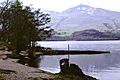
Ben Lawers seen from Loch Tay
-
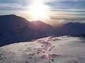
Ben Lawers in winter
-
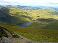
Lochan Nan Cat from the summit of Ben Lawers
-
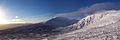
Ben Lawers and Meall Garbh
-
Ben Lawers 3D map


See also
 In Spanish: Ben Lawers para niños
