
Grampian Mountains facts for kids
_Named_(HR).png)
The Grampian Mountains (called Am Monadh in Scottish Gaelic) are one of the three main mountain ranges in Scotland. Together, these ranges cover about half of Scotland. The other two are the Northwest Highlands and the Southern Uplands. The Grampians stretch from the southwest to the northeast. They are located between two important geological lines: the Highland Boundary Fault and the Great Glen.
This mountain range is home to many of the highest mountains in the British Isles. These include Ben Nevis, which is the tallest at 1,345 meters (4,413 feet) above sea level. Ben Macdui is the second highest, reaching 1,309 meters (4,295 feet).
Many rivers and streams start in the Grampians. Some of these include the Tay, Spey, Don, and Dee. The area is not very crowded, meaning few people live there.
People sometimes disagree about exactly how big the Grampian Mountains are. Before the 1800s, people often thought of them as several smaller ranges. These smaller ranges were all part of the larger Scottish Highlands. Even today, many people still see them this way. There isn't one single name for them in the Scottish Gaelic language or in the Doric dialect of Lowland Scots. Instead, different names are used. The name "Grampian" has been used for groups and areas in Scotland north of the Central Belt. Examples include the old local government area called Grampian Region and NHS Grampian, which is a health board.
Contents
What's in a Name?

The Roman historian Tacitus wrote about a place called Mons Graupius. This was where the native Caledonians were defeated by the Roman general Gnaeus Julius Agricola around 83 AD. Historians still debate the exact spot of Mons Graupius, which means 'Mount Graupius'. Most think it was somewhere within the Grampian mountains. It might have been at places like Raedykes or Megray Hill.
The spelling Graupius comes from an old copy of Tacitus's book, made around the mid-800s. In the Middle Ages, this area was known as the Mounth. This name is still used for some places today.
How Did the Name "Grampians" Come About?
The name Grampians first appeared as Graupius in 83 AD. Its exact origin is not fully known. It might come from an old British word, *Cripius, which meant "ridge." This is similar to the Welsh word crib, also meaning ridge.
However, the name "Graupius" was accidentally changed to "Grampius" in a printed book in 1476. The Scottish historian Hector Boece is thought to have first used the name Grampians for the mountain range in 1520. He might have adapted it from the incorrect "Mons Grampius." So, it's possible that the Grampian Mountains got their name because of a simple mistake by someone printing a book long ago!
How Big Are the Grampians?
The exact size of the Grampian Mountains can be a bit confusing. Some people have different ideas about where they start and end. For example, Fenton Wyness, who wrote about the Dee Valley in 1968, said the northern edge of the Grampians was at the River Dee. He described them as a range of mountains starting south of Aberdeen and going west. This included peaks like Mount Keen and Lochnagar.
Another scientist, Adam Watson, also talked about the Grampians. When he described the Cairngorms, he said they were separate from the mountains south of the River Dee. He noted that many maps and books called these southern mountains 'the Grampians'. However, he also said that local people didn't use that name.
Both Wyness and Watson seemed to think the Cairngorms were a separate mountain range, not part of the Grampians. In their view, the Grampians were more like the Mounth. But Robert Gordon, writing in the 1650s, used the term Grampians for hills on both sides of the River Dee. This means he included the Cairngorms within the Grampian range.
Some definitions of the Grampians are even wider. The 1911 Encyclopedia Britannica, for example, included the highlands as far west as Dunbartonshire. This shows that there isn't one single, agreed-upon boundary for the Grampian Mountains.
What Are the Grampians Made Of?
The Grampian Mountains are mostly made of two types of rocks: metamorphic and igneous rocks. Metamorphic rocks are rocks that have changed due to heat and pressure. Igneous rocks are formed from cooled magma or lava.
You can find rocks like granite, gneiss, marble, schists, and quartzite in the mountains.
A long time ago, less than 2.6 million years ago, huge glaciers covered this area. These glaciers carved out the landscape and changed it a lot. The deposits left behind by the glaciers, like tills, are mostly from the last Ice Age, which ended less than 20,000 years ago.
Smaller Mountain Groups Within the Grampians
The Grampians are a large area, and within them, there are several smaller groups of hills and mountains. These are generally considered part of the Grampians because they lie between the Highland and Great Glen fault lines.
Some of these smaller mountain groups include:
- Cairngorms
- Monadh Liath
- Mounth
- Grey Corries
- Mamores
- Ben Alder Forest
- The mountains of Glen Coe and Glen Etive
- Black Mount
- Breadalbane Hills
- Trossachs
- Arrochar Alps
- Cowal
- The Isle of Arran
Grampians in Stories
The Grampian Hills are mentioned in a famous play from 1756 called Douglas. A character named Norval starts the second act with a well-known speech:
My name is Norval; on the Grampian Hills My father feeds his flocks; a frugal swain, Whose constant cares were to increase his store. And keep his only son, myself, at home.
This speech became very popular on its own. People would recite it, learn it in school, and it was widely known in the 1700s and 1800s. Famous writers like Jane Austen, Charles Dickens, and George Bernard Shaw even referred to it in their works.
Images for kids
-
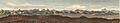
View of the Grampian Mountains, 1831
See also
 In Spanish: Montes Grampianos para niños
