
Isle of Arran facts for kids
| Norse name | Herreyp38 |
|---|---|
| Meaning of name | Possibly Brythonic for "high place" |
| OS grid reference | NR950359 |
| Physical geography | |
| Island group | Firth of Clyde |
| Area | 43,201 hectares (167 sq mi) |
| Area rank | 7 p502 |
| Highest elevation | Goat Fell 874 m (2,867 ft) |
| Administration | |
| Sovereign state | United Kingdom |
| Country | Scotland |
| Council area | North Ayrshire |
| Demographics | |
| Population | 5,058 |
| Population density | 11.68 people/km2p11 |
| Largest settlement | Brodick |


Arran, also known as the Isle of Arran, is a beautiful island in Scotland. It is the largest island in the Firth of Clyde. Arran is sometimes called "Scotland in miniature." This is because it has both rugged mountains and flatter lowlands, just like mainland Scotland.
Arran covers about 432 square kilometers (167 square miles). This makes it the seventh largest island in Scotland. Around 5,000 people call Arran home. The island is famous for its stunning mountains and interesting rocks. Many geologists love to visit Arran.
People have lived on Arran for a very long time. We know this from ancient remains found there. These remains date back to the early Neolithic period. Later, people from Ireland settled on the island. Arran became an important religious center. During the Viking Age, the island was ruled by Norway. But in the 1200s, it became part of the Kingdom of Scotland.
In the 1800s, many people left Arran. This was due to something called the "clearances." This period caused the Gaelic language and traditional way of life to disappear. Today, Arran's economy is growing again. Tourism is the main industry. The island also has unique wildlife. This includes three types of trees found only there. Students often visit to study its geology and biology.
Contents
Exploring Arran's Geology
Arran is often called a "geologist's paradise." This is because it shows many different types of rocks and landforms. The island is split into two main parts. The northern part is mountainous, like the Scottish Highlands. The southern part is flatter, like the Scottish Lowlands. A special line called the Highland Boundary Fault separates these two areas.
Geologists love to study the rocks on Arran. They can see igneous rocks, which form from cooled magma. These include sills and dykes. They also find sedimentary rocks. These rocks formed from layers of sand, mud, or other materials. The rocks on Arran range from very old (Precambrian) to much younger (Mesozoic).
Most of the northern mountains are made of granite. This granite formed about 60 million years ago. It was created by huge volcanic activity. The southern part of Arran has many sedimentary rocks. These include Old Red Sandstone and New Red Sandstone. You can even find ancient sand dunes preserved in rocks near Brodick. Some parts of the island also have Cretaceous chalk.
James Hutton's Discovery
In 1787, a famous geologist named James Hutton visited Arran. He found something special near Lochranza. It was a place where two very different rock layers met. This meeting point is called an unconformity. It showed that the Earth's surface changes slowly over long periods. This discovery helped Hutton understand how old the Earth really is. This spot is now one of the most famous places for geology students.
Ice Age and Coastlines
Long ago, during the Pleistocene Ice Age, Scotland was covered in thick ice. When the ice melted, sea levels were much lower. About 14,000 years ago, Arran might have been connected to mainland Scotland.
As the ice melted, the land slowly rose up. This is because the heavy ice had pushed the Earth's crust down. As the land rose, old beaches were lifted higher than the current sea level. These are called raised beaches. You can see these old beaches all around Arran.
King's Cave, on the southwest coast, is a great example. This cave is over 30 meters (100 feet) long and 15 meters (50 feet) high. It sits far above today's sea level. This shows how much the land has risen.
Arran also has tall sea cliffs in the northeast. Some parts of these cliffs have seen huge rock slides. One famous slide at Scriden happened about 200 years ago. It was so big that people heard it on other islands!
Wildlife and Nature
Arran is home to a variety of plants and animals. The island's diverse landscapes support many different species. You can find many types of birds, insects, and marine life around its coasts.
One special feature of Arran's wildlife is its unique trees. There are three types of trees that grow only on Arran. These are called endemic species. They are very important for the island's natural heritage. Students often visit Arran to study these special plants and the island's other wildlife.
Tourism and Economy
Tourism is very important to Arran's economy. Many visitors come to the island each year. They come to enjoy the beautiful scenery, go hiking, and explore the ancient sites. The main town, Brodick, is a popular spot for tourists. It has shops, restaurants, and a castle.
Visitors can take ferries to Arran from the mainland. The island offers many outdoor activities. These include walking, cycling, and wildlife watching. The stunning landscapes and rich history make Arran a popular holiday destination.
Images for kids
-
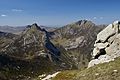
Cìr Mhòr and Caisteal Abhail seen from North Goatfell
-
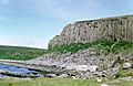
Cliffs at Blackwaterfoot
-
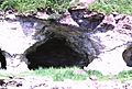
The "King's Cave", a famous cave on Arran
-
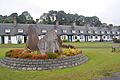
"Hamilton Terrace" with the Clearances Monument, Lamlash
-
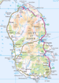
Map of Arran. The island to the east is Holy Island and the tiny island to the south is Pladda.
-
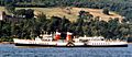
PS Waverley in front of Brodick Castle
-

The Brewery logo
-
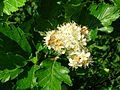
Sorbus arranensis in flower at Eglinton Country Park, Irvine.


See also
 In Spanish: Isla de Arran para niños
