
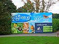
Eglinton Country Park facts for kids


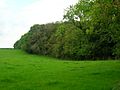
Eglinton Country Park is a large park in Kilwinning, North Ayrshire, Scotland. It covers about 400 hectares (that's like 988 football fields!) and includes woodlands. The most famous part of the park is the ruined Eglinton Castle. This castle was once the home of the Eglinton family and later the Montgomeries, who were important leaders of the Clan Montgomery. Today, North Ayrshire Council looks after Eglinton Country Park and its Ranger Service helps keep it beautiful and safe for everyone.
Contents
- Exploring Eglinton Country Park
- Wildlife in the Park
- The History of Eglinton Country Park
- The Earls of Eglinton and the Clan Montgomery
- The Decline and Rebirth of Eglinton
- Discovering the Past: Archaeology
- Scottish Wildlife Trust Reserves
- Benslie and Fergushill
- The Robert Burns Connection
- The Scottish Campsite at Knadgerhill
- The Eglinton Geocaches
- The Eglinton Wildlife Site
- The 1774 Irvine - Kilwinning Toll Road
- Interesting Facts About Eglinton
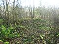
Exploring Eglinton Country Park
Spier's Parklands

The Spier's Old School Grounds are another great place to visit, located near Beith. You can walk around them any time, day or night. The park rangers also patrol these grounds. A group called "Friends of Spiers" helps to improve and look after the area. Spier's has paths that are easy for wheelchairs and other routes covered with bark chips. Many events are held here throughout the year.
Stevenston Beach and Ardeer Quarry

These areas are important for wildlife and are always open to the public. The park rangers regularly patrol them and work with volunteers to help protect nature. The Stevenston sand dunes are a special nature reserve, and efforts are made to keep them healthy for the plants and animals that live there.
Fun Activities in the Park
Eglinton Country Park has lots of things to do! There are two play parks for children and shelters in case it rains. You can even rent the Rackets Hall for parties, meetings, or other events. There's also a soft play area inside the Rackets Hall that you can hire.
Horse Riding Paths
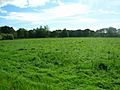
The park has many paths for horse riding, stretching about 11 kilometers (almost 7 miles). About 5 kilometers of these paths are shared, meaning horse riders need to be careful and give way to walkers and cyclists. The paths wind through pretty fields and woodlands.
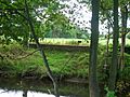
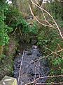
Eglinton Loch and Lugton Water

The Lugton Water river flows through the park. Long ago, several small dams (weirs) were built to make the water deeper and more beautiful. Some mills used to get their power from the Lugton Water.
The large lake, Eglinton Loch, was created in 1975 when materials were dug up for building a new road. This area was once known for flooding and was even the site of jousting matches during the famous Eglinton Tournament in 1839. Today, the loch is full of fish, making it a popular spot for fishing and watching birds.
The Irvine New Town Trail
The Irvine New Town Trail is a long path, about 19 kilometers (12 miles), that's great for jogging, walking, dog walking, and cycling. It forms a big loop, so there's no real start or end. The trail goes through different parts of Irvine and Kilwinning, including Eglinton Country Park.
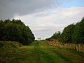
Belvedere Hill and Walking Areas
'Belvedere Hill' means 'beautiful view,' and it's easy to see why! This area has special woodlands with paths that spread out from a central point, offering great views. This design is a restoration of how the area looked around the castle in the 1750s. There are many other footpaths in the park, some of which are just for walkers.
- Views within Eglinton Country Park
-
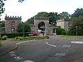
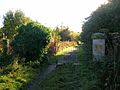
The sign at the main entrance
-
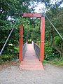
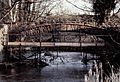
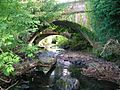
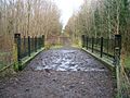
The suspension bridge over the Lugton Water
-
The Belvedere Hill woodlands


Wildlife in the Park
Birds
Many different birds live and breed in the park, including robins, finches, pheasants, and owls. You might also spot buzzards, kestrels, and woodpeckers. In winter, birds like fieldfares and redwings visit. You can also see ducks, swans, and geese on the loch. Sometimes, rare birds like cuckoos or even a flamingo have been spotted!
Mammals
If you are quiet and patient, you might see hedgehogs, foxes, moles, otters, bats, mink, and roe deer in the park.
Other Wildlife
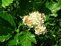
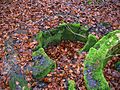
Surveys show that the park has many types of mushrooms and fungi. It also has interesting plant growths called 'galls,' like knopper galls on acorns.
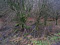
The 'Old Wood' is very old and has many different plants, like bluebells and honeysuckle. Snowdrops are beautiful in spring. Some very old trees, like sycamores, still stand from the estate's past. The park is also one of the few places in Scotland where the rare upright hedge bedstraw grows.
Helping Rare Species
The park helps protect three very rare types of trees called Arran whitebeams. These trees are only found on the Isle of Arran and nowhere else in the world! Chapelholms Wood is a special wildlife site because of its amazing habitats and many different species.
-
Sorbus arranensis (an Arran whitebeam) in flower
-
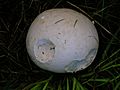
A giant puff-ball mushroom near the castle
-
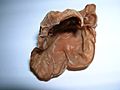
The jelly ear mushroom
-
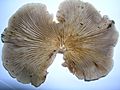
The oyster mushroom


The History of Eglinton Country Park
The Castle, Gardens, and Estate
The Castle

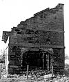
The first Eglinton Castle was burned down in 1528 by a rival family, the Cunninghames, but it was rebuilt. The castle you see in ruins today was finished in 1802. It was a very grand building, known as the most important Georgian castle in Ayrshire.

One part of the 1802 castle was called "Bedlam" by the servants because that's where the children's rooms were! The main hall inside was huge, about 36 feet wide and 100 feet tall. The castle was un-roofed in 1929 because it was in bad condition after its contents were sold.
During World War II, the castle was used for army training, and some parts were damaged. More damage happened in the 1950s, and most of the remaining parts were taken down in 1973, leaving it as you see it today. People used to say the castle had 365 windows, one for each day of the year!
The Park and Gardens

During World War II, the park was used as a training camp and for fixing army vehicles. You can still see some signs of this time, like old Nissen huts and foundations of wartime buildings. The army left the estate in a very messy state with abandoned vehicles.
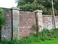
The beautiful gardens were designed by John Tweedie and planted for the 10th Earl. The Earl was very interested in farming. The gardens were finished by 1801. At its biggest, the estate covered about 1346 acres, with lots of grassy areas, woodlands, and gardens. A tall stone wall surrounded much of the park, which had long carriage drives. Many gates and lodges were located around the park.

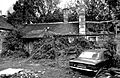
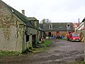
The old estate offices, coach house, and stables were built in the 18th century. This building was later turned into a factory in 1958. Now, it's being changed into homes. There was also a bowling green, said to be the best in Britain, and a tennis court. A deer park surrounded the castle, with many old trees and even a special deer shelter.
The old Walled Kitchen Garden still has its walls and two roofless buildings called 'gazebos' or 'temples.' One was a resting place, and the other was an aviary (for birds). The park's trees were mostly beech, oak, and elm. A hedge maze used to be in the gardens until the 1920s.
Captain Moreton's Eglinton Castle Croquet

Eglinton Castle is famous for an early version of croquet! In the 1860s, a booklet about "The Game of Croquet" was published for the owner of Eglinton Castle. It even had a picture of the castle with a croquet game happening.

The 13th Earl created his own version of croquet called 'Captain Moreton's Eglinton Castle Croquet.' It had special hoops with small bells and tunnels for the ball. This makes it one of the earliest and most unique croquet games known!
- Views of the old walled gardens and temples
-
Part of the old walled 'Kitchen Garden'
-
An old entrance to the walled kitchen gardens
-
The site of the old 'Formal Gardens'
-
Surviving walls from the old 'Formal Gardens'


The Rackets Hall
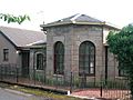
The Rackets Hall at Eglinton is a very special building. It was built shortly after 1839 and is the oldest surviving indoor sports building in Scotland, and the oldest covered racquet court in the world! The floor was made of large granite slabs. It has been restored and is now used as an exhibition area.
Lady Jane's Cottage Ornée

Lady Jane Hamilton, the 13th Earl's aunt, had a beautiful thatched cottage called a 'cottage ornée' by the Lugton Water. She used it to teach local girls about running a home. Nothing remains of this cottage today, but old maps show where it was. There's a local story that Lady Jane was sent to this cottage as a punishment!
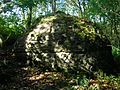
The Old Wood Ice House

An ice house is a special building used to store ice or snow, usually underground. The one in Old Wood was built by the 10th Earl for £25. It had three doors to keep the heat out. During winter, ice and snow were collected from the fishpond or even brought in from Ardrossan Harbour if the winter was too mild.

- Views of the Doocots and Old Wood Ice house
-
The Eglinton mains doocot before restoration
-
The doocot at the Tournament cafe courtyard
-
The ice house in the Old Woods
-
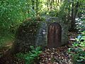
The ice house entrance


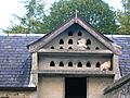
The Doocots

A large, fancy doocot (a building for pigeons) is located near the old Eglinton Mains farm. It's said that some of its stones came from Kilwinning Abbey. Doocots were used to raise pigeons for food. A smaller doocot is part of the stable buildings.
Curling Ponds
Old maps show that the estate had several curling ponds. Curling is a sport played on ice. One set of three ponds was near Weirston House. A painting from the time shows a game being played there. These ponds were fed by a burn, and there was even a curling house where players could get food and drinks.
Cricket Ground and Pavilion
From 1911, maps show a cricket ground and a large pavilion built by the 16th Earl. Two English cricket players were hired to teach the game. Neither the cricket ground nor the pavilion exist today, but part of the area is now used for caravans.
Redburn House
This house was a 'dower house,' meaning it was often used by the widow of an Earl. It had beautiful gardens. Archibald, the 17th Earl, was born here. It was a hotel for some years before being taken down to build new houses.
Kidsneuk Cottage
Lady Susanna Montgomerie, wife of the 9th Earl, had a special cottage built for her at Kidsneuk. It was a copy of the famous 'Hameau de la Reine' that Marie Antoinette had at Versailles. This building is now a golf clubhouse.
The Cadgers' Racecourse
Every August, Irvine holds its Marymass Festival, which includes horse racing on the Cadgers racecourse. A 'cadger' was someone who transported goods on horseback long ago. Later, a new racecourse was built nearby for thoroughbred horses, where the Scottish Grand National used to be held.
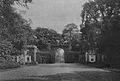
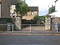
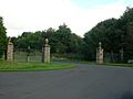
- Eglinton's gates and gatehouses
-
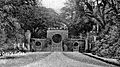
Stanecastle Gate around 1840
-
The Stanecastle gate in 2007
-
Redburn gate around 1910
-
The old Girdle gate
-
The gates on the Kilwinning Road
-
The Kilwinning gatehouse
-
The Mid gate lodge
-
Millburn Lodge and gate
-
The restored Belvedere gates
-
Chapelholm Gate
-
The ruins of Corsehill Lodge
-
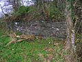
The old well at the Draughtburn Gate


The Earls of Eglinton and the Clan Montgomery

The Montgomerie family became the owners of Eglinton through marriage in the late 1300s. They were involved in many historical events, including a long-running feud with the Cunninghames family. In 1488, the Montgomeries burned down the Cunninghames' Kerelaw Castle. This feud continued for many years, with battles and even murders, until King James VI helped them make peace.
The current Earl is Archibald George Montgomerie, the 18th Earl of Eglinton. The family moved to Perthshire in 1995.
The Eglinton Tournament

Eglinton is most famous for a grand, but unlucky, medieval tournament organized by the 13th Earl in 1839. He wanted to recreate a medieval jousting event. People came from all over, and even the future Napoleon III of France was there! However, heavy rain ruined much of the fun. The jousting took place at what is now Eglinton Loch.

Friends gave the 13th Earl a beautiful silver trophy to remember the event. This trophy is now kept by North Ayrshire Council. The tournament cost a lot of money, about £40,000, which was a huge amount back then. This, along with other financial problems, led to the family's fortune declining.
The Decline and Rebirth of Eglinton
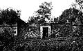
The Montgomerie family faced money problems, and in 1925, they sold everything inside the castle. The castle was then un-roofed and its windows removed so they wouldn't have to pay taxes on it. The family moved to Skelmorlie Castle.
In 1939, parts of the estate were bought by the War Department for training. After World War II, much of the remaining estate was sold. New roads and housing developments were built on parts of the land.
The Rebirth
Luckily, the old Irvine Development Corporation and North Ayrshire Council helped save much of the estate by creating Eglinton Country Park. It was officially opened in 1986.
The Wilson family bought the old offices and castle ruins in 1950. Clement Wilson, who owned a food processing factory, opened parts of the grounds to the public. He spent a lot of money fixing up the castle ruins, planting trees, making paths, and restoring the Tournament Bridge. The Wilson family then gave the park to the local council in 1978, which led to the creation of Eglinton Country Park. Today, over 250,000 people visit the park each year!
- Views of the old Eglinton stables and Auchenwinsey Farm
-
The old stables before conversion
-
The stables before redevelopment
-
The courtyard undergoing initial restoration
-
The Diamond Bridge undergoing restoration
-
Auchenwinsey old farm in 2008
-
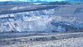
The Sourlie Open Cast coal mine


Discovering the Past: Archaeology
Prehistoric Sites and Finds
Archaeologists have found interesting things from long ago at Eglinton. A small pot (urn) was found near the castle, and a stone axe-hammer was found between the stables and offices. These finds tell us that people lived in this area thousands of years ago.
Old Chapels
Before the Reformation, there might have been three chapels in the area. One was near Chapelholm, another at Weirston, and a third at Stanecastle gate. The foundations of the Stanecastle chapel were found when digging drains, suggesting it was a large building.
Industrial History
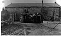
The park area once had a complex network of mineral railway lines, used to transport coal and other materials. You can still see parts of these old railway paths today. A rare bridge for a horse-drawn railway still stands near South Fergushill farm. There were also many coal mines and fire-clay works in the area, but very little remains of them above ground.

The workshops at the Visitor Centre were once an electricity power station, providing power to the castle and other estate houses.
- Old railways around Eglinton
-
The 19th-century waggonway bridge
-
A section of old railway trackbed
-
A loading dock onto an old siding


Lady Ha' Colliery

Ladyha No. 2 coal pit was dug in 1885 and closed in 1934. A brick-lined tunnel still exists that once carried a railway line to the colliery, keeping the smoke away from the castle gardens. This tunnel was even used as a bomb shelter during World War II and is still in good condition.
Scottish Wildlife Trust Reserves
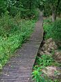
Three areas within the old Eglinton estate are now nature reserves, managed by the Scottish Wildlife Trust. You can visit them for free.
Lawthorn woods has easy access with a raised boardwalk. Corsehillmuir plantation is another woodland reserve. This area was once where witches and criminals were burned at the stake.
- Sourlie, Lawthorn and Corsehillmuir nature reserves
-
The woodland nature reserve at Lawthorn
-
The boardwalk in the nature reserve at Lawthorn
-
Cairnmount Hill, a modern folly
-
Lawthorn mount; a Justice Hill


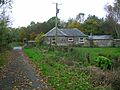
Benslie and Fergushill

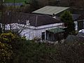
The small village of Benslie is next to a wood that was once part of a 'Baroque garden.' Fergushill church in Benslie was built in 1879 to serve the local communities. Fergushill Cottage, now mostly ruins, was once home to a Mrs. Miller, who remembered collecting water from a nearby well.
- Views of Benslie and Fergushill
-
The Fergushill Burn
-
The old well in the woods
-
The ruins of Fergushill Cottage
-
The ruins of Fergushill Cottage and gardens


The Robert Burns Connection

The famous Scottish poet Robbie Burns once wrote about spending a Sunday in Eglinton Woods. The Drukken or Drucken Steps near Stanecastle was a favorite spot of Burns when he lived in Irvine. A special stone cairn marks the area, though the original steps were part of an old toll road. This road ran through the Eglinton estate and is where Robert Burns and his friend Richard Brown walked.
The Scottish Campsite at Knadgerhill

In 1297, Edward I sent an army to Irvine to stop an uprising. The Scottish army, led by Robert Bruce, decided to surrender. This event led to the signing of the 'Treaty of Irvine.' A memorial at Knadgerhill remembers this historical event.
The Eglinton Geocaches
To encourage people to explore the park, several geocaches have been hidden around the area. Geocaching is a fun outdoor treasure hunt using GPS coordinates.
The Eglinton Wildlife Site
The Scottish Wildlife Trust has named part of the park a 'Wildlife Site.' This area, covering 47 hectares, includes Chapelholms Woods and the wetlands around Eglinton Loch. It's a great place to see different plants and animals.
The 1774 Irvine - Kilwinning Toll Road
- Views of the old Toll Road
-
Ruins at the Draughtburn Gate
-
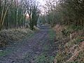
The course of the toll road
-
The old toll road bridge at the Millburn
-
The approach to the old Millburn bridge


The old Toll Road ran from Irvine through the Eglinton estate to Kilwinning. The Drucken Steps were stepping stones on this road. The Draughtburn Gate was built to control who could use this road. You can still follow parts of the road today.
Interesting Facts About Eglinton

- The Montgomeries, who owned Eglinton, also had a town house in Irvine called Seagate Castle.
- A mountain and a river in New Zealand were named 'Eglinton' after the 13th Earl of Eglinton.
- The Glasgow, Paisley and Ardrossan Canal was never fully finished. The Glasgow end was called Port Eglinton.
- A loch was planned in 1807 where the current loch is, connected to the river.
- Rumors say there's a secret tunnel from Kilwinning Abbey to Eglinton Castle, but there's no proof.
- Three ghosts are said to be in the castle: a white lady, a grey lady, and a ghost seen in the tower in 1997.
- The 'gem ring' on the Ardrossan Academy badge comes from the Eglinton family's coat of arms, as the Earl was one of the school's founders.
- Another Eglinton Park exists in Toronto, Canada.
- A gardener once found a skeleton hand in a secret room in the castle after the roof was removed in 1925.
- A 'castle' folly (a decorative building) has been built on a roundabout near the park to remember the Eglinton Tournament.
- A special machine called a 'grubber' or 'rooter' was used to remove old estate trees and create new pasture land. It has been restored and is now on display.
- The Head gardener at Eglinton Castle helped design the gardens at Spier's School in Beith in 1887.
- HMS Eglinton was the name of two warships, a minesweeper and a destroyer, named after the Eglinton Foxhunt.
- At the coronation of Charles I, the Earl of Eglinton had the honor of carrying the king's spurs.
- Glasgow University's Eglinton Arts Fellowship was created in 1862 to honor the 13th Earl.


