
Highland Boundary Fault facts for kids
The Highland Boundary Fault is a huge crack in the Earth's crust that stretches across Scotland. It runs from the Isle of Arran and Helensburgh on the west coast all the way to Stonehaven in the east. This important fault divides Scotland into two very different areas: the rugged Highlands and the flatter Lowlands.
Scotland's amazing geological story is shaped by two massive events. First, a supercontinent called Pangaea formed. Later, Pangaea broke apart, creating the continents we see today. The Highland Boundary Fault played a big role in these changes.
This fault is one of three major cracks that cut across Scotland from southwest to northeast. To the north, there's the Great Glen Fault. To the south, you'll find the Southern Uplands Fault. Just south of Scotland, near England, is the Iapetus Suture. This marks where an ancient ocean, the Iapetus Ocean, once closed up. These four big geological features tell us a lot about Scotland's ancient past.
Contents
What is a Geological Fault?
A geological fault is like a giant crack in the Earth's outer layer, called the crust. These cracks form when the huge plates that make up the Earth's surface move and rub against each other. This movement can cause earthquakes and create mountains or valleys.
How the Fault Formed


The Highland Boundary Fault became active during a period called the Caledonian orogeny. This was a time of massive plate movement and collisions. It happened between 520 and 400 million years ago.
During this time, the ancient Iapetus Ocean was closing. As the landmasses crashed together, the fault allowed the area now known as the Midland Valley to drop down. It sank by as much as 4,000 meters!
At first, the movement along the fault was mostly up and down. Later, it changed to a side-to-side sliding motion. Another important fault, the Southern Uplands Fault, forms the southern edge of Scotland's Central Lowlands.
Landscapes Shaped by the Fault

The Highland Boundary Fault has created some amazing landscapes. For example, the Reekie Linn waterfall is found right on the fault line. Here, hard metamorphic rocks from the Highlands meet softer sedimentary rocks from the Lowlands.
Metamorphic rocks are rocks that have been changed by intense heat and pressure deep inside the Earth. Sedimentary rocks are formed from layers of sand, mud, and other materials that build up over time. The difference in rock hardness helps create the waterfall.
Earthquakes in Comrie

The town of Comrie, located right on the Highland Boundary Fault, is famous for its small earthquakes. Because of these tremors, it's even nicknamed "Shaky Town."
People in Comrie have been interested in earthquakes for a long time. In 1840, the world's first seismometer was set up there. A seismometer is a special tool that measures and records ground movements caused by earthquakes. The building that housed this important instrument was built in 1869.
Images for kids
-
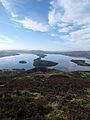
View along the Highland Boundary Fault from Conic Hill – the topographic ridge is mainly due to the presence of Devonian age conglomerates on the southwestern side of the fault and can be traced across Loch Lomond on the islands of Inchcailloch, Torrinch, Creinch and Inchmurrin, to Ben Bowie on the western shore
-
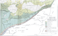
Map published in 1912 by George Barrow showing what became known as the Highland Boundary Fault
-
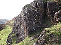
Altered serpentinite and associated sediments of the Highland Border Complex caught up in the fault zone – exposed on Druim nam Buraich, near Balmaha
-
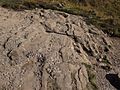
Lower Devonian sandstones and conglomerates of the Inchmurrin Member dipping steeply to the southeast close to the Highland Boundary Fault trace near Balmaha


See also
 In Spanish: Falla de las Highlands para niños
