Great Glen facts for kids

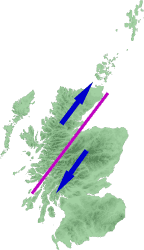
The Great Glen (Scottish Gaelic: An Gleann Mòr) is a long, narrow valley in Scotland. It's also known as Glen Albyn or Glen More. These names come from Scottish Gaelic words meaning "Glen of Scotland" or "Big Valley." The Great Glen stretches for about 62 miles (100 kilometers). It runs from Inverness in the northeast to Fort William in the southwest.
This valley follows a huge crack in the Earth's crust called the Great Glen Fault. This fault line divides the Scottish Highlands into two main parts. To the southeast are the Grampian Mountains. To the northwest are the Northwest Highlands.
A Natural Travel Route
The Great Glen has always been an important travel path in the Scottish Highlands. Today, it's used by the Caledonian Canal and the A82 road. These connect Inverness on the northeast coast with Fort William on the west coast.
A railway called the Invergarry and Fort Augustus Railway was built here in 1896. It ran from the south end of the glen to the south end of Loch Ness. However, it was never extended all the way to Inverness and closed in 1947.
In 2002, the Great Glen Way was opened. This is a long path for cyclists, canoeists, and walkers. It uses footpaths, forest tracks, canal paths, and some roads. It links Fort William to Inverness, making it a great way to explore the area.
Important Forts
The Great Glen was very important for controlling the Highland Scottish clans. This was especially true around the time of the Jacobite risings in the 1700s. To keep control, several forts were built along the glen:
- Fort William is at the southern end.
- Fort Augustus is in the middle of the glen.
- Fort George is just northeast of Inverness.
Lochs and Rivers
Much of the Great Glen is filled with a series of lochs (lakes). Rivers connect these lochs. The Caledonian Canal also uses these lochs as part of its route. However, the rivers themselves are not deep enough for boats.
From northeast to southwest, the main water features in the Great Glen are:
- River Ness (Abhainn Nis)
- Loch Dochfour (Loch Dabhach Phuir)
- Loch Ness (Loch Nis)
- River Oich (Abhainn Omhaich)
- Loch Oich (Loch Omhaich)
- Loch Lochy (Loch Lochaidh)
- River Lochy (Abhainn Lochaidh)
- Loch Linnhe (An Linne Dhubh)
The highest point where water divides and flows in different directions is between Loch Oich and Loch Lochy. This is called a watershed. Loch Linnhe, south of Fort William, is a sea loch. This means it's connected to the ocean. Both the River Lochy and the Caledonian Canal flow into it. At the north end, the River Ness flows into the Beauly Firth, which then meets the Moray Firth.
Earthquakes in the Glen
Even though earthquakes near the Great Glen Fault are usually small, engineers still need to think about them. For example, the Kessock Bridge was built with special features to handle any shaking from earthquakes.
See also
 In Spanish: Great Glen para niños
 | May Edward Chinn |
 | Rebecca Cole |
 | Alexa Canady |
 | Dorothy Lavinia Brown |


