
Fort William, Scotland facts for kids
Quick facts for kids Fort William
|
|
|---|---|
| Town | |
 Fort William Settlement |
|

Fort William
|
|
| Population | 15,757 (2020) |
| OS grid reference | NN 10584 74114 |
| • Edinburgh | 134 mi (216 km) |
| • London | 512 mi (824 km) |
| Council area | |
| Country | Scotland |
| Sovereign state | United Kingdom |
| Post town | FORT WILLIAM |
| Postcode district | PH33 |
| Dialling code | 01397 |
| Police | Northern |
| Fire | Highlands and Islands |
| Ambulance | Scottish |
| EU Parliament | Scotland |
| UK Parliament |
|
| Scottish Parliament | |
Fort William is a town in the Lochaber area of the Scottish Highlands. It sits on the eastern shore of Loch Linnhe in Scotland. Its Gaelic name is An Gearasdan, meaning "The Garrison".
In 2011, Fort William had about 15,757 people living there. This makes it the second largest town in the Highland area. Only the city of Inverness has more people.
Fort William is a very popular place for tourists. It is close to Glen Coe and Ben Nevis. Ben Nevis is the tallest mountain in Scotland and the United Kingdom. Many people come here for hillwalking and climbing. The town is also known for its exciting downhill mountain bike track.
It is the start or end point for two famous long-distance paths. These are the West Highland Way and the Great Glen Way. About 7.33% of the people in Fort William can speak Scottish Gaelic.
Contents
- Fort William: A Town's Beginnings
- Fort William's Past: Key Events
- Fort William's Natural Setting
- Fort William's Economy: How People Make a Living
- Getting Around Fort William
- Learning in Fort William
- Sports and Outdoor Fun in Fort William
- Festivals in Fort William
- Famous People from Fort William
- Images for kids
- See also
Fort William: A Town's Beginnings
The first known settlement here was a wooden fort. It was built in 1654 by Oliver Cromwell's army. This fort was called the Garrison of Inverlochy. It was used to control the local Clan Cameron after a big war.
After a change in rulers in 1688, a new fort was built. It was named Fort William after William III of England. He wanted the fort to help control some of the Scottish clans. The town that grew around it was first called Maryburgh, after his wife Mary II of England.
Later, the town was renamed Gordonsburgh, then Duncansburgh. Finally, it became Fort William again. This time, it was named after Prince William, Duke of Cumberland. The Gaelic name for Fort William, An Gearasdan, likely comes from the English word "garrison."
Fort William's Past: Key Events
Historically, the Fort William area was home to the Clan Cameron. There were many Cameron settlements nearby. Before the fort was built, Inverlochy was the main local village. Two important battles happened there: the first Battle of Inverlochy in 1431 and the second Battle of Inverlochy in 1645.

_(LOC)_(3450341690).jpg)
The town grew bigger after the fort was built. This was to help control the area after Oliver Cromwell's invasion. It also helped to stop the Jacobite risings after 1688.
During the Jacobite rising of 1745, Fort William was under attack for two weeks. This happened from March 20 to April 3, 1746. The Jacobites had captured other forts, but they could not take Fort William.
In 1934, the Laggan Dam was finished. It was part of a big project to make electricity. This electricity powered an aluminium factory nearby.
During World War II, Fort William was home to HMS St Christopher. This was a training base for the Royal Navy.

Fort William's Natural Setting


Fort William is at the southern end of the Great Glen. It is located near the top of Loch Linnhe, which is one of Scotland's longest sea lochs. The River Nevis and River Lochy meet here before flowing into the sea.
The town and its nearby areas are surrounded by mountains. The suburbs of Lochyside, Caol, and Corpach are on the shore of Loch Eil. Fort William is very close to Ben Nevis, the highest mountain in the British Isles. It is also near Glen Nevis.
The town's main street is called the High Street. It became a pedestrian-only area in the 1990s. Around the High Street, there are several squares. These include Monzie Square, Station Square, Gordon Square, and Cameron Square.

The main places where people live are often hidden from the High Street. These include Upper Achintore and the Plantation, which are on a steep hill. Other areas like Inverlochy, Claggan, and Caol are on flatter land.
Fort William is the northern end of the West Highland Way. This long path is about 95 miles (153 km) long. It goes through the Scottish Highlands to Milngavie, near Glasgow. It is also the start or end point of the Great Glen Way, which goes to Inverness.
Glenfinnan is about 17 miles (27 km) away. It has the Glenfinnan Monument and the famous Glenfinnan Viaduct. This viaduct is known as the "Harry Potter Bridge" because it was in the Harry Potter films.
Fort William's Climate
Fort William has a mild but cool climate with a lot of rain. The weather can change a lot depending on how high up you are. Higher areas, like Ben Nevis, can have very cold, tundra-like weather. Fort William does not have an official weather station. The numbers below are estimates.
| Climate data for Fort William, United Kingdom | |||||||||||||
|---|---|---|---|---|---|---|---|---|---|---|---|---|---|
| Month | Jan | Feb | Mar | Apr | May | Jun | Jul | Aug | Sep | Oct | Nov | Dec | Year |
| Mean daily maximum °C (°F) | 7.1 (44.8) |
7.5 (45.5) |
9.4 (48.9) |
11.1 (52.0) |
14.7 (58.5) |
16.5 (61.7) |
18.5 (65.3) |
18.3 (64.9) |
16.1 (61.0) |
12.8 (55.0) |
9.4 (48.9) |
7.3 (45.1) |
12.4 (54.3) |
| Daily mean °C (°F) | 4.2 (39.6) |
4.3 (39.7) |
5.8 (42.4) |
7.4 (45.3) |
10.4 (50.7) |
12.6 (54.7) |
14.7 (58.5) |
14.6 (58.3) |
12.5 (54.5) |
9.4 (48.9) |
6.3 (43.3) |
4.2 (39.6) |
8.9 (48.0) |
| Mean daily minimum °C (°F) | 1.2 (34.2) |
1.1 (34.0) |
2.1 (35.8) |
3.6 (38.5) |
6.0 (42.8) |
8.6 (47.5) |
10.8 (51.4) |
10.8 (51.4) |
8.8 (47.8) |
6.0 (42.8) |
3.1 (37.6) |
1.0 (33.8) |
5.3 (41.5) |
| Average precipitation mm (inches) | 199 (7.8) |
140 (5.5) |
149 (5.9) |
78 (3.1) |
71 (2.8) |
71 (2.8) |
79 (3.1) |
98 (3.9) |
129 (5.1) |
172 (6.8) |
159 (6.3) |
159 (6.3) |
1,504 (59.2) |
| Average precipitation days (≥ 1.0 mm) | 18 | 14 | 17 | 13 | 13 | 12 | 14 | 14 | 15 | 18 | 17 | 16 | 181 |
| Mean monthly sunshine hours | 33 | 63 | 90 | 138 | 183 | 157 | 139 | 132 | 101 | 74 | 43 | 28 | 1,181 |
| Source: scottish-places.info | |||||||||||||
| Climate data for Tulloch Bridge, elevation 237 m (778 ft), (1991–2020 normals, extremes 1990–present) | |||||||||||||
|---|---|---|---|---|---|---|---|---|---|---|---|---|---|
| Month | Jan | Feb | Mar | Apr | May | Jun | Jul | Aug | Sep | Oct | Nov | Dec | Year |
| Record high °C (°F) | 13.8 (56.8) |
14.0 (57.2) |
19.9 (67.8) |
23.4 (74.1) |
26.5 (79.7) |
29.9 (85.8) |
28.4 (83.1) |
29.0 (84.2) |
26.4 (79.5) |
18.8 (65.8) |
16.3 (61.3) |
13.9 (57.0) |
29.9 (85.8) |
| Mean daily maximum °C (°F) | 5.7 (42.3) |
6.0 (42.8) |
7.6 (45.7) |
10.6 (51.1) |
14.0 (57.2) |
16.0 (60.8) |
17.5 (63.5) |
17.0 (62.6) |
14.9 (58.8) |
11.2 (52.2) |
8.0 (46.4) |
5.9 (42.6) |
11.2 (52.2) |
| Daily mean °C (°F) | 2.8 (37.0) |
2.9 (37.2) |
4.3 (39.7) |
6.5 (43.7) |
9.3 (48.7) |
11.8 (53.2) |
13.5 (56.3) |
13.1 (55.6) |
11.2 (52.2) |
8.0 (46.4) |
5.1 (41.2) |
2.7 (36.9) |
7.6 (45.7) |
| Mean daily minimum °C (°F) | −0.1 (31.8) |
−0.2 (31.6) |
0.9 (33.6) |
2.4 (36.3) |
4.6 (40.3) |
7.7 (45.9) |
9.5 (49.1) |
9.3 (48.7) |
7.5 (45.5) |
4.8 (40.6) |
2.2 (36.0) |
−0.5 (31.1) |
4.0 (39.2) |
| Record low °C (°F) | −19.0 (−2.2) |
−17.3 (0.9) |
−15.0 (5.0) |
−9.4 (15.1) |
−6.3 (20.7) |
−3.3 (26.1) |
0.4 (32.7) |
−1.8 (28.8) |
−4.2 (24.4) |
−7.5 (18.5) |
−11.7 (10.9) |
−20.5 (−4.9) |
−20.5 (−4.9) |
| Average precipitation mm (inches) | 250.0 (9.84) |
186.6 (7.35) |
154.0 (6.06) |
103.3 (4.07) |
95.3 (3.75) |
88.1 (3.47) |
94.2 (3.71) |
108.3 (4.26) |
129.7 (5.11) |
191.2 (7.53) |
203.4 (8.01) |
222.8 (8.77) |
1,826.8 (71.92) |
| Average precipitation days (≥ 1.0 mm) | 19.6 | 17.7 | 18.0 | 15.2 | 14.5 | 14.6 | 16.0 | 16.4 | 16.4 | 19.5 | 19.7 | 19.1 | 206.5 |
| Source 1: Met Office | |||||||||||||
| Source 2: Starlings Roost Weather | |||||||||||||
Fort William's Economy: How People Make a Living
Near Fort William is a large aluminium factory. It used to be run by a company called Alcan. This factory gets its power from the Lochaber hydroelectric scheme. This was a huge project that involved a lot of tunnelling.
In 2016, a company called Liberty House Group bought the aluminium plant. The factory needs a lot of electricity. So, it is located near a hydroelectric plant that uses water power from a large area of land. This land includes the north side of Ben Nevis.
Getting Around Fort William

Train Travel
The West Highland Line train route goes through Fort William. Trains from Glasgow have to change direction at Fort William railway station. This is because of the difficult mountains in the area. There is also an overnight train service to London, called "The Deerstalker."
Bus and Coach Connections
Scottish Citylink buses connect Fort William Bus Station to many places. These include Glasgow, Oban, the Isle of Skye, and Inverness. There are also smaller bus routes to nearby villages like Mallaig and Glen Nevis. The bus stops are next to the railway station.
Waterways and Roads
The Caledonian Canal connects the east coast of Scotland at Inverness to the west coast at Corpach, near Fort William. The Corran Ferry crosses Loch Linnhe. This ferry connects the A82 road to the A861 road. Fort William is located right on the A82 road.
Learning in Fort William
Lochaber High School is the local high school. It serves students from Fort William and the villages around it.
West Highland College is part of the University of the Highlands and Islands. It has a special school called the School of Adventure Studies (SOAS). Here, students can take courses in adventure sports and outdoor activities.
Sports and Outdoor Fun in Fort William
Mountain Biking Adventures
Just outside Fort William, there is a big downhill mountain bike track. It is next to the Nevis Range Gondola. Thousands of people visit this track every year. It hosts international competitions.
Since 2002, Fort William has hosted a round of the UCI Mountain Bike World Cup. In 2007, it hosted the UCI Mountain Bike & Trials World Championships. A trials competition is also held there. Fort William has also hosted the World Endurance Mountain Bike Organisation (WEMBO) solo 24-hour championship. Riders race for a full 24 hours in this event.
Motorcycle Trials
Fort William is home to the Scottish Six Days Trial (SSDT). This is a motorcycle trial event held every May. Many riders from all over the world come to compete. In 2011, the event celebrated its 100th year.
Other Sports
Fort William has two main shinty teams: Fort William Shinty Club and Kilmallie Shinty Club. It also has a football team, Fort William F.C., which plays at Claggan Park. There is a cricket club and a rugby club called Lochaber Rugby Club. The Lochaber Yacht Club was started in 1954. Fort William also has an eighteen-hole golf course.
Festivals in Fort William
The Fort William Mountain Festival is held every year. It celebrates mountains and the culture around them. This festival recognizes how important climbing and walking tourism are to the town. It features films and other events related to mountain adventures.
Famous People from Fort William
- Danny Alexander (born 1972), a former Member of Parliament (MP). He grew up near Fort William.
- Colonel Hugh Cochrane (1829–1884), who received the Victoria Cross medal.
- Barry Hutchison, an author.
- Charles Kennedy (1959–2015), a former leader of the Liberal Democrat party and MP. He grew up and went to school in Fort William.
- Allan MacDonald (1859–1905), a priest and poet who helped create modern Scottish Gaelic literature. He was born and grew up in Fort William.
- John McGinlay (born 1964), a former Scotland international footballer.
- Mary Mackellar (1834–1890), a poet and translator. She was born and grew up in Fort William.
- Justin Ryan, a TV presenter and interior decorator. He grew up in Fort William.
- Duncan Shearer (born 1962), a former Scotland international footballer.
- Colonel John Wood (1818–1878), who received the Victoria Cross medal.
Images for kids
-
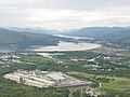
Inverlochy, aluminium plant, Corpach and Loch Eil.

See also
 In Spanish: Fort William para niños
