
Isle of Skye facts for kids
| Gaelic name | An t-Eilean Sgitheanach |
|---|---|
| Norse name | Skíð |
| Meaning of name | Etymology unclear |
 |
|
_-_geograph.org.uk_-_1353645.jpg) Bank Street, Portree |
|
| OS grid reference | NG452319 |
| Coordinates | 57°18′25″N 6°13′48″W / 57.307°N 6.230°W |
| Physical geography | |
| Island group | Skye |
| Area | 1,656 km2 (639 sq mi) |
| Area rank | 2 |
| Highest elevation | Sgùrr Alasdair, 993 m (3,258 ft) |
| Administration | |
| Sovereign state | United Kingdom |
| Country | Scotland |
| Council area | Highland |
| Demographics | |
| Population | 10,008 |
| Population density | 6.04/km2 (15.6/sq mi) |
| Largest settlement | Portree |
The Isle of Skye, often called Skye, is the biggest and most northern of the main islands in the Inner Hebrides of Scotland. Its Gaelic name is Scottish Gaelic: An t-Eilean Sgitheanach, meaning "the winged isle," or Eilean a' Cheò, "the misty isle." The island's shape looks like wings spreading out from a central mountain area. This area is dominated by the Cuillin mountains, which have dramatic rocky slopes.
People have lived on Skye since the Mesolithic period (Middle Stone Age). Over time, different groups have called it home. These include Celtic tribes like the Picts and Gaels, and later, Viking settlers from Scandinavia. The powerful Norse-Gaelic clans of MacLeod and MacDonald were also very important here. Skye was under the control of Norway until 1266. That's when the Treaty of Perth gave control of the island to Scotland.
In the 18th century, the Jacobite risings (attempts to bring back the Stuart kings) led to big changes. The old clan system was broken up. Later, the Highland Clearances happened. This was a time when many communities were forced to leave their homes. Their land was then used for sheep farms. Many people had to move far away to other countries. The number of people living on Skye dropped from over 20,000 in the early 1800s to less than 9,000 by the late 1900s. However, Skye's population grew by 4% between 1991 and 2001. About a third of the people living there in 2001 spoke Scottish Gaelic. Even though fewer people speak it now, this part of the island's culture is still very important.
Today, the main jobs on Skye are in tourism, farming, fishing, and forestry. Skye is part of the Highland Council area. Its biggest town is Portree, which is also its capital. Portree is famous for its beautiful harbour. You can travel to nearby islands by ferry. Since 1995, a road bridge connects Skye to the Scottish mainland. The weather on Skye is usually mild, wet, and windy. The island is home to many animals, including golden eagles, red deer, and Atlantic salmon. The land is mostly covered in heather moors. Important invertebrates live in the sea around the island. Skye has been featured in many books and movies, and it's celebrated in poems and songs.
Contents
What's in a Name? The Etymology of Skye
The first written records of Skye come from Roman times. They called the island Scitis and Scetis. One idea for the name comes from skitis, an old Celtic word meaning "winged." This might describe how the island's peninsulas spread out like wings from its mountainous center.
Over time, Gaelic, Norse, and English speakers have all lived on Skye. They have influenced the island's name. It's not clear exactly how the name "Skye" came to be. People have suggested meanings like "winged isle" or "the notched isle." But no one has found a definite answer yet. The name might even come from a language older than Gaelic.
Exploring Skye's Geography


Skye covers about 1,656 km2 (639 sq mi). This makes it the second-largest island in Scotland, after Lewis and Harris. Skye's coastline has many peninsulas and bays. These stretch out from the center of the island, which is dominated by the Cuillin hills. These hills are called An Cuiltheann in Gaelic.
The island's shape is very unique. One writer said it "sticks out of the west coast of northern Scotland like a lobster's claw." Another noted that Skye is 60 miles (100 km) long, but its width is hard to measure because of its many inlets. This unusual shape is due to 15 large sea lochs. These lochs cut so deeply into the island that no part of Skye is more than 8 kilometres (5.0 mi) from the sea.
Skye's Famous Mountains
The Black Cuillin mountains are made mostly of basalt and gabbro rock. They include 12 Munros, which are Scottish mountains over 3,000 feet (914 meters) high. These mountains offer some of Scotland's most challenging climbing and hiking. Climbing Sgùrr a' Ghreadaidh is one of the longest rock climbs in Britain. The Inaccessible Pinnacle is the only peak in Scotland that needs special climbing skills to reach the top. Nearby, Sgùrr Alasdair is the tallest mountain on any Scottish island. Hiking the entire Cuillin ridge can take 15–20 hours.
To the east are the Red Hills, also known as the Red Cuillin (Gaelic: Am Binnean Dearg). These hills are mostly made of granite. They have weathered into more rounded shapes with long slopes of loose rock. The highest point here is Glamaig.
Unique Rock Formations
The northern peninsula of Trotternish has rich soils because of its basalt rock. This area also has many unusual rock features. The Kilt Rock is a 105-metre (344 ft) cliff. Its columns of rock look like the pleats of a kilt. The Quiraing is a stunning area with many tall, pointed rock formations. Further south is the famous rock pillar called the Old Man of Storr. The views of the Quiraing and the Old Man of Storr are some of Scotland's most famous sights. They often appear on calendars and in tourism guides.
Skye's Peninsulas
West of Trotternish is the Waternish peninsula, which ends at Ardmore Point with its double rock arch. The Duirinish peninsula is separated from Waternish by Loch Dunvegan. This loch contains the island of Isay. Duirinish is surrounded by sea cliffs, reaching 296 metres (971 feet) at Waterstein Head. At Biod an Athair, the cliffs drop 1,029 feet (314 metres) to the ocean.
Lochs Bracadale and Harport, and the island of Wiay, are between Duirinish and Minginish. Minginish includes the narrow valleys of Talisker and Glen Brittle. Its beaches have black sand made from basalt rock. Strathaird is a smaller peninsula near the Cuillin hills. It has only a few crofting communities. The island of Soay is just offshore.
The southern part of Skye, called Sleat, has a bedrock of Torridonian sandstone. This creates poor, boggy ground. However, its lower areas and sheltered eastern shores allow for lush hedgerows and crops to grow. The islands of Raasay, Rona, Scalpay, and Pabay are located to the north and east of Skye, between it and the mainland.
Towns and Villages of Skye


Portree is in the north, at the base of Trotternish. It is the largest town on Skye, with about 2,264 people in 2011. Portree is the main service center for the island. It has hotels, hostels, B&Bs, banks, churches, cafes, restaurants, a cinema, a swimming pool, a library, and supermarkets. Many visitors choose Portree as their base for exploring Skye.
Broadford is on the east side of the island. It has Skye's only airstrip. Dunvegan in the north-west is famous for its castle and the nearby Three Chimneys restaurant. The Stein Inn on the Waternish coast is the oldest pub on Skye, dating back to the 18th century.
Kyleakin is connected to Kyle of Lochalsh on the mainland by the Skye Bridge. This bridge crosses the narrow Loch Alsh. Uig is a port on the west of the Trotternish peninsula. Ferries from Uig go to the Outer Hebrides. Edinbane is located between Dunvegan and Portree. Most of the other people on Skye live in small farming communities called crofting townships, scattered along the coastline.
Skye's Climate and Weather
Skye has a mild oceanic climate. This is due to the influence of the Atlantic Ocean and the Gulf Stream. Temperatures are generally cool. In January, the average is about 6.5 °C (43.7 °F). In July, it's around 15.4 °C (59.7 °F) in Duntulm. Snow rarely stays on the ground at sea level, and there are fewer frosts than on the mainland.
Winds can be strong on Skye. South-westerly winds are the most common. Speeds of 128 km/h (80 mph) have been recorded. High winds are especially likely on the exposed coasts of Trotternish and Waternish. Like most islands on Scotland's west coast, Skye gets a lot of rain, usually 1,500–2,000 mm (59–79 in) per year. The Cuillin mountains get even more rain. The north of the island tends to be drier than the south. Broadford, for example, averages over 2,870 mm (113 in) of rain each year. Trotternish usually has 200 hours of sunshine in May, which is the sunniest month.
| Climate data for Duntulm, Skye | |||||||||||||
|---|---|---|---|---|---|---|---|---|---|---|---|---|---|
| Month | Jan | Feb | Mar | Apr | May | Jun | Jul | Aug | Sep | Oct | Nov | Dec | Year |
| Record high °C (°F) | 13.5 (56.3) |
12.5 (54.5) |
16.7 (62.1) |
22.3 (72.1) |
26.7 (80.1) |
24.5 (76.1) |
25.9 (78.6) |
25.6 (78.1) |
22.1 (71.8) |
19.3 (66.7) |
17.3 (63.1) |
15.0 (59.0) |
26.7 (80.1) |
| Mean daily maximum °C (°F) | 6.5 (43.7) |
6.6 (43.9) |
8.1 (46.6) |
9.6 (49.3) |
12.4 (54.3) |
14.3 (57.7) |
15.4 (59.7) |
15.7 (60.3) |
14.2 (57.6) |
11.5 (52.7) |
9.1 (48.4) |
7.6 (45.7) |
10.9 (51.6) |
| Mean daily minimum °C (°F) | 2.4 (36.3) |
2.2 (36.0) |
3.3 (37.9) |
4.3 (39.7) |
6.5 (43.7) |
8.7 (47.7) |
10.4 (50.7) |
10.7 (51.3) |
9.4 (48.9) |
7.2 (45.0) |
5.1 (41.2) |
3.6 (38.5) |
6.2 (43.2) |
| Record low °C (°F) | −4.0 (24.8) |
−3.5 (25.7) |
−4.1 (24.6) |
−3.4 (25.9) |
0.0 (32.0) |
4.2 (39.6) |
5.2 (41.4) |
4.7 (40.5) |
2.6 (36.7) |
0.3 (32.5) |
−4.5 (23.9) |
−6.5 (20.3) |
−6.5 (20.3) |
| Average precipitation mm (inches) | 148 (5.84) |
100 (3.93) |
82 (3.24) |
86 (3.40) |
73 (2.87) |
85 (3.35) |
97 (3.83) |
112 (4.41) |
128 (5.05) |
152 (6.00) |
143 (5.63) |
142 (5.58) |
1,350 (53.13) |
| Source 1: Cooper (1983) | |||||||||||||
| Source 2: Met office for May and December record high, bing weather | |||||||||||||
| Climate data for Prabost, Skye (67 metres asl) 1981–2010 | |||||||||||||
|---|---|---|---|---|---|---|---|---|---|---|---|---|---|
| Month | Jan | Feb | Mar | Apr | May | Jun | Jul | Aug | Sep | Oct | Nov | Dec | Year |
| Mean daily maximum °C (°F) | 6.4 (43.5) |
6.8 (44.2) |
8.2 (46.8) |
10.8 (51.4) |
13.9 (57.0) |
15.5 (59.9) |
16.8 (62.2) |
16.8 (62.2) |
14.7 (58.5) |
11.7 (53.1) |
8.7 (47.7) |
6.7 (44.1) |
11.4 (52.5) |
| Mean daily minimum °C (°F) | 1.6 (34.9) |
1.5 (34.7) |
2.3 (36.1) |
3.9 (39.0) |
6.1 (43.0) |
8.5 (47.3) |
10.5 (50.9) |
10.4 (50.7) |
8.5 (47.3) |
6.2 (43.2) |
3.8 (38.8) |
1.7 (35.1) |
5.4 (41.7) |
| Average rainfall mm (inches) | 211.2 (8.31) |
158.2 (6.23) |
160.4 (6.31) |
93.9 (3.70) |
79.2 (3.12) |
81.4 (3.20) |
106.7 (4.20) |
129.3 (5.09) |
169.6 (6.68) |
209.2 (8.24) |
209.3 (8.24) |
197.8 (7.79) |
1,806.2 (71.11) |
| Average rainy days | 21.8 | 18.5 | 21.1 | 14.7 | 13.8 | 14.4 | 16.5 | 17.6 | 19.0 | 23.3 | 21.9 | 20.7 | 223.2 |
| Mean monthly sunshine hours | 34.2 | 61.1 | 93.0 | 138.6 | 195.9 | 155.9 | 128.6 | 115.2 | 97.5 | 68.7 | 37.7 | 34.0 | 1,160.2 |
| Source: metoffice.gov.uk | |||||||||||||
| Climate data for Lusa, Skye (18 metres asl) 1981–2010 | |||||||||||||
|---|---|---|---|---|---|---|---|---|---|---|---|---|---|
| Month | Jan | Feb | Mar | Apr | May | Jun | Jul | Aug | Sep | Oct | Nov | Dec | Year |
| Mean daily maximum °C (°F) | 7.2 (45.0) |
7.5 (45.5) |
8.9 (48.0) |
11.1 (52.0) |
13.9 (57.0) |
15.6 (60.1) |
17.0 (62.6) |
17.1 (62.8) |
15.1 (59.2) |
12.4 (54.3) |
9.5 (49.1) |
7.2 (45.0) |
11.9 (53.4) |
| Mean daily minimum °C (°F) | 2.1 (35.8) |
2.0 (35.6) |
2.9 (37.2) |
4.0 (39.2) |
6.3 (43.3) |
8.9 (48.0) |
10.8 (51.4) |
10.8 (51.4) |
9.1 (48.4) |
6.7 (44.1) |
4.3 (39.7) |
2.2 (36.0) |
5.9 (42.6) |
| Average rainfall mm (inches) | 252.2 (9.93) |
173.9 (6.85) |
190.8 (7.51) |
113.8 (4.48) |
92.0 (3.62) |
89.6 (3.53) |
105.7 (4.16) |
137.4 (5.41) |
190.2 (7.49) |
232.5 (9.15) |
227.0 (8.94) |
231.6 (9.12) |
2,036.6 (80.18) |
| Average rainy days | 20.7 | 17.5 | 20.6 | 15.3 | 12.8 | 13.3 | 16.3 | 17.9 | 17.8 | 20.5 | 20.5 | 20.3 | 213.4 |
| Source: metoffice.gov.uk | |||||||||||||
Skye's Rich History
Ancient Times: Prehistory on Skye
One of Scotland's oldest archaeological sites is at An Corran in Staffin. It dates back to the Mesolithic period (about 7,000 BC). Tools found here suggest that people traveled long distances. They used boats and walked over land to get materials from other islands like Rùm.

Rubha an Dùnain is an uninhabited peninsula south of the Cuillin. It has many ancient sites. These include a chambered cairn (a burial mound) from 2,000-3,000 BC. There's also an Iron Age fort and remains of a Bronze Age settlement. A man-made "Viking canal" links Loch na h-Airde to the sea. This canal might be from the later Norse settlement period. Dun Ringill is a ruined Iron Age hill fort. It was later made stronger in the Middle Ages. It might have been the home of Clan MacKinnon.
Early History: Picts, Gaels, and Vikings
The people living in northern and western Hebrides during the late Iron Age were likely Pictish. We don't have many written records from this time. Three Pictish symbol stones have been found on Skye. The kingdom of Dál Riata to the south is better known. Adomnán's book about Columba (written before 697) says the saint visited Skye. He even baptized a pagan leader there with an interpreter.
Legend says that the hero Cú Chulainn trained on Skye. He learned from the warrior woman Scáthach.
The Norse people (Vikings) ruled the Hebrides from the 9th century. They stayed until the Treaty of Perth in 1266. Not much remains of their time on Skye, except for place names. Almost all older, non-Norse place names were replaced by Scandinavian ones. Clan MacLeod claims both Viking and Celtic heritage. The winter fire festival at Dunvegan celebrates Norse tradition. A replica Viking longboat is set on fire during this festival.
Clans and Scottish Rule
After the Norse period, the most powerful clans on Skye were Clan MacLeod and Clan Macdonald of Sleat. Clan MacLeod was originally based in Trotternish. Skye was part of Ross from 1389 to 1401. When Donald Macdonald, Lord of the Isles, regained Ross in 1411, Skye became part of his lands.
Later, Clan Mackinnon also became an independent clan. Their lands on Skye were mainly in Strathaird. Clan MacNeacail has a long history with Trotternish. In the 16th century, many of the MacInnes clan moved to Sleat. The MacDonalds of South Uist and the MacLeods were fierce rivals. A fight called the Battle of the Spoiling Dyke happened in 1578. It was a revenge attack for an earlier massacre on Eigg.

After the Jacobite rebellion of 1745 failed, Flora MacDonald became famous. She helped Prince Charles Edward Stuart escape from the Hanoverian troops. She was born in South Uist, but her story is strongly linked to her escape through Skye. She is buried at Kilmuir in Trotternish.
In 1773, Samuel Johnson and James Boswell visited Skye. They met Flora MacDonald in Kilmuir. Boswell wrote that it was "a striking sight" to see Johnson, a famous English Tory, greet Flora MacDonald. Johnson wrote on her gravestone that she was "A name that will be mentioned in history, and if courage and fidelity be virtues, mentioned with honour." After this rebellion, the clan system ended. Skye became a place of large estates owned by landowners.
Skye has many old monuments from this time. Dunvegan Castle has been the home of Clan MacLeod since the 13th century. It holds the famous Fairy Flag. It is believed to be the oldest continuously inhabited house in Scotland. The 18th-century Armadale Castle was once home to Clan Donald of Sleat. It is now a visitor center. Nearby are the ruins of two other MacDonald strongholds: Knock Castle and Dunscaith Castle. Dunscaith was the legendary home of the warrior woman Scáthach. Caisteal Maol, a fortress built in the late 15th century near Kyleakin, is another ruin. It was once a seat of Clan MacKinnon.
Changes in Population: Economic Turmoil and Emigration

In the late 1700s, collecting kelp (seaweed) was important. But after 1822, cheap imports caused this industry to collapse. In the 1800s, Skye's people also suffered from famine and the Highland Clearances. Between 1840 and 1880 alone, 30,000 people were forced to leave their homes. Many had to move to the New World.
The "Battle of the Braes" was a protest against not having access to land. It involved many crofters and about 50 police officers. This event helped create the Napier Commission. This group looked into the situation in the Highlands in 1884. Protests continued until the Crofters' Act was passed in 1886. At one point, 400 marines were sent to Skye to keep order. You can still see the ruins of villages that were cleared. These include Lorgill, Boreraig, Suisnish, and Tusdale.
Population Trends on Skye
| Year | 1755 | 1794 | 1821 | 1841 | 1881 | 1891 | 1931 | 1951 | 1961 | 1971 | 1981 | 1991 | 2001 | 2011 | 2017 |
|---|---|---|---|---|---|---|---|---|---|---|---|---|---|---|---|
| Population | 11,252 | 14,470 | 20,827 | 23,082 | 16,889 | 15,705 | 9,908 | 8,537 | 7,479 | 7,183 | 7,276 | 8,847 | 9,232 | 10,008 | 13,143 |
Like many Scottish islands, Skye's population was highest in the 1800s. It then dropped because of the Clearances. By 1971, the population was less than a third of its peak in 1841. However, the number of people living on Skye grew by over 28% in the 30 years leading up to 2001. By 2011, the population had risen another 8.4% to 10,008 people.
Language and Culture
Historically, most people on Skye spoke Scottish Gaelic. But this changed between 1921 and 2001. In 1901 and 1921, over 75% of people in all Skye parishes spoke Gaelic. By 2001, only Kilmuir parish had almost half Gaelic speakers. Overall, 31% of people on Skye spoke Gaelic. The areas with the most Gaelic speakers were in the north and southwest, like Staffin (61%).
Students from all over the world come to Sabhal Mòr Ostaig. This is a Scottish Gaelic college near Kilmore in Sleat. Many people on Skye belong to the Free Church of Scotland. This church is known for its strict observance of the Sabbath (Sunday).
Skye has a strong folk music tradition. But in recent years, dance and rock music have become more popular. The Gaelic folk rock band Runrig started on Skye. Their former singer, Donnie Munro, still works on the island. The band has songs like "Skye" and "Nightfall on Marsco" inspired by the island. Electronic musician Mylo was born on Skye.

The poet Sorley MacLean lived much of his life on Skye. The island is famous from the traditional song "The Skye Boat Song." Skye has also been a setting for many books and films. Some opening scenes of the 2012 film Prometheus were filmed at the Old Man of Storr. The Scottish Gaelic TV series Bannan was also filmed on the island.
The West Highland Free Press is a weekly newspaper published in Broadford. Its motto is An Tìr, an Cànan 's na Daoine, meaning "The Land, the Language, and the People." This shows its focus on local issues. Shinty is a popular sport on the island. The Portree-based team, Skye Camanachd, won the Camanachd Cup in 1990. Radio Skye is a local community radio station.

Skye now has an official flag called "Bratach an Eilein" (The Skye Flag). It was approved in August 2020 after a public vote. The flag's design shows the island's Gaelic and Viking heritage. It also honors Flora MacDonald. It has a birlinn (a type of boat) and five oars. The oars represent Skye's five main areas: Trotternish, Waternish, Duirinish, Minginish, and Sleat. Yellow represents the MacLeods, and blue represents the MacDonalds or MacKinnons.
Government and Politics on Skye

From 1975 to 1996, Skye was part of a local government district with Lochalsh on the mainland. In 1996, it became part of the Highland Council. This council is based in Inverness. Skye now forms a four-member ward called Eilean a' Cheò. It is currently represented by councillors from different political groups.
Skye is in the Highlands and Islands electoral region for the Scottish Parliament. It is part of the Skye, Lochaber and Badenoch constituency. This constituency elects one member (MSP). Kate Forbes is the current MSP for the Scottish National Party (SNP).
Skye is also part of the Ross, Skye and Lochaber constituency for the UK Parliament in Westminster. This constituency elects one Member of Parliament (MP). The current MP is Ian Blackford of the Scottish National Party. Before him, Charles Kennedy represented the area for many years.
Skye's Economy and Tourism

The biggest employer on Skye is the public sector. This includes jobs in government, education, and health. Tourism is also very important. Key attractions include Dunvegan Castle, the Clan Donald Visitor Centre, and The Aros Experience in Portree.
There are about a dozen large landowners on Skye. The Scottish Government owns most of the northern part of the island. Glendale is a community-owned estate. The Sleat Community Trust works on various projects to improve the area.
Small businesses are common in the private sector. The Talisker Distillery makes single malt whisky. It is located near Loch Harport. The Torabhaig distillery also makes whisky and opened in 2017. Other whiskies are produced by Pràban na Linne at Eilean Iarmain. These whiskies often have Gaelic names. There are also software companies on Skye, like Sitekit in Portree.
Crofting (small-scale farming) is still important. There are about 2,000 crofts on Skye. But only about 100 are big enough for a crofter to live solely from the land. Recently, land prices have increased, making it hard for young people to start their own crofts.
Commercial fishing is still important, even though cod and herring stocks have decreased. Fish farming, especially of salmon and crustaceans like scampi, is also done. The west coast of Scotland has a lot of potential for renewable energy. The Isle of Skye Renewables Co-op has invested in the Ben Aketil wind farm. There is also a lively arts and crafts scene.
Unemployment on Skye tends to be higher than in the rest of the Highlands. It also changes with the seasons, partly because of tourism. The population is growing. Like other scenic rural areas in Scotland, Skye expects to see more people aged 45 to 64 years.
The COVID-19 pandemic greatly affected tourism in the Highlands and Islands. In summer 2020, unemployment in the region rose to 5.7%. This was much higher than the 2.4% in 2019. The Scottish government introduced schemes to help businesses affected by the pandemic.
Tourism on Skye
.jpg)
Before the pandemic, visitors to Skye added £211 million to the island's economy in 2019. In 2018, Skye and Raasay attracted 650,000 visitors and supported 2,850 jobs. However, the pandemic caused a big drop in tourism.
In summer 2017, some islanders felt there were too many tourists. Popular spots like Glen Brittle, Neist Point lighthouse, the Quiraing, and the Old Man of Storr became very crowded. People complained about parking problems and overcrowding. While tourism brings many benefits, like jobs and money, managing the large number of visitors is a challenge.
Getting Around: Transport on Skye
Skye is connected to the mainland by the Skye Bridge. Ferries also sail from Armadale to Mallaig. Another ferry goes from Kylerhea to Glenelg. This ferry, the MV Glenachulish, is the last turntable ferry in the world. Turntable ferries were common because they don't need much port infrastructure.

Ferries also run from Uig to Tarbert on Harris and Lochmaddy on North Uist. From Sconser, you can take a ferry to Raasay.
The Skye Bridge opened in 1995. It used to have high tolls, which caused a lot of opposition. A group called SKAT (Skye and Kyle Against Tolls) led protests. On December 21, 2004, the Scottish Executive bought the bridge. The tolls were removed immediately, making travel much easier.
Bus services connect Skye to Inverness and Glasgow. There are also local bus services on the island, mainly from Portree or Broadford. Train services run from Kyle of Lochalsh (on the mainland side of the bridge) to Inverness. You can also take a train from Glasgow to Mallaig, then catch a ferry to Armadale.
The island's airfield at Ashaig, near Broadford, is used by private planes. It's also used by NHS Highland and the Scottish Ambulance Service to take patients to mainland hospitals. The A87 is the main road that crosses the island. It goes from the Skye Bridge to Uig, connecting most of the major towns. Many of Skye's roads have been made wider in the last 40 years. However, there are still long sections of single-track road.
Wildlife on Skye

Skye has a good variety of wildlife. Bird life includes the corncrake, red-throated diver, kittiwake, tystie, Atlantic puffin, goldeneye, and golden eagle. The white-tailed sea eagle used to breed on Skye but disappeared. However, it has recently been brought back to the UK. The chough bird last bred on the island in 1900.
Mountain hares and rabbits are now common. They are hunted by wild cats and pine martens. The island's fresh water streams have brown trout, Atlantic salmon, and water shrew. In the sea, you can find edible crabs and edible oysters. There are important beds of horse mussels and brittlestars in the sea lochs. In 2012, a bed of 100 million flame shells was found in Loch Alsh. You can also see Grey Seals off the southern coast.
Plants and Habitats on Skye
Heather moorland is very common on Skye. It contains plants like ling, bell heather, cross-leaved heath, bog myrtle, and fescue grasses. The Black Cuillins mountains weather slowly, so their soil doesn't support a lot of plant life. But each of Skye's main peninsulas has its own unique plants.
The basalt rock under Trotternish allows many Arctic and alpine plants to grow. These include alpine pearlwort and mossy cyphal. The low-lying fields of Waternish have corn marigold and corn spurry. The sea cliffs of Duirinish are home to mountain avens and fir clubmoss. Minginish has plants like fairy flax, cats-ear, and black bog rush. There is a beautiful ash woodland at Tokavaig in Sleat. It includes silver birch, hazel, bird cherry, and hawthorn.
The local Biodiversity Action Plan suggests ways to manage the land. This includes controlling the spread of ragwort and bracken. It also points out four non-native plants and animals that threaten local wildlife. These are Japanese knotweed, rhododendron, New Zealand flatworm, and mink. The plan also notes problems from too much grazing by red deer and sheep. This can harm moorland and native woodlands.
In 2020, Clan MacLeod chief Hugh MacLeod announced a plan. He wants to reintroduce 370,000 native trees to the clan estates on Skye. He also plans to bring back beaver and red squirrel populations. The goal is to restore the landscape, which has been damaged by years of overgrazing.

Images for kids
-
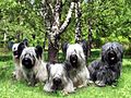
Skye Terriers
-
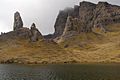
Rock pinnacles of The Storr, which feature in some of the opening scenes in the film Prometheus
-
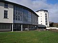
The new college buildings, Sabhal Mòr Ostaig


See also
 In Spanish: Isla de Skye para niños
