
Outer Hebrides facts for kids
Quick facts for kids
Outer Hebrides
(The Western Isles) |
|
|---|---|
 |
|
| Admin HQ | Stornoway |
| Government | |
| • Body | Comhairle nan Eilean Siar |
| Area | |
| • Total | Formatting error: invalid input when rounding sq mi (3,071 km² km2) |
| Area rank | Ranked 7th |
| • Rank | Ranked |
| ONS code | 00RJ |
| ISO 3166 code | GB-ELS |
The Outer Hebrides, also known as the Western Isles, are a chain of islands located off the west coast of Scotland. This area is also a special region that elects its own representatives to the Scottish Parliament. The largest island in the north is Lewis and Harris. South of Lewis and Harris, you'll find other islands like South Uist, Benbecula, and North Uist. Many smaller islands are also part of the Outer Hebrides.
These islands are part of the larger Hebrides group. They are separated from mainland Scotland and the Inner Hebrides by the often-stormy waters of the Minch, the Little Minch, and the Sea of the Hebrides.
Long ago, Scottish Gaelic was the main language spoken on these islands. While many people now speak English, Gaelic is still an important language in some areas.
Getting around the islands and to mainland Britain relies a lot on sea transport. Many ferry services connect the islands to each other and to the mainland.
History of the Western Isles
The Western Isles were once part of a kingdom called Suðreyjar, ruled by the Norse people. They controlled the islands for over 400 years. In 1266, control of the islands was officially given to Scotland through the Treaty of Perth. After this, powerful clan chiefs took charge of the islands.
Land and Climate
Most of the islands are made of very old metamorphic rocks. The weather here is generally mild and influenced by the ocean. This is partly because the Gulf Stream, a warm ocean current, flows nearby. There are 15 islands where people live, with a total population of about 26,500. There are also more than 50 other islands that are not inhabited.
Plants and Animals
Much of the Outer Hebrides, including both the land and the surrounding sea, is a protected area for nature. There are 53 special places called Sites of Special Scientific Interest (SSSI). The biggest of these are Loch an Duin in North Uist, which is about 15,100 hectares (37,313 acres), and North Harris, which covers about 12,700 hectares (31,382 acres).

Loch Druidibeg on South Uist is a National Nature Reserve. It is managed by Scottish Natural Heritage. This reserve covers 1,677 hectares (4,144 acres) and includes all the different types of natural habitats found in the area.
Images for kids
-
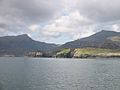
Nicolson's Leap on the east coast of South Uist. In the background are Beinn Mhòr at left, and Hecla on the right.
-
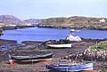
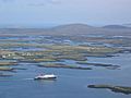
Bàgh Mòr, Grimsay
-
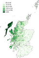
Geographic distribution of Gaelic speakers in Scotland (2011)
-
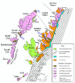
Geological map of the Hebridean Terrane
-
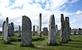
The Callanish Stones
-
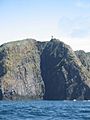
The "Old Boy" — the gneiss cliffs of Sloc na Bèiste, Barra Head, the southernmost point of the Outer Hebrides
-
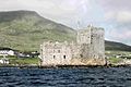
Kisimul Castle, the ancient seat of Clan MacNeil, Castlebay, Barra
-
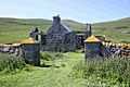
Abandoned school house, Mingulay
-
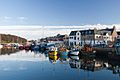
Stornoway Harbour
-
Caledonian MacBrayne ferry MV Hebrides leaving Lochmaddy, North Uist, en route for Skye
-
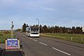
Bus Na Comhairle Optare Solo YJ14 BDY seen in Sandwick - May 2020
-
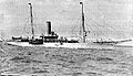
The Admiralty yacht HMS Iolaire


See also
 In Spanish: Islas Hébridas Exteriores para niños
