Vatersay facts for kids
| Gaelic name | Bhatarsaigh |
|---|---|
| Meaning of name | Water island |
 Bàgh Siar (West Bay) |
|
| OS grid reference | NL635955 |
| Coordinates | 56°56′N 7°32′W / 56.93°N 7.53°W |
| Physical geography | |
| Island group | Uist and Barra |
| Area | 960 ha (3.7 sq mi) |
| Area rank | 51 |
| Highest elevation | Heiseabhal Mòr, 190 m (623 ft) |
| Administration | |
| Sovereign state | United Kingdom |
| Country | Scotland |
| Council area | Comhairle nan Eilean Siar |
| Demographics | |
| Population | 90 |
| Population density | 9.4/km2 (24/sq mi) |
| Largest settlement | Baile Bhatarsaigh |
Vatersay (pronounced VAH-ter-say, or Bhatarsaigh in Scottish Gaelic) is a beautiful island in Scotland. It's the most southern and western island in the Outer Hebrides where people live. The small village of Caolas on Vatersay is even the most western place in all of Scotland where people live all the time! The main village, also called Vatersay, is located in the south of the island.
Contents
Discover Vatersay Island
Exploring Vatersay's Unique Shape
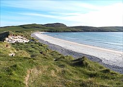
Vatersay has a unique shape! It's actually like two rocky islands joined together by a sandy bridge called a tombolo. This sandy bridge is covered in sand dunes. On either side of this sandy bridge, you'll find large, beautiful white-sand beaches. These are Bàgh Siar (West Bay) and Bàgh Bhatarsaigh (Vatersay Bay) to the east. The island has many beaches, and most of them have sand dunes behind them.
The island is about 3 miles (5 kilometres) long from north to south. The northern part of the island is about 3.5 miles (5.5 kilometres) wide from west to east.
How Vatersay Connects to Other Islands
Vatersay is connected to the larger island of Barra to its north. They are linked by the Vatersay Causeway, a road bridge about 250 metres (820 feet) long. This causeway was finished in 1991. It's a huge help for the islanders! Before the causeway, people and goods had to rely on a small ferry boat. Now, it's much quicker and easier to get to school or for emergency services to reach the island. The causeway is about 2 miles (3 kilometres) by road from Castlebay, a town on Barra.
When the tide is low, Vatersay is also connected to a small island called Uineasan to the east. To the south of Vatersay, you'll find the islands of Pabbay, Mingulay, and Sandray. No one lives on these southern islands.
Wildlife on Vatersay
Vatersay is home to some amazing wildlife! You might spot Eurasian otters playing in the water or seals resting on the shores. Grey herons are also often seen around the island.
Unique Plants and Flowers
One very special plant found here is Bonnie Prince Charlie's flower (Calystegia soldanella). Legend says this flower grew from French seeds dropped by Bonnie Prince Charlie himself! In all of Scotland, this flower only grows on Vatersay and the nearby island of Eriskay. You can also find cute Atlantic puffins on Vatersay, especially during nesting season.
Vatersay's Ancient History
Vatersay has a long and interesting history, with many ancient sites.
- Iron Age Fort: You can find the remains of an Iron Age fort, called a broch, at Dun a' Chaolais. It looks out over the Sound of Vatersay.
- Ancient Burial Sites: Near the broch, there's a passage grave that is about 5,000 years old (from the 3rd millennium BC). There's also a Bronze Age cemetery at Trèseabhaig, south of the Heiseabhal Mòr hills. A stone pile, or cairn, built around 1000 BC, is located west of Vatersay village.
- Offshore Fort: The small island of Bioruaslum, just offshore, has a walled fort. This fort might be from the Neolithic period, which was even earlier than the Bronze Age!
The Vatersay Land Story
At the end of the 1800s, the island's owner wanted to use all the land for their own farming. Because of this, they asked all the local farmers, called crofters, to leave their homes.
The Vatersay Raiders
Between 1902 and 1906, some of these farmers, known as the "Vatersay Raiders," returned to the island. They took back parts of the land. They believed an old law allowed a person to claim land by building a wooden home and lighting a fire in it within one day. However, the landowner, Lady Gordon Cathcart, took them to court, and they were sent to prison.
There was a lot of public protest about this. Because of the protests, in 1909, a group called the Congested Districts Board (Scotland) bought Vatersay island for £6250. The island was then divided into 58 smaller farms, or crofts, for the local people.
Shipwrecks and Memorials
Vatersay's coast has seen some dramatic events, including shipwrecks.
The Annie Jane Disaster
In September 1853, a three-masted ship named the Annie Jane was sailing from Liverpool to Montreal, Quebec, Canada. It was carrying many people who were moving to a new country. During a big storm, the ship hit rocks off West Beach. In just ten minutes, the ship began to sink and break apart, throwing about 450 people into the wild sea. Even with the terrible conditions, the islanders bravely tried to rescue the passengers and crew.
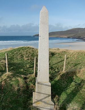
Only a few people survived this disaster. A small pile of stones (a cairn) and a monument mark the spot where the bodies found from the sea were buried. The monument has an inscription that says:
On 28th September 1853 the ship Annie Jane with emigrants from Liverpool to Quebec was totally wrecked in this bay and threefourths of the crew and passengers numbering about 350 men women and children were drowned and their bodies interred here.
Other Wrecks
Two sailors from China, who were on a ship called the SS Idomeneus that sank on September 28, 1917, are also buried near this monument. There is a special headstone for them in Cuier Churchyard.
You can also find the remains of a Catalina flying boat that crashed on the slopes of Heiseabhal Beag in 1944. Its parts lie in a stream bed near the shore.
See also
 | William Lucy |
 | Charles Hayes |
 | Cleveland Robinson |


