Ordnance Survey National Grid facts for kids
The Ordnance Survey National Grid is a special system used to map Great Britain. It helps people find exact locations. This system is different from using latitude and longitude. The Ordnance Survey (OS) created it. They use it a lot in their maps and data.
Contents
Finding Your Way with the National Grid
Imagine a giant invisible grid covering all of Great Britain! That's basically what the Ordnance Survey National Grid is. It's a clever way to give every single spot a unique code. This code makes it easy to pinpoint locations on a map.
Big Grid Squares: 500 Kilometres
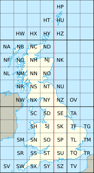
The first step in this system is to divide the whole map into very large squares. Each of these squares is 500 kilometres (about 310 miles) on each side. These huge squares are labelled with a single letter. You can see them outlined in dark grey on the map.
Only a few of these big squares cover most of the land in Great Britain. These are the S, T, N, and H squares. There's also a tiny bit of the O square in North Yorkshire. Most of this small area is often underwater when the tide is high.
Smaller Squares: 100 Kilometres
Next, each of those 500 kilometre squares is divided again. This time, they are split into 25 smaller squares. Each of these new squares is 100 kilometres (about 62 miles) on each side.
These 100 kilometre squares also get a letter code. They go from A to Z, but the letter I is not used. The letters start with A in the top-left (northwest) corner. They then go across and down, ending with Z in the bottom-right (southeast) corner. These squares are shown with light grey lines on the map. The ones that have land on them show their letter.
Pinpointing Locations with Numbers
The system can also help you find even smaller areas. You do this by adding numbers to the two letters. These numbers tell you how far east and north a spot is from the bottom-left (southwest) corner of the 100 kilometre square.
For example, a code like NH0325 (or NH 03 25) means a one-kilometre square. Its southwest corner is 3 kilometres east and 25 kilometres north from the southwest corner of the NH square.
You can even find areas smaller than one kilometre! For instance, the exact spot for the top of Ben Nevis (the UK's highest mountain) is NN 166 712. This code points to a 100-metre square.
- Standing, Peter (2006) OV0000 a unique grid square at Beast Cliff, Geograph Project, UK, web article [accessed 11 June 2007]
 | Stephanie Wilson |
 | Charles Bolden |
 | Ronald McNair |
 | Frederick D. Gregory |


