
Ben Nevis facts for kids
Quick facts for kids Ben Nevis |
|
|---|---|

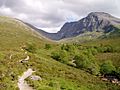
Ben Nevis from Banavie. The summit is beyond and to the left of the apparent highest point.
|
|
| Highest point | |
| Elevation | 1,345 m (4,413 ft) |
| Prominence | 1,345 m (4,413 ft) Ranked 1st in British Isles |
| Isolation | 739 km (459 miles) |
| Parent peak | none – Highest peak on island of Great Britain |
| Listing | Munro, Marilyn, Council top (Highland), County top (Inverness-shire), Country high point |
| Naming | |
| Native name | Error {{native name}}: an IETF language tag as parameter {{{1}}} is required (help) |
| English translation | "Venomous mountain" or "mountain with its head in the clouds" |
| Geography | |

Ben Nevis
Location in Scotland
|
|
| Location | Lochaber, Highland, Scotland, UK |
| Parent range | Grampian Mountains |
| OS grid | NN166712 |
| Topo map | OS Landranger 41, Explorer 392 |
| Climbing | |
| First ascent | 17 August 1771, by James Robertson |
| Easiest route | Pony track and mountain path |
Ben Nevis (Scottish Gaelic: Beinn Nibheis) is the tallest mountain in the British Isles. It is also the highest point in the United Kingdom, Great Britain, and Scotland. The top of the mountain is 1,345 meters (4,413 feet) above sea level.
Ben Nevis is located in the Grampian Mountains in the Scottish Highlands. It is very close to the town of Fort William. The mountain is a very popular place to visit. About 100,000 people climb it every year. Most of them use the easy Pony Track from Glen Nevis.
The northern side of Ben Nevis has cliffs that are 700 meters (2,300 feet) high. These cliffs are great for rock climbing and ice climbing. The very top of the mountain is the remains of an old volcano. There are also ruins of an observatory there. This observatory collected important weather data from 1883 to 1904.
Contents
What Does the Name "Ben Nevis" Mean?
The name "Ben Nevis" comes from the Gaelic name Beinn Nibheis. Beinn means "mountain" in Gaelic. The meaning of Nibheis is not fully clear.
It is often translated as "malicious" or "venomous mountain." Another idea is that it means "the mountain with its head in the clouds." Some people also call it "mountain of Heaven."
Where is Ben Nevis?
Ben Nevis is part of a large mountain group. It is connected to its neighbor, Carn Mòr Dearg, by a ridge called the Carn Mòr Dearg Arête. These mountains are among the tallest in Great Britain.
The western and southern sides of Ben Nevis rise very steeply. They go up 1,200 meters (3,900 feet) in just 2 kilometers (1.2 miles). This makes the mountain look very big and strong from these sides. On the north side, cliffs drop about 600 meters (2,000 feet) into a valley called Coire Leis.
This valley is home to the Charles Inglis Clark Memorial Hut, also known as the CIC Hut. This mountain hut is used by climbers as a base for their routes on the north face.

Ben Nevis also has two smaller "tops" called Carn Dearg ("red hill"). The higher one is 1,221 meters (4,006 feet) tall. It is sometimes mistaken for Ben Nevis itself when seen from Fort William.
How Ben Nevis Was Formed
Ben Nevis is mostly made of igneous rock. This type of rock forms when hot lava cools down. It was formed about 400 million years ago. This rock pushed into older rocks around it. The mountain has also been shaped a lot by glaciation, which means by glaciers moving over it.
Weather on Ben Nevis

The weather on Ben Nevis can be very bad. This is because it is so high and close to the ocean. Bad weather can be dangerous for people climbing the mountain.
From 1883 to 1904, an observatory on the summit recorded the weather. It showed that the summit was often covered in fog. It was foggy almost 80% of the time in winter. The average winter temperature was about -5°C (23°F).
Ben Nevis gets a lot of rain, about 4,350 mm (171 inches) each year. This is much more than nearby towns. Snow can be found on the mountain almost all year round. It stays longest in the deep valleys on the north face.
History of Ben Nevis
The first person to officially climb Ben Nevis was James Robertson. He was a botanist from Edinburgh. He climbed it on August 17, 1771. He was collecting plants in the area.
In 1847, the Ordnance Survey confirmed that Ben Nevis was the highest mountain in Britain. Before that, some thought Ben Macdui was taller.
The summit observatory was built in the summer of 1883. It stayed open for 21 years. The first path to the summit was built at the same time. It was made for ponies to carry supplies up to the observatory. This path made climbing the mountain much more popular.

In 2000, a charity called the John Muir Trust bought the southern part of the mountain, including the summit.
Climbing Ben Nevis

The easiest and most popular way to climb Ben Nevis is the 1883 Pony Track. It is also called the Ben Path or Tourist Route. It starts in Glen Nevis, about 2 kilometers (1.2 miles) from Fort William.
The path climbs steeply at first. Then it goes up the western side of the mountain in a series of zig-zags. This path is well-made and easy to follow.

For more experienced hillwalkers, another popular route starts north-east of Fort William. This route goes up Carn Mòr Dearg. Then it follows the Carn Mòr Dearg Arête. This ridge is a bit challenging and requires a good head for heights. This route offers amazing views of the north face cliffs.
It is also possible to climb Ben Nevis from the Nevis Gorge car park. These routes are shorter and steeper. They are usually used by very experienced hikers.
The Summit of Ben Nevis

The top of Ben Nevis is a large, flat, stony area. The highest point is marked by a big pile of stones called a cairn. There is also an Ordnance Survey trig point on top of the cairn.
The ruined walls of the old observatory are also on the summit. An emergency shelter has been built on top of the observatory tower. This shelter helps people who get caught in bad weather. A war memorial for those who died in World War II is also near the observatory.
In 2006, a piano was found buried under one of the cairns. It is believed that people carried it up for charity over 20 years before.
From the summit, you can see very far on a clear day. You might see mountains over 190 kilometers (120 miles) away. This includes mountains in the Torridon Hills and even in Northern Ireland.
The Summit Observatory

A weather observatory was built on the summit in 1883. It was open for 21 years. Scientists worked there all the time, studying the weather at high altitudes. The observatory closed in 1904 because it did not get enough money from the government.
The weather data collected there is still very important today. It helps us understand mountain weather in Great Britain.
In 1894, a scientist named C. T. R. Wilson worked at the observatory. He saw a Brocken spectre and a glory. These are optical effects caused by the sun shining on clouds. He later tried to create these effects in his lab. This led him to invent the cloud chamber. This device is used to detect radiation.
Staying Safe on Ben Nevis

Because Ben Nevis is so popular and the weather can be bad, many people need to be rescued there. It can be hard to find your way on or off the summit, especially in fog. The top of the mountain is shaped like a kidney. It has cliffs on three sides. This makes it easy to get lost if the main path is covered by snow.
To stay safe, hikers need to use a compass carefully. In the past, some posts were put on the summit to help people find their way. However, some climbers removed them. This caused a debate about whether such aids should be on the mountain.
Supporters say these aids save lives. Critics argue they spoil the natural look of the mountain. They also say it might make climbers less careful about their own safety.
Rock and Ice Climbing

The north face of Ben Nevis is famous for its many scrambles and rock climbs. It is also a very important place for winter climbing in Britain. Many routes have snow until late spring.
The Scottish Mountaineering Club built the Charles Inglis Clark hut below the north face in 1929. It is a very remote hut and is popular with climbers, especially in winter.
Tower Ridge is the longest of the four main ridges on the north face. It is about 600 meters (2,000 feet) long. It is not too difficult, but it is very exposed. Castle Ridge is an easier climb. Observatory Ridge is harder and closer to the summit.

The north face has many different rock climbs. Some classic routes include Rubicon Wall and Centurion. Many famous routes were first climbed between World War I and World War II. Echo Wall is an extremely difficult climb that was finished in 2008.
The north face is also a top spot for winter climbing and ice climbing. Many of the rock routes can also be climbed in winter. The Curtain is a very popular ice climb.
Ben Nevis Race


People have been running races on Ben Nevis since 1895. William Swan, a hairdresser, made the first recorded timed climb. He ran from Fort William to the summit and back in 2 hours and 41 minutes.
The first official race was held on June 3, 1898. Ten people ran the race. The winner was Hugh Kennedy, who also finished in 2 hours and 41 minutes.
The Ben Nevis Race has been run in its current form since 1937. It happens every year on the first Saturday in September. Up to 500 people can take part. The race starts and ends at the Claggan Park football ground in Fort William. It is 16 kilometers (10 miles) long and involves climbing 1,340 meters (4,400 feet).
Because the mountain can be dangerous, only experienced runners can enter. Runners must carry waterproof clothing, a hat, gloves, and a whistle. Anyone who has not reached the summit after two hours is told to turn back.
A Ship Named "Ben Nevis"
A ship named "Ben Nevis" carried a group of immigrants in 1854. These immigrants became the Wends of Texas. At least eight other ships have also been named "Ben Nevis" since then.
Images for kids
-
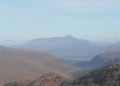
Western flank of the Nevis massif; from Sgùrr Dhòmhnuill
-
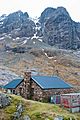
Charles Inglis Clark Memorial Hut with the Carn Dearg Buttress behind
-
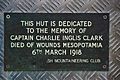
Memorial Plaque on the door of the CIC Hut
-
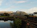
Ben Nevis viewed from Neptune's Staircase
-
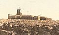
An undated photograph of the Ben Nevis observatory (1883–1904) and 'hotel' (hostel). The hotel began as a spare-room-for-hire within the observatory, and remained open until 1916.
-
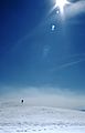
Wanderer near the summit in early May 1990.
-
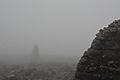
In thick fog, the navigational cairns can be difficult to see, but are important route markers
-
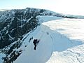
An ice-climber exiting Number Five Gully (450m I). Tower Gap can be discerned in the background.
-
Path to the CIC Hut alongside the Allt a' Mhuilinn


.jpg)
.jpg)


See also
 In Spanish: Ben Nevis para niños
