
Ben Macdui facts for kids
Quick facts for kids Ben Macdui |
|
|---|---|
| Beinn MacDuibh | |

Ben Macdui from the south
|
|
| Highest point | |
| Elevation | 1,309 m (4,295 ft) |
| Prominence | 950 m (3,120 ft) Ranked 9th in British Isles |
| Isolation | 86.5 km (53.8 miles) |
| Listing | Marilyn, Munro, Hardy, Council top (Aberdeenshire, Moray), County top (Aberdeenshire, Banffshire) |
| Naming | |
| English translation | MacDuff's mountain |
| Pronunciation | Scottish Gaelic: [ˈpeiɲ maxk ˈt̪ɯj] |
| Geography | |
|
Lua error in Module:Location_map at line 420: attempt to index field 'wikibase' (a nil value).
|
|
| Parent range | Cairngorms |
| OS grid | NN989989 |
| Topo map | OS Landranger 36, 43, Explorer OL57 |
Ben Macdui (pronounced "Ben Mac-doo-ee") is a very tall mountain in Scotland. Its name means "MacDuff's mountain" in Scottish Gaelic. It's the second-highest mountain in all of Scotland and the British Isles, right after Ben Nevis. It's also the tallest mountain in the Cairngorms range. The top of Ben Macdui is 1,309 meters (about 4,295 feet) above sea level! It's known as a Munro, which is a Scottish mountain over 3,000 feet high. Ben Macdui sits on the edge of a large, flat area called the Cairngorm plateau. It looks over the Lairig Ghru pass to the west and Loch Etchachan to the east.
For a long time, people weren't sure if Ben Macdui or Ben Nevis was the tallest mountain in Britain. But after surveys in 1846 and 1847, it was confirmed that Ben Nevis was higher. At the very top of Ben Macdui, there's a special pointer put there in 1925. It shows you the directions to other important mountains you can see on a clear day. Sometimes, even in summer, you can find patches of snow on Ben Macdui.
Ben Macdui's History

The name "Ben Macdui" might come from a family called Mac Duibh. This family owned land around the mountain way back in 1187. Since the mountain was the western edge of their land, some historians think it was named after them. Another idea is that the name comes from the Gaelic words for "black pig," because of the mountain's shape.
In 1810, a person named Rev Dr Keith tried to measure the height of Ben Macdui using a special tool called a barometer. He thought it was about 4,300 feet tall. This made people wonder if it was taller than Ben Nevis. To find out for sure, the Ordnance Survey built a special marker on the summit in 1847. This helped them measure the height very accurately, and they confirmed that Ben Nevis was indeed taller. The surveyors also built a small shelter, which people called the "Sappers' Bothy." You can still see parts of it today.
A famous visitor to Ben Macdui was Queen Victoria. She hiked to the top on October 7, 1859, when she was 40 years old. She wrote about her trip, saying it felt "sublime and solemn," and "so wild, so solitary."
During the Second World War, soldiers training in the Cairngorms also visited the summit of Ben Macdui. They built small shelters near the top. Sadly, a plane crashed near the summit in early 1940.
Climbing Ben Macdui
Climbing Ben Macdui can be an exciting adventure! One of the easiest ways to reach the top is from the Coire Cas car park, which is near the Cairngorm Ski Centre. From there, a path leads you up over gentle hills. This walk is about seven miles long. You can also take a slightly longer path that lets you climb Cairn Gorm too.
Another way to climb is by following a path from Loch Etchachan. You can get to this loch from Loch Avon to the north or by walking up from Glen Derry to the south. Some people also choose to come over Derry Cairngorm or through the Lairig Ghru pass, which is to the west of Ben Macdui. If you're starting from the south, many people use a bicycle for the first five miles from Linn of Dee to Derry Lodge.
The Big Grey Man
The area around Ben Macdui is famous for a mysterious legend called Am Fear Liath Mòr, which means 'the Big Grey Man' in Scottish Gaelic. People have reported strange feelings or sounds on the mountain. One famous mountaineer, J. Norman Collie, claimed he heard footsteps and felt a strange presence, which made him run away from the summit in fear! It's a spooky story that adds to the mountain's mystery.
Images for kids
-

View from the northwest on Braeriach
-
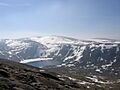
View from the east on Beinn Mheadhoin, inside the Cairngorm plateau
-
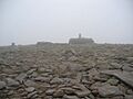
Summit of Ben Macdui
-
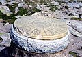
Summit indicator erected by the Cairngorm Club in 1925


See also
 In Spanish: Ben Macdui para niños
