
Lochaber facts for kids


.PNG)
Lochaber is a special part of the Scottish Highlands. Long ago, it was a historic area made up of two parishes, Kilmallie and Kilmonivaig. It stretched from Loch Leven in the south to beyond Spean Bridge and Roybridge in the north.
Today, Lochaber is a larger area. It's one of the 16 "ward management areas" of the Highland Council in Scotland. The main town in Lochaber is Fort William.
There's a legend that a glaistig once lived here. A glaistig is a mythical creature, a bit like a ghostly woman mixed with a goat!
Contents
What's in a Name?
Experts have different ideas about where the name Lochaber comes from. One idea is that Abar comes from old languages like Pictish and Welsh, meaning "river mouth." So, Loch Abar could mean the place where the Lochy and the Nevis rivers meet and flow into Loch Linnhe.
Another idea is that abar comes from a Gaelic word meaning "mud" or "swampy place." If this is true, then Lochaber could mean "the loch of swamps." There used to be a large swampy area where the local high school and health centre are now.
People from Lochaber are called Abrach.
A Look Back in Time

Lochaber was first mentioned in a book around the year 690. Even though we haven't found many Pictish stones here, people believe that Ardnamurchan Point was the border between the lands of the Picts (an ancient people of Scotland) and the Irish clans who moved into Scotland.
Archaeologists have found signs that Inverlochy Castle might have been built on the site of an older Pictish settlement. One historian wrote in 1526 that it was a "city" where merchants from France and Spain often visited, but it was later destroyed by the Vikings.
While there aren't many early monasteries in Lochaber, many place names start with "Kil-" or "Cille-." These names suggest there were early Christian sites here between 600 and 900 AD. Some place names also suggest that Vikings settled in nearby areas like Morvern and Ballachulish.
Lochaber became part of a larger area called the Province of Moray around the 1100s. By the late 1200s, it was known as a "provincial lordship." This meant it was a special area ruled by a lord. Lochaber was made up of the two parishes, Kilmallie and Kilmonivaig, and its main castle was Inverlochy Castle.
King Robert Bruce, a famous Scottish king, gave Lochaber to his friend Angus Og Macdonald, the Lord of the Isles. This was after Angus Og fought alongside him in important battles, like the Battle of Bannockburn in 1314. Later, in 1376, King Robert II confirmed that Lochaber would belong to John Macdonald, another Lord of the Isles, and his wife, Princess Margaret.
In the Middle Ages, the Clan Cameron was the most powerful clan in Lochaber. Other important clans included the MacDonald of Keppoch, MacDonell of Glengarry, MacMillan, and MacIntosh.
In the 1700s, a Catholic priest named Fr. Alexander Cameron lived in Lochaber. He was a nobleman from the Clan Cameron. He ran a very successful church for the Catholic Church in Scotland, which was illegal at the time. He even served as a chaplain (a priest for soldiers) for the Jacobite Army during the Uprising of 1745. After the Battle of Culloden in 1746, he was captured and died on a prison ship.
The time after the Battle of Culloden was very hard for the Highlands. It's known as Bliadhna nan Creach, which means "The Year of the Pillaging." Lochaber suffered a lot from the British Army's actions.
Later, many local people left Lochaber because of the Highland Clearances (when landlords forced people off their land) or because they chose to move away. So many people left that a Canadian Gaelic poet wrote in 1900 that "the best singers and Seanachies (storytellers) left Scotland. They left Lochaber for certain."

In the mid-1800s, new local government rules changed how Scotland was divided. Lochaber became part of the new county of Inverness-shire.
From 1975 to 1996, Lochaber was a "district" within the larger Highland region. This district included many areas like Glen Coe, Moidart, and even some small islands like Rùm and Eigg.
In 1996, the system changed again. All the districts in the Highlands were combined into one large Highland Council area. The old district areas, including Lochaber, became "management areas" for the council.
How Lochaber is Governed Today
Today, the Lochaber area is part of the Highland Council's Ross, Skye and Lochaber management area. This larger area has six "wards," which are like smaller voting districts.
The Lochaber area itself has two wards:
- The Caol and Mallaig ward, which elects three councillors (local representatives).
- The Fort William and Ardnamurchan ward, which elects four councillors.
Lochaber is also part of the Ross, Skye and Lochaber constituency for the UK Parliament in London. This means people in Lochaber vote for a Member of Parliament (MP) to represent them in the national government.
See also
- Lochaber axe
- Lochaber Narrow Gauge Railway
Images for kids
-
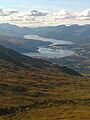
Loch Eil
-
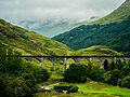
The viaduct at Glenfinnan
-
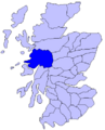
Map of Scotland showing the historic province of Lochaber
