
Inverness-shire facts for kids
Quick facts for kids
Inverness-shire
|
|
|---|---|
 |
|
| Country | Scotland |
| County town | Inverness |
| Area | |
| • Total | 4,211 sq mi (10,906 km2) |
| Ranked 1st of 34 | |
| Chapman code |
INV
|
Inverness-shire (which is Siorrachd Inbhir Nis in Scottish Gaelic) is a historic county in Scotland. It's also a registration county and a lieutenancy area. This means it's an important historical region.
It covers a big part of the Highlands and the Outer Hebrides islands. Inverness-shire is Scotland's largest county by land area. However, it has one of the smallest populations, with about 67,733 people. This is only a small part of Scotland's total population.
Contents
What is Inverness-shire?
The area known as Inverness-shire has changed over time. Today, the lieutenancy area (which is a ceremonial region) includes parts of Inverness, Badenoch & Strathspey, and Lochaber. This is a bit different from the historic county. For example, it includes some areas that used to be part of Moray and Argyll. But it does not include the Outer Hebrides, which now have their own lieutenancy area called the Western Isles.
Geography of Inverness-shire


Inverness-shire is the biggest county in Scotland. It's also the second largest in the whole UK, after Yorkshire. It shares borders with Ross-shire to the north and Perthshire and Argyllshire to the south. To the east, it borders Nairnshire, Moray, Banffshire, and Aberdeenshire.
The mainland part of Inverness-shire is a large area of the Scottish Highlands. To the west, it touches the Sea of the Hebrides. To the east, it reaches the Beauly Firth and Moray Firth, which lead to the North Sea.
The county is split in two by the Great Glen. This is a long geological fault, about 60 miles long. It runs from the southwest to the northeast. This glen separates the Northwest Highlands from the Grampian Mountains. Inside the Great Glen, you'll find famous lochs like Loch Ness (Scotland's second largest), Loch Oich, and Loch Lochy. These lochs are connected by the Caledonian Canal.
Ben Nevis, the tallest mountain in Britain, is located in Inverness-shire. It's found east of Fort William. The west coast of the county has many large peninsulas and long sea inlets. This area was once called the "Rough Bounds" because it was so remote. Even today, it's wild and not many people live there.
Inverness-shire is generally a mountainous area. It has many lochs (lakes) scattered throughout. Some of the largest include Loch Ness, Loch Morar, and Loch Laggan.
Islands of Inverness-shire
Inverness-shire also includes many islands off its west coast. These are part of the Inner Hebrides. The largest of these is Skye. It's separated from the mainland by the Sound of Sleat. Skye is a very popular place for tourists. It's a huge island, the second biggest in Scotland. The small island of Eigg is also part of Inverness-shire.
Further west, across the Little Minch, most of the Outer Hebrides islands are in Inverness-shire. However, Lewis is an exception, as it's in Ross-shire. Even further west are the very remote islands of St Kilda. No one has lived there since 1930. Much, much further west is Rockall, a tiny, uninhabitable island.
Coat of Arms

The coat of arms for Inverness-shire has special symbols. It shows a stag's head and a bull's head. These come from the symbols of important local families, the Frasers of Lovat and the MacLeods. There is also a galley, which is an old type of ship. This ship represents the Clan Chattan, a powerful group of clans.
Below the shield, there's a banner with a motto in Gaelic: Air son Math na Siorrachd. This means "For the Good of the County".
Local Government
Past Government (1890–1975)
.jpg)
In 1890, Inverness-shire got its own county council. This council helped manage the area. The county's borders were also changed to make it one continuous area.
Even with the new council, some towns like Inverness, Fort William, and Kingussie had their own town councils. This meant they had some freedom from the county council. The county council's main office was first in Inverness Castle. Later, in 1963, it moved to new offices on Ardross Street.
Changes in Government (1975–1996)
In 1975, the old county councils were stopped. Scotland then had a new system with two levels of government: regions and districts. Mainland Inverness-shire was split into four districts within the Highland region. The parts of Inverness-shire in the Outer Hebrides became part of the new Western Isles council area.
For example, the town of Inverness and nearby areas became the Inverness district. Fort William and its area joined parts of Argyll to form the Lochaber district.
Current Government (1996–Present)
In 1996, the two-level system was changed again. The Highland region became a single, unified council area. This new Highland Council now manages everything.
The council divides its large area into smaller "management areas" to help with local issues. The city of Inverness and its surrounding area is one of these important management areas.
Civil Parishes
Civil parishes are old divisions of land. They are still used today for some statistics, like counting populations. This helps people compare how many people lived in an area over a long time.
In the past, Inverness-shire had many civil parishes. Some of these were Abernethy and Kincardine, Barra, Glenelg, and Portree on Skye. Over the years, many of these smaller parishes joined together to form larger ones.
Transport

.jpg)
You can travel around Inverness-shire in many ways. Train lines connect Inverness to places like Perth in the south and Kyle of Lochalsh to the west. Another line connects Fort William to Mallaig.
The Isle of Skye is connected to the mainland by the Skye Bridge. This bridge makes it easy to drive to the island.
Bus companies like Stagecoach Group and Scottish Citylink serve the larger towns. Many ferries also connect the islands of the Outer Hebrides and Inner Hebrides to the Scottish Mainland.
There are three airports in the county: Inverness, Benbecula, and Barra. All of them have flights within Scotland. Inverness also flies to other UK cities and some places in Europe. Barra Airport is very special because it's the only airport in the world where regular flights land on a beach!
Main Towns and Villages
Inverness-shire has many towns and villages. The main town is Inverness, which is the county seat. Other important places on the mainland include Fort William, Aviemore, Kingussie, and Mallaig.
On the islands, key settlements include Portree on Skye, Castlebay on Barra, and Lochmaddy on North Uist. These places are important centers for the island communities.
Parliamentary Representation
A parliamentary constituency is an area that elects a person to represent it in parliament. Inverness-shire has had its own representatives in the UK Parliament for a long time.
From 1708 to 1918, there was an Inverness-shire constituency. This area elected a Member of Parliament (MP) to the Parliament of Great Britain and later the Parliament of the United Kingdom. The town of Inverness itself had its own separate representation.
Since 1983, the areas that make up the historic Inverness-shire have been part of different constituencies. These include areas like Inverness, Nairn and Lochaber. Today, the area is mostly covered by the Inverness, Nairn, Badenoch and Strathspey constituency for the UK Parliament.
The same areas also elect members to the Scottish Parliament in Holyrood. These constituencies are part of the Highlands and Islands electoral region.
Images for kids
-
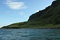
Coast of Eigg
-
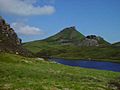
Dùn Caan mountain on Raasay
-
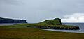
Oronsay
-
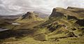
Landscape of northern Skye
-
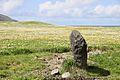
Standing stone on Barra
-
The 'lazy beds' of Harris
-
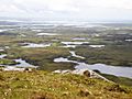
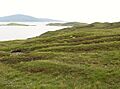
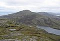
Lakes of North Uist
-
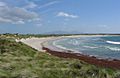
Beach on Benbecula
-
Mountains on South Uist
-
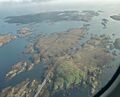
Eilean na Cille (at right), Triallabreac and Wiay from the air
-
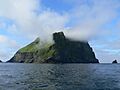
Soay
-
Rockall
-
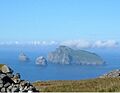
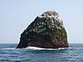
Boreray with Stac and Armin (left) and Stac Lee (right)


