
Rockall facts for kids

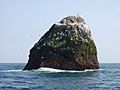
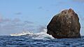
Photograph of Rockall in 2008
|
|

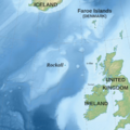
Topographic map centred on Rockall
|
|
| Geography | |
|---|---|
| Location | North-east Atlantic |
| Coordinates | 57°35′46.7″N 13°41′14.3″W / 57.596306°N 13.687306°W |
| OS grid reference | MC035165 |
| Area | 784.3 m2 (8,442 sq ft) |
| Highest elevation | 17.15 m (56.27 ft) |
| Administration | |
| Country | |
| Council area | Comhairle nan Eilean Siar |
| Demographics | |
| Population | 0 |
Rockall is a very small, lonely rock in the middle of the North Atlantic Ocean. It's made of granite and is so tiny that no one lives there. The United Kingdom says Rockall is part of its territory and its special sea area, but some nearby countries don't agree.
This small islet is quite far from other land. It is about 301.3 kilometres (187.2 miles; 162.7 nautical miles) west of Soay, an island in Scotland. It's also 423.2 kilometres (263.0 miles; 228.5 nautical miles) northwest of Tory Island in Ireland. The nearest place where people live all the time is North Uist in Scotland, which is about 370 kilometres (230 mi; 200 nmi) to the east.
The United Kingdom officially claimed Rockall in 1955. In 1972, they made it part of Scotland. The UK doesn't use Rockall to claim a huge special economic zone (EEZ) in the sea. This is because they follow an international rule called the United Nations Convention on the Law of the Sea (UNCLOS). This rule says that small rocks where people can't live or work don't get a large EEZ. However, they can still have a smaller "territorial sea" that goes out 12 nautical miles (22 kilometres). Ireland doesn't agree with the UK's claim to Rockall. Ireland believes the rock shouldn't give the UK any special rights to the sea or its resources.
What's in a Name? The Story of Rockall's Name
The name Rockall has a mysterious past. No one is completely sure where it came from or what it means.
Some people think the name comes from an old Norse word. This word might have included fjall, which means 'mountain'. Another idea is that it comes from Norse words meaning 'foaming sea' and 'bald head'. This makes sense because Rockall is a bare rock often hit by big waves.
There's also a Scottish Gaelic name for the islet, Ròcal. Some believe it comes from Gaelic words meaning 'skerry of roaring' or 'sea rock of roaring'.
The first time Rockall was mentioned in writing was around 1594 on a Dutch map. It was called Rookol. Later, in 1703, a book called A Description of the Western Isles of Scotland mentioned it as Rokol. The book also said that people from the nearby island of St Kilda called it Rokabarra.
In Scottish Gaelic folklore, there's a mythical rock called Rocabarraigh. Legend says it will appear three times, and its last appearance will be at the end of the world.
Rockall's Interesting History
This 17.15-metre-high (56.3 ft) rock has been known for a long time. In the 20th century, it became important because countries wanted to claim rights to oil and fishing in the surrounding sea.
Lord Kennet described Rockall in 1971 as "the most desolate, despairing and awful" place. It's so famous for its isolation that it gives its name to one of the sea areas in the shipping forecast, which is a weather report for ships.
Rockall has attracted many adventurers and amateur radio fans. Fewer than 20 people have ever landed on the rock. The longest anyone has stayed there is 45 days, which happened in 2014. In 1971, a politician joked that "More people have landed on the moon than have landed on Rockall." (Only 12 people have landed on the moon).
Early Explorers and Landings

The first recorded landing on Rockall was on September 8, 1811. A Royal Navy officer named Basil Hall led a small group from his ship, HMS Endymion. They faced a scary situation when thick fog rolled in, making it hard for their ship to find them again. Luckily, they were eventually rescued. Hall wrote about this adventure in his book.
Another landing happened in 1862 by a Mr. Johns from HMS Porcupine. His ship was surveying the seabed for a transatlantic telegraph cable.
The UK Claims Rockall

On September 18, 1955, the UK officially claimed Rockall. A team from the Royal Navy, including Lieutenant-Commander Desmond Scott and a naturalist named James Fisher, landed on the island. They were lowered onto the rock by a helicopter.
The team cemented a brass plaque on a small ledge and raised the Union Flag. This was the last time the British Empire officially expanded its territory.
The main reason for claiming Rockall was a secret one. The UK was planning to test its first guided nuclear weapon. They were worried that if Rockall wasn't claimed, the Soviet Union might use it to spy on the missile tests. So, the British government decided to claim the island quickly.
In 1971, another government expedition, called "Operation Top Hat," visited Rockall. They used explosives to flatten the top of the rock. This was to prepare it for a light beacon, which was installed the next year. This helped the UK strengthen its claim to the island and the seabed rights around it.
Modern Adventures and Protests
In 1985, a survival expert named Tom McClean lived on Rockall for 45 days. He did this to support the UK's claim to the islet.
In 1997, the environmental group Greenpeace briefly took over the islet. They called it Waveland and protested against oil exploration. They even tried to declare it a "new Global State." The British government simply said that "Rockall is British territory" and ignored their protest. A Greenpeace member even turned the 1955 plaque around!
In 2014, explorer Nick Hancock stayed on Rockall for 45 days, breaking the previous record. He did this to raise money for charity.
Rockall is also a turning point for sailing races, like the "Round Rockall" race from Galway, Ireland.
Rockall's Location and Features

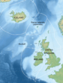
Rockall is one of the highest points of a larger underwater area called Helen's Reef. It's about 301.3 kilometres (162.7 nautical miles) west of Soay, Scotland. The seabed around Rockall is called the Rockall Bank, and it's part of the larger Rockall Plateau. A deep area called the Rockall Trough separates it from the Outer Hebrides of Scotland.
A scientist named James Fisher once called Rockall "the most isolated small rock in the oceans of the world." Other nearby rocks are even smaller and often completely covered by waves.
Rockall is about 25 metres (80 ft) wide and 31 metres (100 ft) long at its base. It rises sharply to a height of 17.15 metres (56.3 ft). Big storm waves often wash over it, especially in winter. There's a small ledge called Hall's Ledge, which is the only named spot on the rock.

The nearest land is the uninhabited Scottish island of Soay, 301.3 kilometres (162.7 nmi) to the east. The nearest permanently inhabited place is North Uist, about 366.8 km (198.1 nmi) away.
The area around Rockall was first mapped in detail in 1831 by Captain Alexander Thomas Emeric Vidal of the Royal Navy. The first scientific trip to Rockall happened in 1896 to study its plants and animals.
Rockall is in the path of the Gulf Stream, which is a warm ocean current. This means the rock has a very maritime climate, without extreme heat or cold.
Rockall's Geology: What It's Made Of

Rockall is made of a special type of granite that has a lot of sodium and potassium. It also has darker bands with iron-rich minerals. Geologists once called this darker rock "rockallite," but that name isn't used much anymore.
In 1975, a brand new mineral was found in a rock sample from Rockall! It was named bazirite, after the elements barium and zirconium that it contains.
Rockall is part of a very old volcanic area that formed about 55 million years ago. This was when the ancient continent of Laurasia split apart, creating the North Atlantic Ocean. Rockall was left behind as an isolated islet.
Scientists have used ships to survey the seabed around Rockall to learn more about its geology.
Life Around Rockall: Plants and Animals
Rockall itself doesn't have much life. Only small sea snails and other molluscs live there all the time. Some seabirds, like fulmars, northern gannets, and black-legged kittiwakes, use the rock to rest in summer. Sometimes, if the weather is calm, gannets and guillemots might even lay eggs and raise their young there. In total, over twenty types of seabirds and six other animal species have been seen on or near the islet.
Under the water, around the wider Rockall Bank, there are special coral reefs. These are important habitats for sea creatures.
Discovery of New Species
In 2013, scientists from Marine Scotland found four brand new species of animals in the sea around Rockall! These animals are thought to live in areas where natural gases leak from the seabed. This discovery has led to discussions about protecting these unique parts of the ocean. The new species found include:
Who Owns Rockall?

The ownership of Rockall and the surrounding sea is a bit complicated.
Ireland's View
Ireland believes Rockall is important because it's close to their coast. However, Ireland has never officially claimed the rock for itself. Even though Rockall is closer to the UK, Ireland doesn't agree with the UK's claim to it. This means Ireland doesn't think Rockall should give the UK a 12-mile territorial sea.
Ireland believes that Rockall, being uninhabitable, should not affect the boundaries of Exclusive Economic Zones (EEZs). This is based on the UNCLOS rule that rocks where people can't live or work don't get an EEZ.
In 1988, Ireland and the UK signed an agreement about their EEZ boundaries. They decided to ignore Rockall when drawing these lines. However, in 2014, the UK and Ireland published new EEZ maps that show Rockall inside the UK's EEZ.
In 2012, an Irish newspaper published a photo of an Irish Navy ship sailing past Rockall. They said it showed Ireland exercising its rights in the area.
United Kingdom's View

The UK claims Rockall and a 12-nautical-mile (22.2 km; 13.8 mi) territorial sea around it. This area is inside the UK's exclusive economic zone (EEZ). The UK also claims the airspace above Rockall.
As mentioned, the UK claimed Rockall in 1955. Before this, it was considered terra nullius, meaning 'nobody's land'. In 1972, the British Island of Rockall Act officially made Rockall part of the UK.
The UK considers Rockall to be part of the Isle of Harris in Scotland. A navigational beacon was put on the island in 1982. The UK initially said no ships could come within 50-mile (80 km) of the rock. However, after agreeing to UNCLOS in 1997, they now only claim a 12-nautical-mile territorial sea, allowing ships to pass freely beyond that.
Since Rockall is within the UK's EEZ, the UK has special rights to explore, use, protect, and manage the natural resources there, including the marine environment.
In 2017, old documents showed that the UK claimed Rockall in 1955 because they were worried it could be used by "hostile agents" (like spies) to watch their missile tests.
In 2021, after Brexit, an Irish fishing boat was told by Marine Scotland to leave the 12-nautical-mile zone around Rockall.
Shipwrecks Near Rockall
There have been several shipwrecks on the rocks near Rockall, especially on Hasselwood Rock and Helen's Reef.
- In 1686, a Spanish or French ship ran aground near Rockall. Some sailors managed to reach St. Kilda in a small boat and survived.
- In 1824, a ship called Helen from Dundee sank on Helen's Reef, and people died.
- In 1904, a Danish ship called SS Norge sank on Hasselwood Rock. Nearly all of its 750 passengers were lost. This terrible event led to ideas for putting a lighthouse or lightship near the rock.
Images for kids
-
Photograph of Rockall in 2008
-
Topographic map centred on Rockall
-
The Rockall Trough separating Ireland and Scotland from the Rockall Plateau on which Rockall is situated
-
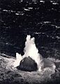
Unusually large winter waves breaking over the islet, 11 March 1943
-
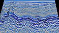
Seabed oil survey
-
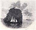
An illustration depicting HMS Endymion's landing party in their boat at Rockall, with Endymion in the background
-
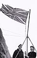
Lieutenant Commander Desmond Scott hoists the Union Flag in 1955.
-
The Irish Naval Service vessel Róisín at Rockall conducting routine maritime security patrols 230 nmi (430 km) off the north-west coast of Ireland
-
Exclusive economic zones of the UK, Ireland, Faroe Islands (Denmark), and Iceland around Rockall
-
ROCKALL – Nautical chart – Atlantic Sea Pilot, 1884
_p0231_ROCKALL.jpg)
See also
 In Spanish: Rockall para niños
